Niers
| Niers | |
|---|---|
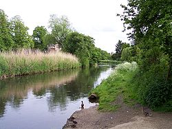 The Niers at Weeze | |
 Overview map | |
| Location | |
| Countries | |
| Physical characteristics | |
| Source | |
| • location | Lower Rhine region |
| • coordinates | 51°04′49″N 6°23′31″E / 51.08028°N 6.39194°E |
| • elevation | ±75 m (246 ft) |
| Mouth | |
• location | Maas |
• coordinates | 51°42′50″N 5°56′51″E / 51.71389°N 5.94750°ECoordinates: 51°42′50″N 5°56′51″E / 51.71389°N 5.94750°E |
| Length | 113.1 km (70.3 mi) [1] |
| Basin size | 1,373 km2 (530 sq mi) [1] |
| Basin features | |
| Progression | Meuse→ North Sea |

The Niers (pronounced neerce) is a river in Germany and The Netherlands, a right tributary of the river Maas (Meuse). Its wellspring is near Erkelenz, south of Mönchengladbach, in North Rhine-Westphalia (Germany).
Course and length[]
The Niers flows through Mönchengladbach, Viersen, Wachtendonk, Geldern and Goch before flowing into the Meuse just across the border with the Netherlands, in Gennep, Limburg (Netherlands).
Its overall length is 116 km - 108 km in Germany, 8 km in the Netherlands.
See also[]
- List of rivers of North Rhine-Westphalia
- Meuse#Tributaries
References[]
External links[]
| Authority control |
|---|
This Dutch Limburg location article is a stub. You can help Wikipedia by . |
Categories:
- Niers basin
- Rivers of Limburg (Netherlands)
- Rivers of North Rhine-Westphalia
- Rivers of the Netherlands
- Gennep
- Rivers of Germany
- International rivers of Europe
- North Rhine-Westphalia river stubs
- Limburg (Netherlands) geography stubs
- Europe river stubs
- Netherlands geography stubs