Wachtendonk
Wachtendonk | |
|---|---|
 Coat of arms | |
show Location of Wachtendonk within Kleve district | |
 Wachtendonk | |
| Coordinates: 51°24′33″N 6°20′16″E / 51.40917°N 6.33778°ECoordinates: 51°24′33″N 6°20′16″E / 51.40917°N 6.33778°E | |
| Country | Germany |
| State | North Rhine-Westphalia |
| Admin. region | Düsseldorf |
| District | Kleve |
| Subdivisions | 2 |
| Government | |
| • Mayor (2020–25) | Paul Robert Hoene[1] |
| Area | |
| • Total | 48.1 km2 (18.6 sq mi) |
| Elevation | 29 m (95 ft) |
| Population (2020-12-31)[2] | |
| • Total | 8,107 |
| • Density | 170/km2 (440/sq mi) |
| Time zone | UTC+01:00 (CET) |
| • Summer (DST) | UTC+02:00 (CEST) |
| Postal codes | 47669 |
| Dialling codes | 0 28 36 |
| Vehicle registration | KLE |
| Website | www.wachtendonk.de |


Wachtendonk at the confluence of Niers River and Nette River is a municipality in the district of Kleve in North Rhine-Westphalia, Germany. It is located west of the Rhine half way between Duisburg and Venlo at the Dutch border. Its name means 'bailiff's Donk' (Donk = slight elevation within a swampy area).
Gallery[]
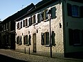
Feldstrasse

Old Monastery 'Thal Josaphat'
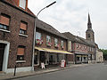
Wankum, church (Sankt Martin Kirche) in the street


References[]
- ^ Wahlergebnisse in NRW Kommunalwahlen 2020, Land Nordrhein-Westfalen, accessed 21 June 2021.
- ^ "Bevölkerung der Gemeinden Nordrhein-Westfalens am 31. Dezember 2020" (in German). Landesbetrieb Information und Technik NRW. Retrieved 21 June 2021.
External links[]
- Official website
 (in German)
| Wikimedia Commons has media related to Wachtendonk. |
| show Towns and municipalities in Kleve (district) |
|---|
| show Authority control |
|---|
This Kleve district location article is a stub. You can help Wikipedia by . |
Categories:
- Municipalities in North Rhine-Westphalia
- Kleve (district)
- Düsseldorf region geography stubs