Rheurdt
Rheurdt | |
|---|---|
 Coat of arms | |
show Location of Rheurdt within Kleve district | |
 Rheurdt | |
| Coordinates: 51°28′00″N 06°28′00″E / 51.46667°N 6.46667°ECoordinates: 51°28′00″N 06°28′00″E / 51.46667°N 6.46667°E | |
| Country | Germany |
| State | North Rhine-Westphalia |
| Admin. region | Düsseldorf |
| District | Kleve |
| Subdivisions | 2 |
| Government | |
| • Mayor (2020–25) | Dirk Ketelaers[1] (SPD) |
| Area | |
| • Total | 30 km2 (10 sq mi) |
| Elevation | 30 m (100 ft) |
| Population (2020-12-31)[2] | |
| • Total | 6,545 |
| • Density | 220/km2 (570/sq mi) |
| Time zone | UTC+01:00 (CET) |
| • Summer (DST) | UTC+02:00 (CEST) |
| Postal codes | 47509 |
| Dialling codes | 0 28 45 / 0 28 33 |
| Vehicle registration | KLE |
| Website | www.rheurdt.de |


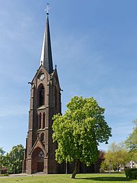
Rheurdt, church: Pfarrkirche Sankt Nikolaus
Rheurdt (German pronunciation: [ʁøːɐ̯t]) is a municipality in the district of Cleves, in North Rhine-Westphalia, Germany. It is located approximately 10 km west of Moers.
References[]
- ^ Wahlergebnisse in NRW Kommunalwahlen 2020, Land Nordrhein-Westfalen, accessed 21 June 2021.
- ^ "Bevölkerung der Gemeinden Nordrhein-Westfalens am 31. Dezember 2020" (in German). Landesbetrieb Information und Technik NRW. Retrieved 21 June 2021.
| show Towns and municipalities in Kleve (district) |
|---|
| show Authority control |
|---|
This Kleve district location article is a stub. You can help Wikipedia by . |
Categories:
- Municipalities in North Rhine-Westphalia
- Kleve (district)
- Düsseldorf region geography stubs