Nogoa River
| Nogoa | |
|---|---|
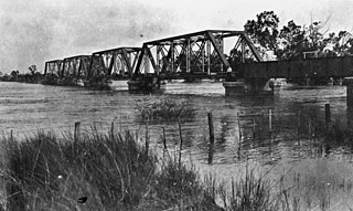 Railway bridge in Emerald during a flood, 1918 | |
 Location of Nogoa River mouth in Queensland | |
| Location | |
| Country | Australia |
| State | Queensland |
| Region | Central Queensland |
| City | Emerald |
| Physical characteristics | |
| Source | Carnarvon Range |
| • location | Carnarvon National Park |
| • coordinates | 24°51′38″S 147°00′16″E / 24.86056°S 147.00444°E |
| • elevation | 501 m (1,644 ft) |
| Mouth | confluence with Comet River, forming the Mackenzie River |
• location | north of Comet |
• coordinates | 23°33′21″S 148°32′11″E / 23.55583°S 148.53639°ECoordinates: 23°33′21″S 148°32′11″E / 23.55583°S 148.53639°E |
• elevation | 144 m (472 ft) |
| Length | 569 km (354 mi) |
| Basin size | 27,690 km2 (10,690 sq mi)[1] |
| Basin features | |
| River system | Fitzroy River basin |
| National parks | Carnarvon National Park, Minerva Hills National Park, Peak Range National Park, Snake Range National Park |
| [2] | |

The Nogoa River is a river located in Central Queensland, Australia.
Course and features[]
The river rises on the Carnarvon Range, part of the Great Dividing Range, in the Carnarvon National Park and flows in a generally north easterly direction towards Emerald. From source to mouth, the Nogoa River is joined by 29 minor tributaries. North of Comet the river forms confluence with the Comet River to form the Mackenzie River. The Nogoa descends 361 metres (1,184 ft) over its 569-kilometre (354 mi) course. The river is crossed by the Gregory and Capricorn Highways at Emerald.[2]
The river has a catchment area of 27,690 square kilometres (10,690 sq mi) draining parts of the Minerva Hills, Peak Range, Snake Range national parks. Of this area, 271 kilometres (168 mi) is riverine wetlands.[1]
The reservoir created by Queensland's second largest dam,[3] Lake Maraboon was formed when the Fairbairn Dam was built on the river in 1972. The dam and a network of channels along the Nogoa River supplies water for the Emerald Irrigation Area.[4]
Sir Thomas Mitchell was the first European explorer to discover the river on 19 July 1846.[5]
Major flooding events[]
In January 2008, the Nogoa River reached record flood levels. During the flood, water levels in the Fairbairn Dam rapidly exceeded 100%.[6] Within a week inundations had caused severe disruptions to graziers, crops growers and to residents of Emerald when waters broke its banks. The Nogoa peaked at 15.4 m (51 ft) in Emerald on the night of January 22 2008, causing more than 2500 people to be evacuated.[7] The unprecedented floods washed through the Ensham coal mine, temporarily halting operations in two out of six coal pits, reducing output to less than 50% and rendering a huge dragline defunct after it had been submerged.[8]
In December 2010 - January 2011 the river was impacted by major flooding at Emerald[9] and in the Nogoa's upper catchment.[10]
Cultural Heritage[]
The traditional owners include the Gayiri people who occupied the area for tens of thousands of years before European colonisation began in the nineteenth century. The Gayiri (Kairi, Khararya) language region takes in the landscape of the Central Highlands Regional Council, including Emerald and Nogoa River.[11]
See also[]
- List of rivers of Queensland
References[]
- ^ a b "Nogoa River drainage sub-basin". WetlandInfo. Department of Environment and Heritage Protection, Queensland Government. Retrieved 21 November 2015.
- ^ a b "Map of Nogoa River, QLD". Bonzle Digital Atlas of Australia. Retrieved 19 November 2015.
- ^ "Fairbairn Dam performed well during Emerald's major flood event" (Press release). SunWater. 4 February 2008. Archived from the original on 22 November 2015. Retrieved 21 November 2015.
- ^ "Water resources - Overview - Queensland - Basin & Surface Water Management Area: Nogoa / Mackenzie". Australian Natural Resources Atlas. Department of the Environment, Water, Heritage and the Arts. Archived from the original on 22 June 2009. Retrieved 20 May 2009.
- ^ "Nogoa River (entry 24444)". Queensland Place Names. Queensland Government. Retrieved 19 November 2015.
- ^ "Drought-stricken Fairbairn Dam overflows". 19 January 2008. Retrieved 20 January 2008.
- ^ Casey, Scott (23 January 2008). "Is Rockhampton next to flood?". The Brisbane Times. Retrieved 20 May 2009.
- ^ Morley, Peter (26 April 2008). "Central Highlands dragline a costly rust bucket". The Courier-Mail. Queensland Newspapers. Archived from the original on 27 April 2008. Retrieved 20 May 2009.
- ^ Cuff, Chris; Rasmussen, Cecily; Geochemical and Hydrobiological Solutions Pty Ltd (12 December 2011). "Section B: Fairbairn Dam – Emerald: Urban Flood Plain Analysis". Flood Management Analysis. Central Highlands Regional Council. Retrieved 21 November 2015.
- ^ Cuff, Chris; Rasmussen, Cecily; Geochemical and Hydrobiological Solutions Pty Ltd (12 December 2011). "Section A: Upper Nogoa – Fairbairn Dam Catchment Assessment and Evaluation". Flood Management Analysis. Central Highlands Regional Council. Retrieved 21 November 2015.
- ^
 This Wikipedia article incorporates CC-BY-4.0 licensed text from: "Gayiri". Queensland Aboriginal and Torres Strait Islander languages map. State Library of Queensland. Retrieved 5 February 2020.
Rivers of Queensland | |||||||||||||||
|---|---|---|---|---|---|---|---|---|---|---|---|---|---|---|---|
| |||||||||||||||
| |||||||||||||||
| |||||||||||||||
| |||||||||||||||
| |||||||||||||||
| |||||||||||||||
- Rivers of Queensland
- Queensland floods
- Central Queensland