Nordmaling Municipality
Nordmaling Municipality
Nordmalings kommun | |
|---|---|
 | |
 Coat of arms | |
 | |
| Coordinates: 63°34′N 19°30′E / 63.567°N 19.500°ECoordinates: 63°34′N 19°30′E / 63.567°N 19.500°E | |
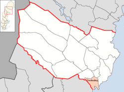
| Country | Sweden |
| County | Västerbotten County |
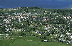
| Seat | Nordmaling |
| Area | |
| • Total | 2,472.26 km2 (954.54 sq mi) |
| • Land | 1,229.42 km2 (474.68 sq mi) |
| • Water | 1,242.84 km2 (479.86 sq mi) |
| Area as of 1 January 2014. | |
| Population (31 December 2019)[2] | |
| • Total | 7,143 |
| • Density | 2.9/km2 (7.5/sq mi) |
| Time zone | UTC+1 (CET) |
| • Summer (DST) | UTC+2 (CEST) |
| ISO 3166 code | SE |
| Province | Ångermanland |
| Municipal code | 2401 |
| Website | www.nordmaling.se |

Nordmaling Municipality (Swedish: Nordmalings kommun) is a municipality in Västerbotten County in northern Sweden. Its seat is located in Nordmaling.
History[]
The municipal system in Sweden was introduced in 1863 and Nordmaling Municipality was one of the entities created out of a parish. In 1914 a part of the municipality was detached. The subdivision reforms of 1952 and 1971 did not affect the municipality.
Localities[]
There are three localities (or urban areas) in Nordmaling Municipality:[3]
| # | Locality | Population |
|---|---|---|
| 1 | Nordmaling | 2,619 |
| 2 | Rundvik | 911 |
| 3 | Lögdeå | 414 |
The municipal seat in bold
References[]
- ^ "Statistiska centralbyrån, Kommunarealer den 1 januari 2014" (in Swedish). Statistics Sweden. 2014-01-01. Archived from the original (Microsoft Excel) on 2016-09-27. Retrieved 2014-04-18.
- ^ "Folkmängd i riket, län och kommuner 31 december 2019" (in Swedish). Statistics Sweden. February 20, 2020. Retrieved February 20, 2020.
- ^ Statistics Sweden as of December 31, 2005
External links[]
 Media related to Nordmaling Municipality at Wikimedia Commons
- Nordmaling Municipality - Official site
Places adjacent to Nordmaling Municipality | ||||||||||||||||
|---|---|---|---|---|---|---|---|---|---|---|---|---|---|---|---|---|
| ||||||||||||||||
Municipalities and seats of Västerbotten County | ||
|---|---|---|
| Municipalities | ||
| Municipal seats | ||
| Authority control |
|
|---|
Categories:
- Municipalities of Västerbotten County