North Carolina Highway 45
 | ||||
|---|---|---|---|---|
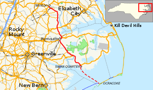 Route of NC 45 highlighted in red; Swan Quarter-Ocracoke Ferry in dashed red | ||||
| Route information | ||||
| Maintained by NCDOT | ||||
| Length | 121.7 mi[1] (195.9 km) | |||
| Existed | 1940–present | |||
| Tourist routes | ||||
| Major junctions | ||||
| South end | ||||
| North end | ||||
| Location | ||||
| Counties | Hyde, Beaufort, Washington, Bertie, Hertford | |||
| Highway system | ||||
| ||||
| ||||
North Carolina Highway 45 (NC 45) is a primary state highway in the U.S. state of North Carolina. The highway traverses north-south, from Ocracoke to Winton.
Route description[]
This section needs expansion. You can help by . (February 2016) |
NC 45 starts at the ferry terminal at Ocracoke, connecting with NC 12, it traverses across the Pamlico Sound along the Swan Quarter-Ocracoke Ferry. At Swan Quarter, it continues at a northwesterly direction; merging with several highways along the way, including US 264, NC 99, NC 32, US 64, NC 308, and NC 461. North of Plymouth, it parallels west of the Chowan River before reaching its northern terminus at US 13/US 158, near Winton.
History[]
This section needs expansion. You can help by . (June 2013) |
On May 1, 2013, NC 45 was extended south from Swan Quarter to its current southern terminus in Ocracoke, crossing over the Pamlico Sound along the Swan Quarter-Ocracoke Ferry. NC 45 does not traverse beyond the ferry terminal.[2]
Major intersections[]
| County | Location | mi[1] | km | Destinations | Notes | |||
|---|---|---|---|---|---|---|---|---|
| Hyde | Ocracoke | 0.0 | 0.0 | |||||
| Pamlico Sound | 0.2– 30.2 | 0.32– 48.6 | ||||||
| Swan Quarter | 31.3 | 50.4 | Southern terminus of NC 94 | |||||
| 33.5 | 53.9 | South end of US 264 overlap | ||||||
| | 48.7 | 78.4 | North end of US 264 overlap | |||||
| Beaufort | 59.1 | 95.1 | South end of NC 99 overlap | |||||
| Hyde |
No major junctions | |||||||
| Washington | | 70.3 | 113.1 | South end of NC 32 and northern terminus of NC 99 | ||||
| | 73.6 | 118.4 | North end of NC 32 overlap | |||||
| | 77.0 | 123.9 | West end of US 64 and south end of NC 32 overlap | |||||
| | 77.3 | 124.4 | East end of US 64 and north end of NC 32 overlap | |||||
| | 78.8 | 126.8 | East end of NC 308 overlap | |||||
| Bertie | | 82.7 | 133.1 | West end of NC 308 overlap | ||||
| | 99.7 | 160.5 | ||||||
| Colerain | 102.6 | 165.1 | Eastern terminus of NC 42 | |||||
| Hertford | Harrellsville | 110.9 | 178.5 | Eastern terminus of NC 561 | ||||
| | 116.2 | 187.0 | East end of NC 461 overlap | |||||
| Winton | 120.8 | 194.4 | West end of NC 461 overlap | |||||
| 121.7 | 195.9 | West end of US 158 overlap | ||||||
1.000 mi = 1.609 km; 1.000 km = 0.621 mi
| ||||||||
See also[]
- North Carolina Bicycle Route 2 - concurrent with NC 45 from Swan Quarter to the northern US 264 intersection
References[]
- ^ a b Google (June 10, 2013). "North Carolina Highway 45" (Map). Google Maps. Google. Retrieved June 10, 2013.
- ^ "NC 45 Route Change (2013-05-01)" (PDF). North Carolina Department of Transportation. May 1, 2013. Retrieved June 10, 2013.
External links[]
| ( • help)
|
 Media related to North Carolina Highway 45 at Wikimedia Commons
- State highways in North Carolina
- Transportation in Hyde County, North Carolina
- Transportation in Beaufort County, North Carolina
- Transportation in Washington County, North Carolina
- Transportation in Bertie County, North Carolina
- Transportation in Hertford County, North Carolina
