Windsor, North Carolina
Windsor, North Carolina | |
|---|---|
 | |
 Location of Windsor, North Carolina | |
| Coordinates: 35°59′53″N 76°56′56″W / 35.99806°N 76.94889°WCoordinates: 35°59′53″N 76°56′56″W / 35.99806°N 76.94889°W | |
| Country | United States |
| State | North Carolina |
| County | Bertie |
| Area | |
| • Total | 2.8 sq mi (7.3 km2) |
| • Land | 2.8 sq mi (7.3 km2) |
| • Water | 0.0 sq mi (0.0 km2) |
| Elevation | 3 ft (1 m) |
| Population (2010) | |
| • Total | 3,630 |
| • Estimate (2018)[3] | 3,339 |
| • Density | 1,300/sq mi (500/km2) |
| Time zone | UTC-5 (Eastern (EST)) |
| • Summer (DST) | UTC-4 (EDT) |
| ZIP code | 27983 27959 |
| Area code(s) | 252 |
| FIPS code | 37-74680[1] |
| GNIS feature ID | 1023279[2] |
| Website | windsornc |

Windsor is a town in Bertie County, North Carolina, United States. The population was 3,630 at the 2010 census,[4] up from 2,283 at the 2000 census. It is the county seat of Bertie County, which is also the homeland of the Southern Band Tuscarora Tribe that remained in NC post Colonialism.[5] Windsor is located in North Carolina's Inner Banks region.
History[]
The land was historically the home of the Tuscarora people. Today, there are Tuscarora residents living in the village of Tandequemuc, now called Merry Hill.
Bertie County Courthouse, Bertie Memorial Hospital, Elmwood, Freeman Hotel, Hope Plantation, Jordan House, King House, Liberty Hall, Rosefield, and Windsor Historic District are listed on the National Register of Historic Places.[6]
In the early morning hours of August 4, 2020, an EF3 tornado spawned by Hurricane Isaias struck areas just outside of Windsor. The twister completely obliterated 12 mobile homes within a mobile home park outside of town, and flattened another poorly built house. The tornado killed 2 people and injured 14 others. The tornado would the strongest tropical cyclone spawned tornado since 2005. Governor Roy Cooper toured the damage area in the days following the event.[7][8]
Recreation[]
Windsor is a notable Inner Banks kayaking destination. Canoes and kayaks are offered, by the Town of Windsor and the Roanoke Cashie River Center to use on the generally calm waters of the Cashie River.[9]
Town of Windsor Parks and Recreation Department Facilities[]
- Livermon Park and Mini Zoo
- Cashie Wetlands Walk and Canoe Trail
- Craftsman and Farmers Museum
- Hoggard Mill Road Bridge Access
- Cashie River Campground
- Cashie Disk Golf Course
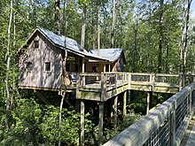
- Cashie River Tree Houses
- Windsor Tennis Courts
- Rotary Park
- Tuscarora village of Tandequemuc Longhouse
- Williford Park
- Cashie River ADAAG Fishing Piers and ADAAG Small Boat Launch and Trail[10]
Geography[]
Windsor is located at 35°59′53″N 76°56′56″W / 35.99806°N 76.94889°W (35.998145, -76.948973).[11]
According to the United States Census Bureau, the town has a total area of 2.8 square miles (7.3 km2), all of it land.[4]
Demographics[]
| Historical population | |||
|---|---|---|---|
| Census | Pop. | %± | |
| 1860 | 315 | — | |
| 1870 | 427 | 35.6% | |
| 1890 | 522 | — | |
| 1900 | 597 | 14.4% | |
| 1910 | 684 | 14.6% | |
| 1920 | 1,210 | 76.9% | |
| 1930 | 1,425 | 17.8% | |
| 1940 | 1,747 | 22.6% | |
| 1950 | 1,781 | 1.9% | |
| 1960 | 1,813 | 1.8% | |
| 1970 | 2,199 | 21.3% | |
| 1980 | 2,126 | −3.3% | |
| 1990 | 2,056 | −3.3% | |
| 2000 | 2,283 | 11.0% | |
| 2010 | 3,630 | 59.0% | |
| 2019 (est.) | 3,373 | [12] | −7.1% |
| U.S. Decennial Census[13] | |||
As of the census[1] of 2000, there were 2,283 people, 938 households, and 605 families residing in the town. The population density was 925.6 people per square mile (356.9/km2). There were 1,080 housing units at an average density of 437.9 per square mile (168.8/km2). The racial makeup of the town was 45.42% White, 52.96% African American, 20.35% Native American, 2.66% Asian, 0.04% Pacific Islander, 0.13% from other races, and 0.44% from two or more races. Hispanic or Latino of any race were 0.35% of the population.
In 2006, the State of North Carolina Department of Public Safety opened the Bertie Correctional Institution on Cooper Hill Road near Windsor. BCI is a medium-security prison with the capacity to house up to 1,504 inmates. The new prisoners contributed to the sudden growth in Windsor's population between the 2000 and 2010 census.
There were 938 households, out of which 28.5% had children under the age of 18 living with them, 42.2% were married couples living together, 20.3% had a female householder with no husband present, and 35.5% were non-families. 33.8% of all households were made up of individuals, and 17.0% had someone living alone who was 65 years of age or older. The average household size was 2.33 and the average family size was 2.96.
In the town, the population was spread out, with 24.8% under the age of 18, 5.5% from 18 to 24, 24.1% from 25 to 44, 24.1% from 45 to 64, and 21.4% who were 65 years of age or older. The median age was 42 years. For every 100 females, there were 75.9 males. For every 100 females age 18 and over, there were 69.9 males.
The median income for a household in the town was $25,256, and the median income for a family was $34,107. Males had a median income of $30,045 versus $20,885 for females. The per capita income for the town was $18,006. About 19.9% of families and 25.8% of the population were below the poverty line, including 35.1% of those under age 18 and 25.4% of those age 65 or over.
Notable people[]
- Frank Ballance (1942–2019), Democratic member of the United States House of Representatives
- , Tribal chair of the Southern Band Tuscarora Tribe, author
- Kent Bazemore (born 1989), NBA player for the Atlanta Hawks
- William Blount (1749–1800), delegate to the Philadelphia Convention and Senator for Tennessee who was expelled from the Senate
- Norma Bonniwell King (1877–1961), architect
- David Outlaw (1806–1868), Whig member of the United States House of Representatives
- George Outlaw (1771–1825), member of the United States House of Representatives
- Bosh Pritchard (1919–1996), NFL halfback
- Jethro Pugh (1944–2015), NFL defensive tackle for the Dallas Cowboys
- Tootie Robbins (1958–2020), NFL offensive tackle
- Francis D. Winston (1857–1941), North Carolina Lt. Governor and judge
- George T. Winston (1852–1932), educator and university administrator, brother to Francis
Education[]
References[]
- ^ Jump up to: a b "U.S. Census website". United States Census Bureau. Retrieved 2008-01-31.
- ^ "US Board on Geographic Names". United States Geological Survey. 2007-10-25. Retrieved 2008-01-31.
- ^ "Population and Housing Unit Estimates". Retrieved November 9, 2019.
- ^ Jump up to: a b "Geographic Identifiers: 2010 Demographic Profile Data (G001): Windsor town, North Carolina". U.S. Census Bureau, American Factfinder. Archived from the original on February 12, 2020. Retrieved February 6, 2014.
- ^ "Find a County". National Association of Counties. Retrieved 2011-06-07.
- ^ "National Register Information System". National Register of Historic Places. National Park Service. July 9, 2010.
- ^ Herzmann, Daryl. "IEM :: PNS from NWS AKQ". mesonet.agron.iastate.edu. Retrieved 2020-08-31.
- ^ US Department of Commerce, NOAA. "Summary of Tropical Storm Isaias". www.weather.gov. Retrieved 2020-08-31.
- ^ "About Us". Jeremy Maxik. Retrieved 2015-09-17.
- ^ "Our Parks". Jeremy Maxik. Retrieved 2015-09-24.
- ^ "US Gazetteer files: 2010, 2000, and 1990". United States Census Bureau. 2011-02-12. Retrieved 2011-04-23.
- ^ "Population and Housing Unit Estimates". United States Census Bureau. May 24, 2020. Retrieved May 27, 2020.
- ^ "Census of Population and Housing". Census.gov. Retrieved June 4, 2015.
External links[]
- Official website
- If You Build It at IMDb—a documentary film about an education project in Bertie County, taking place mostly in Windsor
| show Municipalities and communities of Bertie County, North Carolina, United States |
|---|

| show Authority control |
|---|
- County seats in North Carolina
- Towns in Bertie County, North Carolina
- Towns in North Carolina
- Historic Albemarle Tour