Mocksville, North Carolina
Mocksville, North Carolina | |
|---|---|
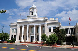 Davie County Courthouse, Courthouse Square, September 2013 | |
| Motto(s): "Time Well Spent" | |
 Location of Mocksville, North Carolina | |
| Coordinates: 35°53′38″N 80°33′41″W / 35.89389°N 80.56139°WCoordinates: 35°53′38″N 80°33′41″W / 35.89389°N 80.56139°W[1] | |
| Country | United States |
| State | North Carolina |
| County | Davie |
| Government | |
| • Mayor | William J. Marklin III[2] |
| Area | |
| • Total | 7.76 sq mi (20.10 km2) |
| • Land | 7.74 sq mi (20.05 km2) |
| • Water | 0.02 sq mi (0.05 km2) |
| Elevation | 860 ft (260 m) |
| Population (2010) | |
| • Total | 5,051 |
| • Estimate (2019)[4] | 5,252 |
| • Density | 678.29/sq mi (261.89/km2) |
| Time zone | UTC-5 (Eastern (EST)) |
| • Summer (DST) | UTC-4 (EDT) |
| ZIP code | 27028 |
| Area code(s) | 336 |
| FIPS code | 37-43720[5] |
| Website | mocksvillenc |
Mocksville is a town in Davie County, North Carolina, United States. The population was 5,051 at the 2010 census.[6] It is the county seat of Davie County.[7]
History[]
Mocksville was incorporated as a town in 1839.[8] The town was named for the original owner of the town site.[9]
George E. Barnhardt House, Boxwood Lodge, Cana Store and Post Office, Jesse Clement House, Cooleemee, Davie County Courthouse, Davie County Jail, Downtown Mocksville Historic District, Hinton Rowan Helper House, Hodges Business College, McGuire-Setzer House, North Main Street Historic District, and Salisbury Street Historic District are listed on the National Register of Historic Places.[10]
Geography and Geology[]
Mocksville is located south of the center of Davie County.[11] U.S. Routes 64 and 601 pass through the town, while U.S. Route 158 has its western terminus in the town center. US 64 leads east 19 miles (31 km) to Lexington and west 24 miles (39 km) to Statesville, while US 601 leads north 19 miles (31 km) to Yadkinville and south 17 miles (27 km) to Salisbury. US 158 leads northeast 26 miles (42 km) to Winston-Salem. Interstate 40 passes 3 miles (5 km) northwest of the center of town, with access from Exit 168 (US 64) and Exit 170 (US 601).
According to the United States Census Bureau, the town has a total area of 7.6 square miles (19.6 km2), of which 0.01 square miles (0.03 km2), or 0.17%, is water.[6]
Located in Mocksville is the Mocksville complex that is made up of metamorphosed and unmetamorphosed gabbros including Farmington Gabbro[12]
Demographics[]
| Historical population | |||
|---|---|---|---|
| Census | Pop. | %± | |
| 1860 | 710 | — | |
| 1870 | 300 | −57.7% | |
| 1880 | 562 | 87.3% | |
| 1900 | 745 | — | |
| 1910 | 1,063 | 42.7% | |
| 1920 | 1,146 | 7.8% | |
| 1930 | 1,503 | 31.2% | |
| 1940 | 1,607 | 6.9% | |
| 1950 | 1,909 | 18.8% | |
| 1960 | 2,379 | 24.6% | |
| 1970 | 2,529 | 6.3% | |
| 1980 | 2,637 | 4.3% | |
| 1990 | 3,399 | 28.9% | |
| 2000 | 4,178 | 22.9% | |
| 2010 | 5,051 | 20.9% | |
| 2019 (est.) | 5,252 | [4] | 4.0% |
| U.S. Decennial Census[13] | |||
2020 census[]
| Race | Number | Percentage |
|---|---|---|
| White (non-Hispanic) | 3,790 | 64.24% |
| Black or African American (non-Hispanic) | 834 | 14.14% |
| Native American | 16 | 0.27% |
| Asian | 58 | 1.15% |
| Pacific Islander | 1 | 0.02% |
| Other/Mixed | 305 | 5.17% |
| Hispanic or Latino | 886 | 15.02% |
As of the 2020 United States census, there were 5,900 people, 2,062 households, and 1,307 families residing in the town.
2000 census[]
As of the census[5] of 2000, there were 4,178 people, 1,627 households, and 1,067 families residing in the town. The population density was 607.2 people per square mile (234.5/km2). There were 1,781 housing units at an average density of 258.8 per square mile (99.9/km2). The racial makeup of the town was 76.14% White, 17.76% African American, 0.19% Native American, 0.67% Asian, 0.05% Pacific Islander, 3.83% from other races, and 1.36% from two or more races. Hispanic or Latino of any race were 8.07% of the population.
There were 1,627 households, out of which 30.4% had children under the age of 18 living with them, 46.7% were married couples living together, 14.6% had a female householder with no husband present, and 34.4% were non-families. 30.7% of all households were made up of individuals, and 14.8% had someone living alone who was 65 years of age or older. The average household size was 2.42 and the average family size was 2.97.
In the town, the population was well distributed by age, with 23.5% under the age of 18, 8.9% from 18 to 24, 27.7% from 25 to 44, 21.4% from 45 to 64, and 18.6% who were 65 years of age or older. The median age was 37 years. For every 100 females, there were 90.3 males. For every 100 females age 18 and over, there were 83.3 males.
The median income for a household in the town was $35,407, and the median income for a family was $42,357. Males had a median income of $31,540 versus $23,375 for females. The per capita income for the town was $18,703. About 9.3% of families and 12.6% of the population were below the poverty line, including 12.8% of those under age 18 and 14.3% of those age 65 or over.
Notable people[]
- Daniel Boone, lived near Mocksville 1750–66. His father, Squire Boone, Sr., was the Justice of the Peace for Mocksville. Squire Boone and his wife Sarah are buried in Mocksville's Joppa Cemetery.
- Clint Bowyer, NASCAR Driver, currently residing in Mocksville, originally from Emporia, Kansas
- Thomas Ferebee, bombardier on the Enola Gay during the bombing of Hiroshima
- Joe Gibbs, NFL coach, member of Pro Football Hall of Fame, and NASCAR team owner
- Bob Gosse, film producer and director
- Hinton Rowan Helper, abolitionist and author of The Impending Crisis of the South. His residence in Mocksville, Hinton Rowan Helper House, is now a monument.
- Julia C. Howard, member of the North Carolina General Assembly[15]
- Caleb Martin, NBA player
- Cody Martin, NBA player
- Whit Merrifield, MLB player[16]
References[]
- ^ a b c U.S. Geological Survey Geographic Names Information System: Mocksville, North Carolina
- ^ "Elected Officials". Mocksville NC. Retrieved 23 February 2021.
- ^ "2019 U.S. Gazetteer Files". United States Census Bureau. Retrieved July 27, 2020.
- ^ a b "Population and Housing Unit Estimates". United States Census Bureau. May 24, 2020. Retrieved May 27, 2020.
- ^ a b "U.S. Census website". United States Census Bureau. Retrieved 2008-01-31.
- ^ a b "Geographic Identifiers: 2010 Demographic Profile Data (G001): Mocksville town, North Carolina". U.S. Census Bureau, American Factfinder. Archived from the original on February 13, 2020. Retrieved November 30, 2015.
- ^ "Find a County". National Association of Counties. Retrieved 2011-06-07.
- ^ McAllister, Jane Satchell; Dotson, Debra Leigh (2009). Davie County. Arcadia Publishing. p. 9. ISBN 978-0-7385-6797-6.
- ^ Gannett, Henry (1905). The Origin of Certain Place Names in the United States. U.S. Government Printing Office. p. 211.
- ^ "National Register Information System". National Register of Historic Places. National Park Service. July 9, 2010.
- ^ "US Gazetteer files: 2010, 2000, and 1990". United States Census Bureau. 2011-02-12. Retrieved 2011-04-23.
- ^ Esawi, E. K. (January 2012). "The mafic and ultramafic rocks of the Mocksville complex of Central North Carolina: Petrogenetic and tectonic implications". Mineralogy and Petrology. 104 (1–2): 15–27. doi:10.1007/s00710-011-0180-8. ISSN 0930-0708.
- ^ "Census of Population and Housing". Census.gov. Retrieved June 4, 2015.
- ^ "Explore Census Data". data.census.gov. Retrieved 2021-12-20.
- ^ Representative Julia C. Howard. ncleg.gov. Retrieved December 14, 2020.
- ^ Whit Merrifield Stats. Baseball-Reference. Retrieved December 14, 2020.
- "The History of Mocksville." historicdowntownmocksville.com - Retrieved Oct. 8, 2013.
External links[]
Municipalities and communities of Davie County, North Carolina, United States | ||
|---|---|---|
| Towns |  | |
| CDPs | ||
| Other communities | ||
| ||
- County seats in North Carolina
- Towns in Davie County, North Carolina
- Populated places established in 1839
- Towns in North Carolina
- 1839 establishments in North Carolina