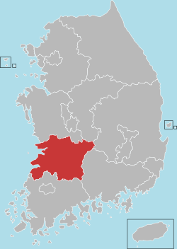
North Jeolla Province
This article needs additional citations for verification. (July 2021) |
North Jeolla Province
전라북도 | |
|---|---|
| Korean transcription(s) | |
| • Hangul | 전라북도 |
| • Hanja | 全羅北道 |
| • McCune‑Reischauer | Chŏllabuk-to |
| • Revised Romanization | Jeollabuk-do |
 Flag  Logo | |
 | |
| Country | South Korea |
| Region | Honam |
| Capital | Jeonju |
| Subdivisions | 6 cities; 8 counties |
| Government | |
| • Governor | Song Ha-jin (Democratic) |
| Area | |
| • Total | 8,067 km2 (3,115 sq mi) |
| Area rank | 7th |
| Population (December, 2015) | |
| • Total | 1,869,711 |
| • Density | 232/km2 (600/sq mi) |
| Metropolitan Symbols | |
| • Flower | Zinnia |
| • Tree | Ginkgo |
| • Bird | Magpie |
| ISO 3166 code | KR-45 |
| Dialect | Jeolla |
| Website | Official website (English) |
North Jeolla Province (Korean: 전라북도; Hanja: 全羅北道; Jeollabuk-do; ), also known as Jeonbuk, is a province of South Korea. North Jeolla has a population of 1,869,711 (2015) and has a geographic area of 8,067 km2 (3,115 sq mi) located in the Honam region in the southwest of the Korean Peninsula. North Jeolla borders the provinces of South Jeolla to the south, North Gyeongsang and South Gyeongsang to the east, North Chungcheong to the northeast, and South Chungcheong to the north.[citation needed]
Jeonju is the capital and largest city of North Jeolla, with other major cities including Iksan, Gunsan, and Jeongeup.
North Jeolla was established in 1896 from the province of Jeolla, one of the Eight Provinces of Korea, consisting of the northern half of its mainland territory.[citation needed]
History[]
During the Proto-Three Kingdoms period, Jeolla region was the center of the Mahan confederacy among Samhan. There were 15 tribal countries out of 54 in the region. During the period of the Three States, this region came to belong to Baekje when it absorbed Mahan. Baekje was destroyed by the Silla and Chinese Tang dynasty allied force in 660 (20th year of King Uija) and ruled by Tang. It became a part of Silla when Tang was expelled in 676 (16th year of King Munmu).
When there were nine states and five small capitals in Unified Silla in 685, there were Wansan-ju (present Jeonju) and Namwon-gyeong (present Namwon) in Jeollabuk-do in existence.
In 892, when General Gyeon Hwon founded Hubaekje (later Baekje), this area was the center of the country for about 50 years. In 936, during the rule of Singeom, it was attributed to Goryeo Dynasty. From 900 to the time when Hubaekje was attributed to Goryeo, Wansan-ju (present Jeonju) had been its capital, and the country ruled the whole Jeolla-do region.
In 996 (14th year of King Sungjong), this region was named Gangnam province and the Korean government established the four states (Jeonju-Jeonju, Yeongju-Gobu, Sunju-Sunchang, and Maju-Okgu) in the North Jeolla region.
Gangnam-do (Jeonbuk) and Haenam-do (Jeonnam) were combined and titled as Jeolla-do in 1018 (9th year of King Hyeonjong's reign).
During the Joseon Dynasty, as the administrative districts of the whole nation were organized in the Eight Provinces system in 1413 (13th year of King Taejong's reign), Jeolla-do took charge of vast areas of one prefecture, four autonomous counties, four protectorates, 12 counties, and 31 counties covering present Jeollanam-do, Jeollabuk-do and Jeju-do.
In 1896 (33rd year of King Gojong's reign), the whole country was divided into 13 provinces. Jeolla-do was divided into Jeollanam-do and Jeollabuk-do. Jeollabuk-do consisted of 26 counties.
In 1963, Geumsan-gun was incorporated into Chungnam, and Wido-myeon of Jeonnam was incorporated into Jeonbuk. Jeongju-eup and Namwon-eup were raised to cities in 1981 and Gimje-eup was raised to city status in 1989. Wansan-gu and Deokjin-gu were established in Jeonju-city in the same year.
Due to establishment of cities in the mixed type of city-farming area in 1995, Okgu, Jeungeup, Namwon, Gimje and Iksan-Guns were combined. Gimje and Iksan-guns were merged and Gunsan, Jeonju, Namwon, Gimje and Iri cities were integrated. Through repeated reorganizations of administrative districts, now the region consists of the administrative districts of six cities and eight counties.
Geography[]
Jeollabuk-do is in the south-western part of Korea, bordered on the south-eastern by Hadong-gun, Hamyang-gun, and Geochang-gun of Gyeongnam, and Gimcheon-si of Gyeongbuk, Bangyabong Peak of Sobaek Mountain (1,732 metres (5,682 ft)), Toggibong Peak (1,534 metres (5,033 ft)), Myeongseungbong Peak (1,586 metres (5,203 ft)), Baekwoonsan Mountain (1,279 metres (4,196 ft)), Namdeokyusan Mountain (1,508 metres (4,948 ft)), and Muyongsan Mountain (1,492 metres (4,895 ft)), on the south by Yeongwang-gun, Jangseong-gun, Damyang-gun, Gokseong-gun, and Gure-gun, on the north by Geumsan-gun, Nonsan-si, Buyeo -gun, and Seocheon-gun of Choongnam, and Yeongdong-gun of Choongbuk, and on the west by China over the Yellow Sea.
The total area of Jeollabuk-do is 8,067 square kilometres (3,115 sq mi), which accounts for 8.1% of the total area of South Korea.
Festivals[1][]
Jeonju International Sori Festival[]
Jeonju International Sori Festival is a high-quality worldwide music art festival based on Pansori, Korea's Intangible Cultural Heritage. It is designed to promote Korean music to the world and exchange diverse musical heritages of many nations though sounds as meditation. The festival was selected as one of the "Best 25 International Festivals" by the UK music magazine Songlines in 2012 and 2013.[2]
Jeollabuk-do World Calligraphy Biennale[]
The Jeollabuk-do World Calligraphy Biennale was launched in favor of popularizing and globalizing Korean calligraphy in 1997. Since then, the art of calligraphy, the quintessence of Chinese character culture in East Asia, has gained global interest among calligraphers and the public over the years.[3]
Transportation and industry[]
In the 1960s the Honam highway (which has been upgraded to the Honam Expressway) was built. This created an industrial belt, connecting the cities of Iri (now called Iksan) and Gunsan (a port city) with the provincial capital of Jeonju.
Public transportation networks serve Jeonju and other cities in Jeollabuk-do including Gunsan Airport.[4]
- Jeju International Airport → Gunsan Airport: twice a day / 50-minute flight
- Gunsan Airport → Jeonju: Airport shuttle service / 1 hour running
- Gunsan intercity bus service for other cities and counties
Education[]
National Universities with Graduate Schools[]
- Chonbuk National University - Jeonju
- Kunsan National University - Gunsan
- Jeonju National University of Education - Jeonju
Private Universities with Graduate Schools[]
- Howon University – Gunsan
- Jeonju University – Jeonju
- Woosuk University – Wanju County, Jeonju Campus
- Wonkwang University – Iksan
- – Iksan
- Yewon Arts University – Imsil County Campus
National Institutes of Higher Education[]
Private Institutes of Higher Education[]
Religion[]
Religion in North Jeolla (2005)
According to the census of 2005[5] of the people of North Jeolla 37.7% follow Christianity (26.3% Protestantism and 11.4% Catholicism) and 12.8% follow Buddhism. 49.5% of the population is mostly not religious or follow Muism and other indigenous religions.
International sisterhood relationships and partnerships[]
- Sisterhood relationship
 Jiangsu, People's Republic of China (27 October 1994)
 Washington, United States (17 May 1996)
- New Jersey, United States (19 May 2000)
- Partnership
 Kagoshima Prefecture, Japan (30 October 1989)
- Ishikawa Prefecture, Japan (10 September 2001)
- Shanghai, People's Republic of China (17 April 2003)
- Shandong, People's Republic of China (2 November 2006)
Administrative divisions[]
| Map | # | Name | Hangul | Hanja | Population (2016.12) | Subdivisions |
|---|---|---|---|---|---|---|

| ||||||
| — Specific City — | ||||||
| 1 | Jeonju | 전주시 | 全州市 | 651,744 | 2 ilban-gu — 33 haengjeong-dong | |
| — City — | ||||||
| 2 | Iksan | 익산시 | 益山市 | 300,479 | 1 eup, 14 myeon, 14 haengjeong-dong | |
| 3 | Gunsan | 군산시 | 群山市 | 277,551 | 1 eup, 10 myeon, 16 haengjeong-dong | |
| 4 | Jeongeup | 정읍시 | 井邑市 | 115,173 | 1 eup, 14 myeon, 8 haengjeong-dong | |
| 5 | Gimje | 김제시 | 金堤市 | 87,782 | 1 eup, 14 myeon, 4 haengjeong-dong | |
| 6 | Namwon | 남원시 | 南原市 | 84,188 | 1 eup, 15 myeon, 7 haengjeong-dong | |
| — County — | ||||||
| 7 | Wanju County | 완주군 | 完州郡 | 95,480 | 3 eup, 10 myeon | |
| 8 | Gochang County | 고창군 | 高敞郡 | 60,597 | 1 eup, 13 myeon | |
| 9 | Buan County | 부안군 | 扶安郡 | 57,005 | 1 eup, 12 myeon | |
| 10 | Sunchang County | 순창군 | 淳昌郡 | 29,949 | 1 eup, 10 myeon | |
| 11 | Imsil County | 임실군 | 任實郡 | 30,197 | 1 eup, 11 myeon | |
| 12 | Muju County | 무주군 | 茂朱郡 | 24,949 | 1 eup, 5 myeon | |
| 13 | Jinan County | 진안군 | 鎭安郡 | 26,069 | 1 eup, 10 myeon | |
| 14 | Jangsu County | 장수군 | 長水郡 | 23,628 | 1 eup, 6 myeon | |
Tourism[]
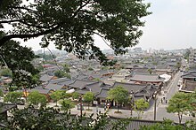

- Jeonju — Jeonju Hanok Village, Jeondong Catholic Church, Gyeonggijeon Shrine, Jeonju Hanji Museum, Royal Portrait Museum, Jeonju Gaeksa, Jeonjuhyanggyo Confucian School, Ajung Lake, Deokjin Park,
- Namwon — Gwanghallu Pavilion, Chunhyang Theme Park, Manin Cemetery of Righteous Fighters, Silsangsa Temple, Gyoryong Sanseong Fortress
- Gochang — Gochangeupseong Fortress, Seonunsa Temple, Pansori Museum
- Iksan — Mireuksaji Pagoda, Wanggungri Five-story Stone Pagoda
- Gimje — Geumsansa Temple
- Gunsan — Hirotsu House, Dongguksa Temple, Modern History Museum
- Buan — Tapsa Temple, Byeonsanbando National Park
- Imsil County — Imsil Cheese Village
See also[]
- Jeonbuk FC
- List of Korea-related topics
References[]
- ^ skoinfo. "Jeollabuk-do". en.jeonbuk.go.kr. Retrieved 18 March 2018.
- ^ "2018 전주세계소리축제 (2018.10.03~10.07)". www.sorifestival.com. Retrieved 18 March 2018.
- ^ 세계서예전북비엔날레. :: 세계서예전북비엔날레::. www.biennale.or.kr.
- ^ Official site http://en.jeonbuk.go.kr/index.jeonbuk?menuCd=DOM_000000204001000000
- ^ census 2005 http://www.census.go.kr/dat/ysr/ysrList.do?q_menu=5&q_sub=7
External links[]
 North Jeolla travel guide from Wikivoyage
- Official website (in English)
- North Jeolla Province news
- Travel Information
| show Places adjacent to North Jeolla Province |
|---|

Coordinates: 35°49′N 127°09′E / 35.817°N 127.150°E

| show Authority control |
|---|
- North Jeolla Province
- Provinces of South Korea