South Jeolla Province
This article needs additional citations for verification. (July 2021) |
Coordinates: 34°45′N 127°0′E / 34.750°N 127.000°E

South Jeolla Province
전라남도 | |
|---|---|
| Korean transcription(s) | |
| • Hangul | 전라남도 |
| • Hanja | 全羅南道 |
| • McCune‑Reischauer | Chŏllanam-do |
| • Revised Romanization | Jeollanam-do |
 Flag  Logo | |
 | |
| Country | South Korea |
| Region | Honam |
| Capital | Muan County |
| Subdivisions | 5 cities; 17 counties |
| Government | |
| • Governor | Kim Yung-rok (Democratic) |
| Area | |
| • Total | 12,247 km2 (4,729 sq mi) |
| Area rank | 3rd |
| Population (October, 2014) | |
| • Total | 1,902,324 |
| • Rank | 6th |
| • Density | 142/km2 (370/sq mi) |
| Metropolitan Symbols | |
| • Flower | Camellia japonica |
| • Tree | Ginkgo |
| • Bird | Oriental turtle dove |
| ISO 3166 code | KR-46 |
| Dialect | Jeolla |
| Website | Official website (English) |
South Jeolla Province (Korean: 전라남도; Hanja: 全羅南道; Jeollanam-do; ), also known as Jeonnam, is a province of South Korea. South Jeolla has a population of 1,902,324 (2014) and has a geographic area of 12,247 km2 (4,729 sq mi) located in the Honam region at the southwestern tip of the Korean Peninsula. South Jeolla borders the provinces of North Jeolla to the north, South Gyeongsang to the northeast, and Jeju to the southwest in the Korea Strait.[citation needed]
Muan County is the capital and Yeosu is the largest city of South Jeolla, with other major cities including Suncheon, Mokpo, and Gwangyang. Gwangju was the largest city of South Jeolla until becoming a Metropolitan City in 1986, and was the historic capital until the provincial government was relocated to the Muan County town of Namak in 2005.
South Jeolla was established in 1896 from the province of Jeolla, one of the Eight Provinces of Korea, consisting of the southern half of its mainland territory and most outlying islands.[citation needed]
Geography[]
The province is part of the Honam region, and is bounded on the west by the Yellow Sea, on the north by Jeollabuk-do Province, on the south by Jeju Strait, and on the east by Gyeongsangnam-do.
There are almost 2,000 islands along the coastline, about three quarters of which are uninhabited. The coastline is about 6,100 kilometres (3,800 mi) long. Some of the marine products, in particular oyster and seaweed cultivation, are leading in South Korea.
The province is only partially mountainous. The plains along the rivers Seomjin, Yeongsan and are suitable for large-scale grain agriculture. There is abundant rainfall in the area, which helps agriculture. The province is also home to the warmest weather on the peninsula. This helps to produce large amounts of agricultural produce, mainly rice, wheat, barley, pulses and potatoes. Vegetables, cotton and fruits are also grown in the province.
A small amount of gold and coal is mined in the province, but industries have also been developed in the area.
Administrative divisions[]
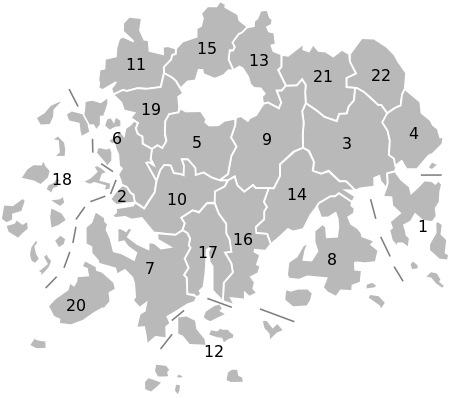
Jeollanam-do is divided into 5 cities (si) and 17 counties (gun). Listed below is the name of each entity in English, hangul, and hanja.


| Map | # | Name | Hangul | Hanja | Population (2012)[1] | Subdivisions |
|---|---|---|---|---|---|---|
| ||||||
| City | ||||||
| 1 | Yeosu | 여수시 | 麗水市 | 290,774 | 1 eup, 6 myeon, 20 haengjeong-dong | |
| 2 | Mokpo | ��포시 | 木浦市 | 238,368 | 23 haengjeong-dong | |
| 3 | Suncheon | 순천시 | 順天市 | 279,435 | 1 eup, 10 myeon, 13 haengjeong-dong | |
| 4 | Gwangyang | 광양시 | 光陽市 | 152,131 | 1 eup, 6 myeon, 5 haengjeong-dong | |
| 5 | Naju | 나주시 | 羅州市 | 100,312 | 1 eup, 12 myeon, 7 haengjeong-dong | |
| County | ||||||
| 6 | Muan County | 무안군 | 務安郡 | 71,294 | 3 eup, 6 myeon | |
| 7 | Haenam County | 해남군 | 海南郡 | 81,321 | 1 eup, 13 myeon | |
| 8 | Goheung County | 고흥군 | 高興郡 | 76,118 | 2 eup, 14 myeon | |
| 9 | Hwasun County | 화순군 | 和順郡 | 70,757 | 1 eup, 12 myeon | |
| 10 | Yeongam County | 영암군 | 靈巖郡 | 64,596 | 2 eup, 9 myeon | |
| 11 | Yeonggwang County | 영광군 | 靈光郡 | 58,026 | 3 eup, 8 myeon | |
| 12 | Wando County | 완도군 | 莞島郡 | 54 867 | 3 eup, 9 myeon | |
| 13 | Damyang County | 담양군 | 潭陽郡 | 48,329 | 1 eup, 11 myeon | |
| 14 | Boseong County | 보성군 | 寶城郡 | 49,940 | 2 eup, 10 myeon | |
| 15 | Jangseong County | 장성군 | 長城郡 | 47,231 | 1 eup, 10 myeon | |
| 16 | Jangheung County | 장흥군 | 長興郡 | 42,643 | 3 eup, 7 myeon | |
| 17 | Gangjin County | 강진군 | 康津郡 | 41,160 | 1 eup, 10 myeon | |
| 18 | Sinan County | 신안군 | 新安郡 | 46,007 | 2 eup, 12 myeon | |
| 19 | Hampyeong County | 함평군 | 咸平郡 | 37,528 | 1 eup, 8 myeon | |
| 20 | Jindo County | 진도군 | 珍島郡 | 34,486 | 1 eup, 6 myeon | |
| 21 | Gokseong County | 곡성군 | 谷城郡 | 32,896 | 1 eup, 10 myeon | |
| 22 | Gurye County | 구례군 | 求禮郡 | 27,765 | 1 eup, 7 myeon | |
Sister cities and provinces[]
 State of Arizona, United States
 State of Maryland, United States
 Gyeongsan, South Korea
 Ipswich, Queensland, Australia
 Bà Rịa-Vũng Tàu Province, Vietnam
 State of Oregon, United States[2]
 Sichuan Province, China
 Alcochete, Portugal[3]
Religion[]
Religion in South Jeolla (2005)[4]
According to the census of 2005, of the people of South Jeolla 30.5% follow Christianity (21.8% Protestantism and 8.7% Catholicism) and 16.1% follow Buddhism.[4] 53.4% of the population is mostly not religious or follow Muism and other indigenous religions.
Education[]
National universities with graduate schools[]
- Chonnam National University - Yeosu Campus
- Mokpo National Maritime University – Mokpo
- Mokpo National University - Mokpo/Muan County/Yeongam County
- Sunchon National University – Suncheon
Private universities with graduate schools[]
- Dongshin University – Naju
- Gwangju Catholic University – Naju
- Mokpo Catholic University – Mokpo
- Sehan University - Yeongam County Campus
- Youngsan Won Buddhist University – Yeonggwang County
- Chodang University – Muan County
- Hanlyo University – Gwangyang
Public institutes of higher education[]
Private institutes of higher education[]
- Chunnam Techno University – Gokseong County
- Dong-A College – Yeongam County
- Hanyeong College – Yeosu
- Koguryeo College - Naju
- – Gwangyang
- – Mokpo
- – Suncheon
- – Suncheon
List of governors of South Jeolla Province[]
- 31st: (July 1, 1995 – July 1, 1998) – 1st term
- 32nd: (July 1, 1998 – July 1, 2002) – 2nd term
- 33rd: (July 1, 2002 – April 29, 2004) – 1st term
- 34th: Park Jun-young (June 6, 2004 – July 1, 2006) – 1st term
- 35th: Park Jun-young (July 1, 2006 – July 1, 2010) – 2nd term
- 36th: Park Jun-young (July 1, 2010 – July 1, 2014) – 3rd term
- 37th: Lee Nak-yeon (July 1, 2014 – May 12, 2018)
- 38th: Kim Yung-rok (July 1, 2018 – )
Tourism[]

- Yeosu – Jinnamgwan Hall, Hyangiram, Yi Sun Shin Square
- Suncheon – Songgwangsa Temple, Seonamsa Temple, Nagan Eupseong Folk Village
- Mokpo – Mokpo Modern History Museum, Gatbawi Rock, Yudal Mountain
- Haenam – Ttanggut (End of the Land) Village, Mihwangsa Temple
- Gurye – Hwaeomsa Temple
- Damyang – Damyang Juknokwon, Metasequoia-lined Road, Soswaewon Garden
- Boseong – Boseong Green Tea Field Daehan Dawon
See also[]
- List of Korea-related topics
References[]
- ^ "Statistics". South Jeolla Province. Retrieved 2013-07-19.
- ^ "Background Brief on International Trade" (PDF). Archived from the original (PDF) on 2008-09-09. Retrieved 2008-07-21.
- ^ "Consulta".
- ^ Jump up to: a b "2005 Census - Religion Results". Archived from the original on 2015-09-04.
External links[]
| Wikimedia Commons has media related to Jeollanam-do. |
 South Jeolla travel guide from Wikivoyage
- Official website (in English)
| show Places adjacent to South Jeolla Province |
|---|

| show Authority control |
|---|
- South Jeolla Province
- Provinces of South Korea