Nugush (river)
| Nugush | |
|---|---|
 | |
| Native name | Нугуш (Russian) |
| Location | |
| Country | Russia |
| Physical characteristics | |
| Mouth | Belaya |
• coordinates | 53°04′32″N 55°59′43″E / 53.07556°N 55.99528°ECoordinates: 53°04′32″N 55°59′43″E / 53.07556°N 55.99528°E |
| Length | 235 km (146 mi) |
| Basin size | 3,820 km2 (1,470 sq mi) |
| Basin features | |
| Progression | Belaya→ Kama→ Volga→ Caspian Sea |

The Nugush (Russian: Нугуш, Nuguš; Bashkir: Нөгөш, Nögöş), also known as the Bolshoy Nugush (Russian: Большой Нугуш, Boljšoj Nuguš), is a river in Bashkortostan in Russia, a right tributary of the Belaya.[1] The river is 235 kilometres (146 mi) long, and its drainage basin covers 3,820 square kilometres (1,470 sq mi).[2] The Nugush freezes up in the first half of November and remains icebound until the second half of April.
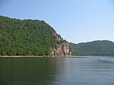
Nugush water reservoir storage[]


References[]
- ^ Нугуш, Great Soviet Encyclopedia
- ^ «Река НУГУШ», Russian State Water Registry
External links[]
This Bashkortostan location article is a stub. You can help Wikipedia by . |
This article related to a river in Russia is a stub. You can help Wikipedia by . |
Categories:
- Tributaries of the Belaya (Kama)
- Rivers of Bashkortostan
- Bashkortostan geography stubs
- Russia river stubs