Belaya (Kama)
This article needs additional citations for verification. (February 2014) |
| Agidel | |
|---|---|
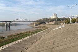 The Belaya in Ufa | |
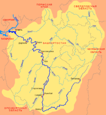 Belaya basin | |
 | |
| Location | |
| Country | Bashkortostan, Russia |
| Physical characteristics | |
| Source | |
| • location | Iremel mountain |
| • coordinates | 54°33′0″N 59°3′0″E / 54.55000°N 59.05000°E |
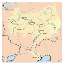
| Mouth | Kama, Nizhnekamsk Reservoir |
• coordinates | 55°53′14″N 53°36′14″E / 55.88722°N 53.60389°ECoordinates: 55°53′14″N 53°36′14″E / 55.88722°N 53.60389°E |
| Length | 1,430 km (890 mi) |
| Basin size | 142,000 km2 (55,000 sq mi) |
| Discharge | |
| • average | 858 m3/s (30,300 cu ft/s) (near Birsk) |
| Basin features | |
| Progression | Kama→ Volga→ Caspian Sea |

The Belaya (Russian: Бе́лая, romanized: Belaja; Bashkir: Ағиҙел, romanized: Ağiźel, lit. 'Ağiðel' [ä.ʁi̠.ˈðɪ̞l], ![]() pronunciation (help·info); Tatar: Агыйдел [ˌʌɣiˈdel]) is a river in Bashkortostan, Russian Federation. Its source lies in the south-western Ural Mountains.
pronunciation (help·info); Tatar: Агыйдел [ˌʌɣiˈdel]) is a river in Bashkortostan, Russian Federation. Its source lies in the south-western Ural Mountains.
It is 1,430 kilometres (890 mi) long, and its drainage basin covers 142,000 square kilometres (55,000 sq mi).[1][2]
Settlements along the Belaya include Beloretsk, Sterlitamak, Ufa (at the confluence with the river Ufa), and Birsk. The Belaya flows into the Kama near Neftekamsk.
Tributaries[]
The largest tributaries of the Belaya are, from source to mouth:[1]
References[]
- ^ Jump up to: a b «Река БЕЛАЯ», Russian State Water Registry
- ^ "Belaya River". Britannica.com. Retrieved 30 May 2016.
Gallery[]

The middle Belaya valley

The entrance to the Kapova Cave
The Belaya River in Ufa


| Wikimedia Commons has media related to Belaya River. |
| hide The river Kama | ||
|---|---|---|
Left tributary of the Volga | ||
| Tributaries |  | |
| Reservoirs | ||
| Hydroelectric stations |
| |
| Authority control |
|---|
This Bashkortostan location article is a stub. You can help Wikipedia by . |
This article related to a river in Russia is a stub. You can help Wikipedia by . |
- Tributaries of the Kama
- Rivers of Bashkortostan
- Bashkortostan geography stubs
- Russia river stubs