Ohio State Route 199
This article needs additional citations for verification. (December 2013) |
 | ||||
|---|---|---|---|---|
 | ||||
| Route information | ||||
| Maintained by ODOT | ||||
| Length | 62.160 mi[1] (100.037 km) | |||
| Existed | 1924–present | |||
| Major junctions | ||||
| South end | ||||
| North end | ||||
| Location | ||||
| Counties | Wyandot, Seneca, Wood | |||
| Highway system | ||||
| ||||
| ||||

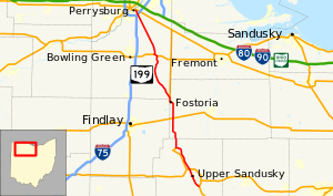
Ohio State Route 199 (SR 199) is a north-south highway in northwest Ohio. Its southern terminus is at an interchange with US 23 just south of Upper Sandusky, and its northern terminus is at US 20 and SR 795 in Perrysburg.
The route begins northerly into Upper Sandusky, and then on to Carey, where it joins US 23. The two routes run concurrently from Carey to Fostoria. From there, SR 199 continues to West Millgrove and to US 6, whose route it joins for a mile (1.6 km) as it crosses the Portage River. The route then continues north to Perrysburg.
History[]
Most of SR 199 was formerly the route of US 23. Before 1966, SR 199 was truncated at the south in Fostoria, followed most of the current route of US 23, and was truncated at the north just east of Toledo, Ohio. In 1966, SR 199 was extended along its current route to Upper Sandusky along US 23's current route from Fostoria to Carey and its old route from Carey to Upper Sandusky. In 1969, it switched routes with US 23 from Fostoria to Perrysburg.
Major intersections[]
| County | Location | mi[1] | km | Destinations | Notes |
|---|---|---|---|---|---|
| Wyandot | Pitt Township | 0.000 | 0.000 | Interchange | |
| Upper Sandusky | 4.342 | 6.988 | Southern end of SR 53 / SR 67 concurrency | ||
| 4.506 | 7.252 | Northern end of SR 53 / SR 67 concurrency | |||
| 7.053– 7.160 | 11.351– 11.523 | Interchange | |||
| Carey | 14.218 | 22.882 | Southern end of SR 103 concurrency | ||
| 15.401 | 24.786 | Northern end of SR 103 concurrency; southern end of US 23 concurrency; eastern terminus of SR 568 | |||
| Seneca | Loudon Township | 24.781 | 39.881 | ||
| Fostoria | 29.579– 29.588 | 47.603– 47.617 | Southern end of SR 18 concurrency | ||
| 30.093 | 48.430 | Southern end of SR 12 concurrency | |||
| 30.394– 30.465 | 48.914– 49.029 | Northern end of SR 12 concurrency | |||
| Seneca–Hancock county line | 30.918 | 49.758 | Northern end of SR 18 concurrency; eastern terminus of SR 613 | ||
| Seneca–Wood county line | 31.840 | 51.242 | Northern end of US 23 concurrency | ||
| Wood | Montgomery Township | 40.953 | 65.907 | ||
| Freedom Township | 46.313 | 74.534 | Southern end of US 6 concurrency | ||
| 47.284 | 76.096 | Northern end of US 6 concurrency | |||
| Webster Township | 50.188 | 80.770 | |||
| 54.420 | 87.581 | ||||
| Perrysburg | 62.160 | 100.037 | Western terminus of SR 795 | ||
1.000 mi = 1.609 km; 1.000 km = 0.621 mi
| |||||
References[]
Route map:

| ( • help)
|
- ^ a b "DESTAPE". Ohio Department of Transportation. July 3, 2014. Retrieved September 1, 2014.
- State highways in Ohio
- Transportation in Wood County, Ohio
- Transportation in Wyandot County, Ohio
- Transportation in Seneca County, Ohio
- U.S. Route 23