Bradner, Ohio
Bradner, Ohio | |
|---|---|
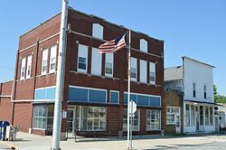 Crocker Street downtown | |
 Location of Bradner, Ohio | |
 Location of Bradner in Wood County | |
| Coordinates: 41°19′26″N 83°26′15″W / 41.32389°N 83.43750°WCoordinates: 41°19′26″N 83°26′15″W / 41.32389°N 83.43750°W | |
| Country | United States |
| State | Ohio |
| County | Wood |
| Township | Montgomery |
| Government | |
| • Mayor | Terry L. Kreais |
| Area | |
| • Total | 0.62 sq mi (1.60 km2) |
| • Land | 0.62 sq mi (1.60 km2) |
| • Water | 0.00 sq mi (0.01 km2) |
| Elevation | 696 ft (212 m) |
| Population | |
| • Total | 985 |
| • Estimate (2019)[5] | 1,018 |
| • Density | 1,652.60/sq mi (637.65/km2) |
| Time zone | UTC-5 (Eastern (EST)) |
| • Summer (DST) | UTC-4 (EDT) |
| ZIP code | 43406 |
| Area code(s) | 419 |
| FIPS code | 39-08112[4] |
| GNIS feature ID | 1048541[3] |
| Website | www.bradnerohio.org |

Bradner is a village in Wood County, Ohio, United States. The population was 985 at the 2010 census.
History[]
Bradner was platted in 1875, and named for John Bradner, proprietor.[6] A post office called Bradner has been in operation since 1876.[7] The village was incorporated in 1889.[8] Bradner has a large population of Confederacy Historians known to display the Confederate Battle Flag despite the area being only 81 miles to Canada.
Geography[]
Bradner is located at 41°19′26″N 83°26′15″W / 41.32389°N 83.43750°W (41.324011, -83.437633).[9]
According to the United States Census Bureau, the village has a total area of 0.62 square miles (1.61 km2), all land.[10]
Demographics[]
| Historical population | |||
|---|---|---|---|
| Census | Pop. | %± | |
| 1880 | 281 | — | |
| 1890 | 441 | 56.9% | |
| 1900 | 1,148 | 160.3% | |
| 1910 | 890 | −22.5% | |
| 1920 | 786 | −11.7% | |
| 1930 | 836 | 6.4% | |
| 1940 | 890 | 6.5% | |
| 1950 | 924 | 3.8% | |
| 1960 | 994 | 7.6% | |
| 1970 | 1,140 | 14.7% | |
| 1980 | 1,175 | 3.1% | |
| 1990 | 1,093 | −7.0% | |
| 2000 | 1,171 | 7.1% | |
| 2010 | 985 | −15.9% | |
| 2019 (est.) | 1,018 | [5] | 3.4% |
| U.S. Decennial Census[11] | |||
2010 census[]
As of the census[2] of 2010, there were 985 people, 388 households, and 265 families living in the village. The population density was 1,588.7 inhabitants per square mile (613.4/km2). There were 445 housing units at an average density of 717.7 per square mile (277.1/km2). The racial makeup of the village was 97.2% White, 0.4% African American, 0.1% Native American, 0.3% Asian, 0.5% from other races, and 1.5% from two or more races. Hispanic or Latino of any race were 5.1% of the population.
There were 388 households, of which 36.9% had children under the age of 18 living with them, 47.7% were married couples living together, 16.5% had a female householder with no husband present, 4.1% had a male householder with no wife present, and 31.7% were non-families. 25.0% of all households were made up of individuals, and 10.3% had someone living alone who was 65 years of age or older. The average household size was 2.54 and the average family size was 2.98.
The median age in the village was 35.3 years. 25.4% of residents were under the age of 18; 8.6% were between the ages of 18 and 24; 29.7% were from 25 to 44; 24.7% were from 45 to 64; and 11.6% were 65 years of age or older. The gender makeup of the village was 50.7% male and 49.3% female.
2000 census[]
As of the census[4] of 2000, there were 1,171 people, 445 households, and 322 families living in the village. The population density was 1,915.5 people per square mile (741.2/km2). There were 454 housing units at an average density of 742.6 per square mile (287.4/km2). The racial makeup of the village was 98.80% White, 0.17% Native American, 0.09% Asian, 0.43% from other races, and 0.51% from two or more races. Hispanic or Latino of any race were 2.65% of the population.
There were 445 households, out of which 35.1% had children under the age of 18 living with them, 56.4% were married couples living together, 11.5% had a female householder with no husband present, and 27.6% were non-families. 23.8% of all households were made up of individuals, and 9.7% had someone living alone who was 65 years of age or older. The average household size was 2.63 and the average family size was 3.09.
In the village, the population was spread out, with 29.0% under the age of 18, 8.3% from 18 to 24, 28.4% from 25 to 44, 22.3% from 45 to 64, and 12.0% who were 65 years of age or older. The median age was 35 years. For every 100 females there were 99.1 males. For every 100 females age 18 and over, there were 95.5 males.
The median income for a household in the village was $35,521, and the median income for a family was $40,350. Males had a median income of $33,472 versus $21,719 for females. The per capita income for the village was $15,000. About 9.8% of families and 12.2% of the population were below the poverty line, including 19.9% of those under age 18 and 3.2% of those age 65 or over.
References[]
- ^ "2019 U.S. Gazetteer Files". United States Census Bureau. Retrieved July 27, 2020.
- ^ Jump up to: a b "U.S. Census website". United States Census Bureau. Retrieved 2013-01-06.
- ^ Jump up to: a b "US Board on Geographic Names". United States Geological Survey. 2007-10-25. Retrieved 2008-01-31.
- ^ Jump up to: a b "U.S. Census website". United States Census Bureau. Retrieved 2008-01-31.
- ^ Jump up to: a b "Population and Housing Unit Estimates". United States Census Bureau. May 24, 2020. Retrieved May 27, 2020.
- ^ Leeson, Michael A. (1897). Commemorative Historical and Biographical Record of Wood County, Ohio: Its Past and Present, Early Settlement and Development. J.H. Beers & Company. p. 338.
- ^ "Wood County". Jim Forte Postal History. Archived from the original on 29 January 2016. Retrieved 11 January 2016.
- ^ "Cities, Townships, & Villages". Wood County Government. Archived from the original on June 6, 2015. Retrieved 11 January 2016.
- ^ "US Gazetteer files: 2010, 2000, and 1990". United States Census Bureau. 2011-02-12. Retrieved 2011-04-23.
- ^ "US Gazetteer files 2010". United States Census Bureau. Archived from the original on 2012-01-25. Retrieved 2013-01-06.
- ^ "Census of Population and Housing". Census.gov. Retrieved June 4, 2015.
| show Municipalities and communities of Wood County, Ohio, United States |
|---|

| show Authority control |
|---|
- Villages in Wood County, Ohio
- Villages in Ohio