Scotch Ridge, Ohio
Scotch Ridge, Ohio | |
|---|---|
 The former Scotch Ridge United Presbyterian Church | |
 Scotch Ridge, Ohio | |
| Coordinates: 41°24′09.147″N 83°31′23.1312″W / 41.40254083°N 83.523092000°WCoordinates: 41°24′09.147″N 83°31′23.1312″W / 41.40254083°N 83.523092000°W | |
| Country | United States |
| State | Ohio |
| County | Wood |
| Elevation | 659 ft (201 m) |
| Time zone | UTC-5 (Eastern (EST)) |
| • Summer (DST) | UTC-4 (EDT) |
| Area code(s) | 419 & 567 |

Scotch Ridge is an unincorporated community in Wood County, Ohio, United States.[2][3] It is part of Webster Township and located at the intersection of OH 199 and OH 105.
Scotch Ridge is part of the Eastwood Local School District.
A post office called Scotch Ridge was established in 1850, and remained in operation until 1926.[4] The community derives its name from Scotland, the ancestral home of a large share of the first settlers.[5]
Gallery[]
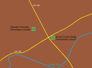
General vicinity of Scotch Ridge, Ohio

Notes[]
- ^ "Search". Google Maps. Retrieved 12 January 2016.
- ^ "Scotch Ridge, Ohio". Geographic Names Information System. United States Geological Survey.
- ^ Scotch Ridge, Ohio-Ohio Hometown Locator
- ^ "Post offices". Jim Forte Postal History. Retrieved 19 June 2016.
- ^ Overman, William Daniel (1958). Ohio Town Names. Akron, OH: Atlantic Press. p. 124.
| show Municipalities and communities of Wood County, Ohio, United States |
|---|

| show Authority control |
|---|
This Wood County, Ohio state location article is a stub. You can help Wikipedia by . |
Categories:
- Unincorporated communities in Wood County, Ohio
- Unincorporated communities in Ohio
- Northwest Ohio geography stubs