Old Zionsville, Pennsylvania
This article needs additional citations for verification. (May 2017) |
Old Zionsville, Pennsylvania | |
|---|---|
Unincorporated community | |
 | |
 Old Zionsville | |
| Coordinates: 40°29′11″N 75°31′13″W / 40.48639°N 75.52028°WCoordinates: 40°29′11″N 75°31′13″W / 40.48639°N 75.52028°W | |
| Country | United States |
| State | Pennsylvania |
| County | Lehigh |
| Township | Upper Milford |
| Elevation | 778 ft (237 m) |
| Time zone | UTC-5 (Eastern (EST)) |
| • Summer (DST) | UTC-4 (EDT) |
| ZIP code | 18068 |
| Area code(s) | 610 & 484 |
| GNIS feature ID | 1182959[1] |
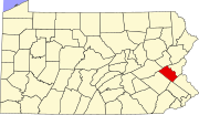
Old Zionsville is an unincorporated community in Upper Milford Township, Pennsylvania, in the United States. Old Zionsville is located along Pennsylvania Route 29 and Pennsylvania Route 100 2.5 miles (4.0 km) southeast of Macungie. Old Zionsville has a box post office with ZIP code 18068.[2] Surrounding areas use the Zionsville ZIP code of 18092 or the Emmaus ZIP code of 18049.[3]
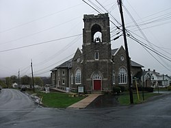
The Upper Milford Township municipal building is located at 5671 Chestnut Street at the former site of Kings Highway Elementary School and has a Saturday farmers' market. There are two churches of the Lutheran and UCC faiths in the village and two more of the Mennonite and Bible Fellowship faiths within a mile to the east near Zionsville.
Old Zionsville straddles the divide between the Lehigh and Schuylkill River watersheds. While most of the village is drained via headwaters of Perkiomen Creek to the Schuylkill River, the northern tier including the municipal building is drained via Leibert Creek and Little Lehigh Creek to the Lehigh River. The watershed divide runs east-to-west just north of Ridgeway Drive and Walnut Lane.
Education[]
The community is served by the East Penn School District. Emmaus High School serves grades nine through 12. Eyer Middle School and Lower Macungie Middle School serve grades six through eight.
References[]
| Wikimedia Commons has media related to Old Zionsville, Pennsylvania. |
- Unincorporated communities in Lehigh County, Pennsylvania
- Unincorporated communities in Pennsylvania
- Pennsylvania geography stubs


