Olecko
Olecko | |
|---|---|
| |
 Flag 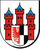 Coat of arms | |
 Olecko | |
| Coordinates: 54°2′N 22°30′E / 54.033°N 22.500°E | |
| Country | |
| Voivodeship | |
| County | Olecko County |
| Gmina | Gmina Olecko |
| Established | 16th century |
| Town rights | 1560 |
| Government | |
| • Mayor | Karol Sobczak |
| Area | |
| • Total | 11.6 km2 (4.5 sq mi) |
| Population (2011) | |
| • Total | 22,384 |
| • Density | 1,900/km2 (5,000/sq mi) |
| Time zone | UTC+1 (CET) |
| • Summer (DST) | UTC+2 (CEST) |
| Postal code | 19-400 to 19-402 |
| Area code(s) | +48 87 |
| Car plates | NOE, NOG |
| Website | http://www.olecko.pl |


Olecko [ɔˈlɛt͡skɔ] (former German: ![]() Marggrabowa (help·info) since 1560, colloquially also
Marggrabowa (help·info) since 1560, colloquially also ![]() Oletzko (help·info),
Oletzko (help·info), ![]() Treuburg (help·info) since 1928, Lithuanian: Alėcka) is a town in northeastern Poland, in the Warmian-Masurian Voivodeship, located in Masuria near Ełk and Suwałki. It is situated at the mouth of the Lega river which flows into the (Jezioro Oleckie Wielkie) on its south-western shore. Olecko is the seat of Olecko County.
Treuburg (help·info) since 1928, Lithuanian: Alėcka) is a town in northeastern Poland, in the Warmian-Masurian Voivodeship, located in Masuria near Ełk and Suwałki. It is situated at the mouth of the Lega river which flows into the (Jezioro Oleckie Wielkie) on its south-western shore. Olecko is the seat of Olecko County.
History[]

Marggrabowa was founded as a town by Albert, Duke of Prussia, a vassal of Poland, on January 1, 1560, who gave it a Polish rather than German name.[1] The town's first wójt was Adam Wojdowski[2] The town's name was derived from the word Margrabia (Polish for Margrave), the duke's title as the margraviate of Brandenburg-Ansbach's prince, by adding the suffix "-owa", which is typical in Poland for place names derived from personal names and titles. The town's coat of arms still reflects the Brandenburg red eagle and the Hohenzollern black and white which go back to Duke Albert. The populace became Lutheran-Protestant within the Duchy of Prussia in 1525. The almost entirely Polish population of the town used the Polish name Olecko.[3]
At the same location as the present location of the town there has been a hunting lodge called Olecko since 1544. At a peninsula towards the lake, across the Lega river, in 1619 the Castle of Olecko (Schloss Oletzko) was established as a regional administrative seat for the Dukes of Prussia.
The town remained under Polish suzerainty until 1657 when the Duchy of Prussia became independent. In 1701 it was part of the Kingdom of Prussia, and subsequently, in 1871, a part of German Empire.In 1807 Polish soldiers under command of Jan Henryk Dąbrowski were stationed in the town during Napoleon's campaign against Prussia and developed friendly relations with the inhabitants.It was believed that both the town and most of Masuria region will again be part of Polish state, with local population expressing support against Prussian rule.[4] Between 1818 and 1945, Marggrabowa was the seat of Oletzko County (Kreis Oletzko) in the province of East Prussia. In 1825 half of the inhabitants of the town didn't use the German language, during the second half of the 19th century Germanization made significant encroachments.[5] In 1836 the local priesthood organized a synod in Olecko in which it protested against Germanization measures aimed at local population[6]
20th century[]
After Poland regained its independence (1918), in 1920 a plebiscite was to be held in the area by the League of Nations according to the Treaty of Versailles, to determine the future of the region and the town. In Olecko German militia has attacked and beaten local Polish activists, while local Polish House was demolished. The Allied representatives didn't react to acts of German terror in the city, only after several pleas they asked for intervention to protect Poles, however to do so they brought a unit of German border guard. On 11th of August 1920 a German mob went through the town chanting anti-Polish slogans, including "destroy Polonia!" and demanding destruction of houses belonging to "Polish agents"; in view of the attacks and overall situation many Polish supporters boycotted the plebiscite considering it a farce[7]The plebiscite resulted in 3,903 votes for Germany and none for Poland.[8] As a result, the town was renamed Treuburg (lit.: loyal castle) in 1928.
After World War II the town was placed under Polish administration, under territorial changes preliminarily agreed upon at the Potsdam Conference. The pre-war native populace was displaced.
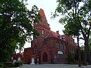
Sights[]

In the northern part of the town's market square, a Catholic church is situated on a tree-covered hill.
Transport[]
The Train Station in the western part of town is a regional railway junction: there were main lines to Gołdap, Ełk and Suwałki. The local railway connections to Mieruniszki, Kruklanki and Sulejki are out of service or dismantled. Currently only bus service runs from the train station.
Education[]
Notable residents[]
- Gustav Bergenroth (1813-1869), German historian
- Kurt Blumenfeld (1884–1963), Zionist
- Arthur Zimmermann (1864–1940), diplomat, author of the Zimmermann Telegram
- Bartosz Romańczuk (born 1983), Polish footballer
International relations[]
Twin towns — sister cities[]
Olecko is twinned with:
 Jõhvi, Estonia
References[]
- ^ Olecko. Z dziejów miasta i powiatu, by Andrzej Wakar,page 75, Pojezierze 1974
- ^ Prace Białostockiego Towarzystwa Naukowego, Issue 21 Białostockie Towarzystwo Naukowe Państwowe Wydawnictwo Naukowe, page 227, 1975
- ^ Słownik geograficzny Królestwa Polskiego i innych krajów słowiańskich, Tom VI, Warsaw, 1885, p. 114, 116 (in Polish)
- ^ Olecko. Z dziejów miasta i powiatu, by Andrzej Wakar,page 75, Pojezierze 1974
- ^ Zabytkowe ośrodki miejskie Warmii i Mazur Lucjan Czubiel, Tadeusz Domagała Pojezierze,page 229, 1969
- ^ Olecko. Z dziejów miasta i powiatu, by Andrzej Wakar,page 125-127, Pojezierze 1974
- ^ Olecko. Z dziejów miasta i powiatu, by Andrzej Wakar,page 151, Pojezierze 1974
- ^ Marzian, Herbert; Kenez, Csaba (1970). Selbstbestimmung für Ostdeutschland – Eine Dokumentation zum 50 Jahrestag der ost- und westpreussischen Volksabstimmung am 11. Juli 1920 (in German). p. 65.
External links[]
- Municipal website of Olecko (en)(pl)
- Website of Olecko (pl)
- iOlecko - news, events, history, photos from Olecko (pl)
| Wikimedia Commons has media related to Olecko. |
Coordinates: 54°02′N 22°30′E / 54.033°N 22.500°E

| show Authority control |
|---|
- Cities and towns in Warmian-Masurian Voivodeship
- Olecko County