Oskol (river)
| Oskol | |
|---|---|
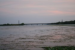 Oskil near Kruhliakivka | |
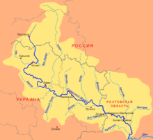 Donets river basin. The Oskol is the northernmost tributary | |
| Native name | |
| Location | |
| Country | Russia, Ukraine |
| Physical characteristics | |
| Mouth | Donets |
• coordinates | 49°05′19″N 37°22′42″E / 49.0885°N 37.3782°ECoordinates: 49°05′19″N 37°22′42″E / 49.0885°N 37.3782°E |
| Length | 472 km (293 mi) |
| Basin size | 14,800 km2 (5,700 sq mi) |
| Basin features | |
| Progression | Donets→ Don→ Sea of Azov |

The Oskol (Russian: Оскол) or Oskil (Ukrainian: Оскiл) is a south-flowing river in Russia and Ukraine. It arises roughly between Kursk and Voronezh and flows south to join the Seversky Donets which flows southeast to join the Don. It is 472 kilometres (293 mi) long, with a drainage basin of 14,800 square kilometres (5,700 sq mi).[1]
The river has its sources on the Central Russian Uplands, and flows through Kursk and Belgorod Oblasts in Russia, and through the eastern part of Kharkiv Oblast in Ukraine, where it joins the Seversky Donets river. An artificial lake, the Oskol Reservoir (Oskil Reservoir, Оскільське водосховище), was created in 1958 to help with flood protection and as a source of electricity.
There are several towns along the Oskol: Stary Oskol, Novy Oskol and Valuyki in Russia, and Kupiansk in Ukraine.
References[]
- ^ «Река Оскол», Russian State Water Registry
External links[]
This Belgorod Oblast location article is a stub. You can help Wikipedia by . |
This Kursk Oblast location article is a stub. You can help Wikipedia by . |
This article about a location in Kharkiv Oblast is a stub. You can help Wikipedia by . |
This article related to a river in Russia is a stub. You can help Wikipedia by . |
- Tributaries of the Donets
- Rivers of Belgorod Oblast
- Rivers of Kursk Oblast
- Rivers of Kharkiv Oblast
- International rivers of Europe
- Belgorod Oblast geography stubs
- Kursk Oblast geography stubs
- Kharkiv Oblast geography stubs
- Russia river stubs
- Ukraine river stubs