Kharkiv Oblast
Kharkiv Oblast
Харківська область Kharkivs’ka oblast’ | |
|---|---|
| Kharkivska oblast[1] | |
 Flag  Coat of arms | |
| Nickname(s): Харківщина (Kharkivshchyna) | |
 | |
| Coordinates: 49°35′N 36°26′E / 49.59°N 36.43°ECoordinates: 49°35′N 36°26′E / 49.59°N 36.43°E | |
| Country | |
| Administrative center | Kharkiv |
| Government | |
| • Governor | Oleksandr Skakun (acting)[2] |
| • Oblast council | 120 seats |
| Area | |
| • Total | 31,415 km2 (12,129 sq mi) |
| Area rank | Ranked 4th |
| Population (2021)[3] | |
| • Total | |
| • Rank | Ranked 3rd |
| Demographics | |
| • Official language(s) | Ukrainian |
| Time zone | UTC+2 (EET) |
| • Summer (DST) | UTC+3 (EEST) |
| Postal code | ? |
| Area code | +380-57 |
| ISO 3166 code | UA-63 |
| Vehicle registration | AX |
| Raions | 7[4] |
| Cities (total) | 17 |
| • Regional cities | 7 |
| Urban-type settlements | 61 |
| Villages | 1683 |
| FIPS 10-4 | UP07 |
| Website | www.kharkivoda.gov.ua |

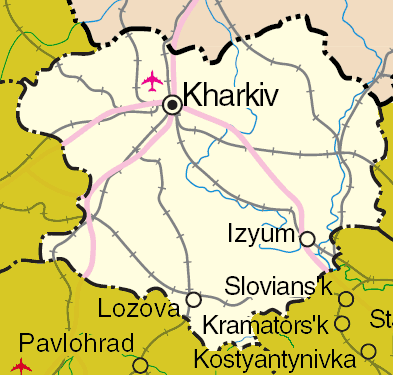
Kharkiv Oblast (Ukrainian: Харківська область, romanized: Kharkivska oblast, also referred to as Kharkivshchyna, Харківщина; Russian: Харьковская область) is an oblast (province) in eastern Ukraine. The oblast borders Russia to the north, Luhansk Oblast to the east, Donetsk Oblast to the south-east, Dnipropetrovsk Oblast to the south-west, Poltava Oblast to the west and Sumy Oblast to the north-west. The area of the oblast is 31,400 km², corresponding to 5.2% of the total territory of Ukraine. Population: 2,633,834 (2021 est.)[3]
The oblast is the third most populous province of Ukraine, with a population of 2,857,751 in 2004, more than half (1.5 million) of whom live in the city of Kharkiv, the oblast's administrative center. While the Russian language is primarily spoken in the cities of Kharkiv oblast, elsewhere in the oblast most inhabitants speak Ukrainian.
Geography[]
The oblast borders Russia (Belgorod Oblast) to the north, Luhansk Oblast to the east, Donetsk Oblast to the south-east, Dnipropetrovsk Oblast to the south-west, Poltava Oblast to the west and Sumy Oblast to the north-west.
History[]
During the , in 1925, the Kharkov Governorate was abolished leaving its five okruhas: Okhtyrka (originally Bohodukhiv), Izyum, Kupyansk, Sumy, and Kharkiv. Introduced in the Soviet Union in 1923, a similar subdivisions existed in Ukraine back in 1918. In 1930 all okruhas were also abolished with raions becoming the first level of subdivision of Ukraine until 1932.
The modern Kharkiv Oblast was established on 27 February 1932. In summer of 1932, some parts of the oblast were included in the newly created Donetsk Oblast originally centered in Artemivsk (later in Stalino). Then in the fall, some territories of the Kharkiv Oblast were used in creation of Chernihiv Oblast. More territories became part of Poltava Oblast in fall of 1937 and Sumy Oblast in winter of 1939.
During the Holodomor the population of the Kharkiv Oblast together with Kyiv Oblast suffered the most. The region saw major fighting during World War II in several Battles of Kharkov between 1941 and 1943.
During the 1991 referendum, 86.33% of votes in Kharkiv Oblast were in favor of the Declaration of Independence of Ukraine. A survey conducted in December 2014 by the Kyiv International Institute of Sociology found 4.2% of the oblast's population supported their region joining Russia, 71.5% did not support the idea, and the rest were undecided or did not respond.[5]
Points of interest[]
The following sites were nominated for the Seven Wonders of Ukraine.
- Derzhprom Building
- Pokrov monastery (Kharkiv)
Demographics[]
Its population in 2001 was 2,895,800 million (1,328,900 males (45.9%) and 1,566,900 females (54.1%)).
At the 2001 census, the ethnic groups within the Kharkiv Oblast were:
- Ukrainians – 70.7%,
- Russians – 25.6%,
- Belorussians – 0.5%
- Jews – 0.4%,
- Armenians – 0.4%,
- Azeris – 0.2%,
- Georgians – 0.15%,
- Tatars – 0.14%,
- others – 2.1%,;
the groups by native language:
- Ukrainian 53.8%,
- Russian 44.3%,
- other languages 1.9%.
Age structure[]
- 0-14 years: 12.6%
 (male 177,464/female 167,321)
 - 15-64 years: 72.2%
 (male 945,695/female 1,024,841)
 - 65 years and over: 15.2%
 (male 135,737/female 277,725) (2013 official)
Median age[]
- total: 40.5 years
- male: 36.9 years
- female: 44.1 years (2013 official)
Economy[]
The Kharkiv oblast has a primarily industrially based economy, including engineering, metallurgy, manufacturing, production of chemicals and food processing. It also has an important agricultural sector with 19,000 square kilometres of arable land (comprising 5.9% of the total arable lands of Ukraine). Agricultural production grew substantially in 2015.[6]
Also in Kharkiv is the Airplane plant for space controlling systems. It is a major center for all branches of engineering, from large-scale manufacture to microelectronics. Also situated in Kharkiv Oblast is a gas field, which is one of the biggest in Ukraine.
Administrative divisions[]
The Kharkiv Oblast is administratively subdivided into 7[4] raions (districts) (prior to 2020 decentralization reform this number was 25[4]), as well as 7 cities (municipalities) which are directly subordinate to the oblast government: Chuhuiv, Izium, Kupiansk, Liubotyn, Lozova, Pervomaiskyi, and the administrative center of the oblast, Kharkiv.
| Name | Ukrainian name | Area (km2) |
Population census 2015[7] |
Admin.center | Urban Population Only |
|---|---|---|---|---|---|
| Kharkiv | Харків (місто) | 350 | 1,449,674 | Kharkiv (city) | 1,449,674 |
| Chuhuiv | Чугуїв (місто) | 13 | 33,243 | Chuhuiv (city) | 32,401 |
| Izium | Ізюм (місто) | 44 | 49,822 | Izium (city) | 49,822 |
| Kupiansk | Ку́п'янськ (місто) | 33 | 56,704 | Kupiansk (city) | 56,704 |
| Liubotyn | Люботин (місто) | 31 | 24,442 | Liubotyn (city) | 21,619 |
| Lozova | Лозова́ (місто) | 18 | 65,950 | Lozova (city) | 64,269 |
| Pervomaiskyi | Первомайський (місто) | 15 | 30,616 | Pervomaiskyi (city) | 30,616 |
| Balakliys'kyi raion | Балаклійський район | 1,986 | 82,003 | Balakliia | 51,886 |
| Barvinkivs'kyi raion | Барвінківський район | 1,364 | 21,919 | Barvinkove | 9,057 |
| Blyzniukivs'kyi raion | Близнюківський район | 1,380 | 19,144 | Blyzniuky | 3,790 |
| Bohodukhivs'kyi raion | Богодухівський район | 1,160 | 39,182 | Bohodukhiv | 18,998 |
| Borivs'kyi raion | Борівський район | 875 | 16,938 | 5,624 | |
| Chuhuivs'kyi raion | Чугуївський район | 1,148 | 46,579 | Chuhuiv (city) | N/A * |
| Derhachivs'kyi raion | Дергачівський район | 900 | 95,122 | Derhachi | 67,908 |
| Dvorichans'kyi raion | Дворічанський район | 1,112 | 17,775 | Dvorichna | 3,669 |
| Iziums'kyi raion | Ізюмський район | 1,553 | 17,382 | Izium (city) | N/A * |
| Kehychivs'kyi raion | Кегичівський район | 782 | 21,058 | Kehychivka | 8,799 |
| Kharkivs'kyi raion | Харківський район | 1,403 | 182,239 | Kharkiv | N/A * |
| Kolomats'kyi raion | Коломацький район | 330 | 7,099 | Kolomak | 2,919 |
| Krasnohrads'kyi raion | Красноградський район | 985 | 44,742 | Krasnohrad | 21,008 |
| Krasnokuts'kyi raion | Краснокутський район | 1,040 | 28,260 | Krasnokutsk | 8,895 |
| Kupyans'kyi raion | Куп'янський район | 1,280 | 24,769 | Kupiansk (city) | N/A * |
| Lozivs'kyi raion | Лозівський район | 1,403 | 29,139 | Lozova (city) | N/A * |
| Novovodolaz'kyi raion | Нововодолазький район | 1,182 | 33,175 | Nova Vodolaha | 11,850 |
| Pecheniz'kyi raion | Печенізький район | 467 | 10,113 | Pechenihy | 5,340 |
| Pervomais'kyi raion | Первомайський район | 1,225 | 16,027 | Pervomaiskyi (city) | N/A * |
| Sakhnovshchyns'kyi raion | Сахновщинський район | 1,170 | 21,377 | Sakhnovshchyna | 7,333 |
| Shevchenkivs'kyi raion | Шевченківський район | 977 | 20,480 | Shevchenkove | 6,957 |
| Valkivs'kyi raion | Валківський район | 1,011 | 31,897 | Valky | 14,174 |
| Velykoburluts'kyi raion | Великобурлуцький район | 1,221 | 22,541 | Velykyi Burluk | 6,049 |
| Vovchans'kyi raion | Вовчанський район | 1,888 | 47,172 | Vovchansk | 28,143 |
| Zachepylivs'kyi raion | Зачепилівський район | 794 | 15,329 | Zachepylivka | 3,642 |
| Zmiyivs'kyi raion | Зміївський район | 1,365 | 71,887 | Zmiiv | 33,366 |
| Zolochivs'kyi raion | Золочівський район | 969 | 26,543 | 8,916 |
Note: Asterisks (*) Though the administrative center of the rayon is housed in the city/town that it is named after, cities do not answer to the rayon authorities only towns do; instead they are directly subordinated to the oblast government and therefore are not counted as part of rayon statistics.
Nomenclature[]
Most of Ukraine's oblasts are named after their capital cities, officially called "oblast centers" (Ukrainian: обласний центр, translit. oblasnyi tsentr). The name of each oblast is a relative adjective, formed by adding a feminine suffix to the name of respective center city: Kharkiv is the center of the Kharkivs’ka oblast’ (Kharkiv Oblast). Most oblasts are also sometimes referred to in a feminine noun form, following the convention of traditional regional place names, ending with the suffix "-shchyna", as is the case with the Kharkiv Oblast, Kharkivshchyna.
Sport[]

It has a regional federation within Ukrainian Bandy and Rink bandy Federation.[1]
References[]
- ^ Syvak, Nina; Ponomarenko, Valerii; Khodzinska, Olha; Lakeichuk, Iryna (2011). Veklych, Lesia (ed.). "Toponymic Guidelines for Map and Other Editors for International Use" (PDF). United Nations Statistics Division. scientific consultant Iryna Rudenko; reviewed by Nataliia Kizilowa; translated by Olha Khodzinska. Kyiv: DerzhHeoKadastr and Kartographia. p. 20. ISBN 978-966-475-839-7. Retrieved 2020-10-06.
- ^ President appoints acting chairman of Kharkiv Regional State Administration, Ukrinform (12 August 2021)
- ^ Jump up to: a b "Чисельність наявного населення України (Actual population of Ukraine)" (PDF) (in Ukrainian). State Statistics Service of Ukraine. Retrieved 11 July 2021.
- ^ Jump up to: a b c (in Ukrainian) Local elections. Kharkiv region: new block and "big change of shoes", The Ukrainian Week (7 September 2020)
- ^ Лише 3% українців хочуть приєднання їх області до Росії [Only 3% of Ukrainians want their region to become part of Russia]. Dzerkalo Tyzhnia (in Ukrainian). 3 January 2015.
- ^ (in Russian) Agriculture in 2015: results SQ News (13 February 2016)
- ^ "Population Quantity". UkrStat (in Ukrainian). Retrieved 7 January 2016.
External links[]
- Kharkiv Oblast Facts & Figures
- Kharkiv Oblast statistics
- Maps of Kharkiv oblast Cities, Towns and Villages
- About Kharkiv Oblast
- Post codes directory of Kharkiv Oblast
| show Authority control |
|---|
- Kharkiv Oblast
- Oblasts of Ukraine
- States and territories established in 1932
- 1932 establishments in Ukraine