Mykolaiv Oblast
Mykolaiv Oblast
Миколаївська область, Николаевская область Mykolayivs’ka oblast’ | |
|---|---|
| Mykolaivska oblast[1] | |
 Flag  Coat of arms | |
| Nickname(s): Миколаївщина (Mykolaivshchyna) | |
 | |
| Coordinates: 47°26′N 31°48′E / 47.43°N 31.80°ECoordinates: 47°26′N 31°48′E / 47.43°N 31.80°E | |
| Country | |
| Administrative center | Mykolaiv |
| Government | |
| • Governor | Vitaliy Kim[2] |
| • Oblast council | 64 seats |
| • Chairperson | Victoria Moskalenko[3] (Petro Poroshenko Bloc[3]) |
| Area | |
| • Total | 24,598 km2 (9,497 sq mi) |
| Area rank | Ranked 14th |
| Population (2021)[4] | |
| • Total | |
| • Rank | Ranked 18th |
| Time zone | UTC+2 (EET) |
| • Summer (DST) | UTC+3 (EEST) |
| Postal code | 54000-56999 |
| Area code | +380-51 |
| ISO 3166 code | UA-48 |
| Raions | 19 |
| Cities (total) | 10 |
| • Regional cities | 5 |
| Urban-type settlements | 17 |
| Villages | 820 |
| FIPS 10-4 | UP16 |
| Website | www.mk.gov.ua www.mk-oblrada.gov.ua |

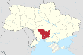
Mykolaiv Oblast (Ukrainian: Миколаївська область, Mykolajivśka oblasť; also referred to as Mykolaivshchyna, Ukrainian: Миколаївщина), also known as Nikolaev or Nikolayev Oblast (Russian: Николаевская область, Nikoláyevskaya óblasť), is an oblast (province) of Ukraine. The administrative center of the oblast is the city of Mykolaiv. Population: 1,108,394 (2021 est.)[4]
Geography[]
The Mykolaiv Oblast is located in the southern half of Ukraine. Its area (24,600 km²), comprises about 4.07% of the total area of Ukraine.
The Mykolaiv Oblast borders upon the Odessa Oblast in the west-southwest, the Kirovohrad Oblast in the north, the Dnipropetrovsk Oblast in the northeast, and the Kherson Oblast on the southeast.
To the south, the oblast is also bordered by the Black Sea. To Mykolaiv Oblast belong Kinburn Peninsula, Berezan Island in Black Sea, Pervomaisky Island in Dnieper Estuary.
In regards to relief, Mykolaiv Oblast is a plain that gently slopes in southern direction.[5] Bigger portion of the territory lays within Black Sea Lowland.[5] To the north there are spurs of Podolian and Dnieper uplands.[5] Among major valuable deposits and minerals there are nickel, uranium ores, granite, gneiss, quartzites.[5]
The climate is moderately continental with a mild winter of small snow amount and hot arid summer.[5]
In the territory of the region are eighty-five rivers that belong to basin of the Black Sea.[5] Among main rivers there are the Southern Bug (Boh), Inhulets, and Berezan.[5]
Points of interest[]
The following historic-cultural sites were nominated for the Seven Wonders of Ukraine or Seven Natural Wonders of Ukraine.
- Olbia, an ancient ruins of Greek colony near Ochakiv
- Black Sea Biosphere Reserve, located near Kinburn peninsula
- Granite-steppe lands of Buh, a landscape park located up north towards Podolia
- Inhul River Park, a landscape park in eastern part of the region
- Tylihul landscape park, on the administrative border with Odessa Oblast
- Dykyi Sad archaeological site (Wild Garden) in the city of Mykolaiv
Demographics[]
The current estimated population is 1.2 million people (as of 2005). The greater part of the oblast's population resides in urban type settlements (66%), with the remainder residing in agricultural areas. Also, almost 60% of the urban population resides in Mykolayiv, the industrial, cultural and administrative center of Mykolayiv Oblast.
The oblast's population density is one of the lowest in Ukraine – 52 people per 1 km². The oblast' is ranked 18 by the percentage of the population of Ukraine, that the Mykolaiv Oblast contain, which is 2.6%.
Age structure[]
- 0-14 years: 14.7%
 (male 88,668/female 83,434)
 - 15-64 years: 70.7%
 (male 396,342/female 432,808)
 - 65 years and over: 14.6%
 (male 56,527/female 114,987) (2013 official)
Median age[]
- total: 39.7 years
- male: 36.3 years
- female: 42.9 years (2013 official)
Ethnicity, language and citizenship[]
The oblast has a multi-ethnic composition; people of more than 100 ethnicities (national groups) live in the oblast.[6] The most common language in the oblast is Ukrainian; the second most common language is Russian.[7] In the city of Mykolaiv the most common language is Russian.[8]
At the time of the 2001 census, the oblast had 1,269,900 permanent residents.[9] Of these:
- 1,251,100 (99.1%) had Ukrainian citizenship.[9]
- 6,400 had citizenship of CIS countries.[9]
- 10,200 had citizenship of other countries.[9]
- 4,200 were without citizenship.[9]
- 1,000 who did not specify their citizenship.[9]
| Ethnicity ("Nationality") |
Permanent residents 2001 | Language at home 2001 [7] | Permanent residents 1989 | Language at home 1989 [7] | ||||
|---|---|---|---|---|---|---|---|---|
| Number [6] | % [6] | Ukrainian | Russian | % [6] | Ukrainian | Russian | ||
| All ethnicities [9] | 1,269,900 | 100.0% | 69.2% | 29.3% | 100.0% | 64.2% | 33.8% | |
| Ukrainian | 1,034,400 | 81.9% | 82.4% | 17.5% | 75.6% | |||
| Russian | 177,500 | 14.1% | 6.2% | 93.7% | 19.4% | |||
| Moldavian | 13,200 | 1.0% | 28.5% | 16.8% | 1.3% | |||
| Belarussian | 8,400 | 0.7% | 21.8% | 58.5% | 1.1% | |||
| Bulgarian | 5,600 | 0.4% | 16.9% | 53.2% | 0.5% | |||
| Armenian | 4,300 | 0.3% | 7.1% | 35.8% | 0.1% | |||
| Jew | 3,300 | 0.3% | 10.1% | 87.4% | 0.9% | |||
| Korean | 1,800 | 0.1% | 6.3% | 70.8% | 0.0% | |||
| Azerbaijanian | 1,500 | 0.1% | 8.1% | 33.3% | 0.1% | |||
| Gipsy (Roma) | 1,400 | 0.1% | 38.7% | 15.2% | 0.1% | |||
| Pole | 1,300 | 0.1% | 47.4% | 44.1% | 0.2% | |||
| Tatar | 1,300 | 0.1% | 7.3% | 73.5% | 0.1% | |||
| German | 1,200 | 0.1% | 26.8% | 67.7% | 0.1% | |||
| Other | 7,700 | 0.7% | 13.8% | 37.3% | 0.5% | |||
Administrative divisions[]
Mykolaiv Oblast formed in September 1937. It is subdivided into 19 raions (administrative districts), and 4 municipalities (misto) which are directly subordinate to the oblast government.
| Name | Ukrainian Name | Area (km2) |
Population census 2015[10] |
Admin.center | Urban Population Only |
|---|---|---|---|---|---|
| Mykolaiv | Миколаїв (місто) | 260 | 493,860 | Mykolaiv (city) | 493,860 |
| Pervomaisk | Первомайськ (місто) | 25 | 66,677 | Pervomaisk (city) | 66,677 |
| Voznesensk | Вознесенськ (місто) | 23 | 35,520 | Voznesensk (city) | 35,520 |
| Yuzhnoukrainsk | Южноукраїнськ (місто) | 24 | 40,353 | Yuzhnoukrainsk (city) | 40,353 |
| Arbuzynka Raion | Арбузинський (район) | 969 | 20,198 | Arbuzynka | 8,543 |
| Bashtanka Raion | Баштанський (район) | 1,706 | 37,721 | Bashtanka | 12,640 |
| Berezanka Raion | Березанський (район) | 1,378 | 23,409 | Berezanka | 4,120 |
| Bereznehuvate Raion | Березнегуватський (район) | 1,264 | 20,387 | Bereznehuvate | 7,742 |
| Bratske Raion | Братський (район) | 1,129 | 18,037 | Bratske | 5,325 |
| Domanivka Raion | Доманівський (район) | 1,458 | 25,500 | Domanivka | 6,137 |
| Kazanka Raion | Казанківський (район) | 1,349 | 19,745 | Kazanka | 7,207 |
| Kryve Ozero Raion | Кривоозерський (район) | 814 | 24,905 | Kryve Ozero | 7,823 |
| Mykolaiv Raion | Миколаївський (район) | 1,430 | 30,448 | Mykolaiv (city) | N/A * |
| Novyi Buh Raion | Новобузький (район) | 1,243 | 31,199 | Novyi Buh | 15,566 |
| Nova Odesa Raion | Новоодеський (район) | 1,428 | 33,602 | Nova Odesa | 12,108 |
| Ochakiv Raion | Очаківський (район) | 1,500 | 29,949 | Ochakiv | 14,489 |
| Pervomaisk Raion | Первомайський (район) | 1,319 | 30,275 | Pervomaisk (city) | N/A * |
| Snihurivka Raion | Снігурівський (район) | 1,350 | 40,420 | Snihurivka | 12,870 |
| Veselynove Raion | Веселинівський (район) | 1,245 | 23,161 | Veselynove | 8,060 |
| Vitovka Raion | Вітовській (район) | 1,460 | 50,565 | Mykolaiv (city) | N/A * |
| Voznesensk Raion | Вознесенський (район) | 1,392 | 30,562 | Voznesensk (city) | N/A * |
| Vradiivka Raion | Врадіївський (район) | 801 | 17,611 | Vradiivka | 8,391 |
| Yelanets Raion | Єланецький (район) | 1,018 | 15,530 | Yelanets | 4,912 |
| Total Oblast | Миколаївська (Область) | 24,585 | 1,159,634 | 791,227 |
Note: Asterisks (*) Though the administrative center of the rayon is housed in the city/town that it is named after, cities do not answer to the rayon authorities only towns do; instead they are directly subordinated to the oblast government and therefore are not counted as part of rayon statistics.
At a lower level of administration, these district-level administrations are subdivided into:
- Settlements — 922, including:
- Villages — 896;
- Cities/Towns — 21, including:
- Cities of raion subordinance — 4 (Bashtanka, Novyi Buh, Nova Odesa and Snihurivka);
- Urban-type settlement — 17;
- Selsovets — 287.
The local administration of the oblast is controlled by the Mykolaiv Oblast Rada. The governor of the oblast is the Mykolaiv Oblast Rada speaker, appointed by the President of Ukraine.
Infrastructure and economy[]
- Along the coast, there are several ports and the Mykolaiv International Airport.
- The region's railway network and infrastructure is part of the Odessa Railways.
- Through the region passes European route E58 and European route E95.
- The city of Mykolaiv is known for several of its shipyards that existed since the 19th century.
- South Ukraine Nuclear Power Plant
- Agrarian company Nibulon
- Mykolaiv Observatory
Public opinion[]
During the 1991 referendum, 89.45% of votes in Mykolaiv Oblast were in favor of the Declaration of Independence of Ukraine. A survey conducted in December 2014 by the Kiev International Institute of Sociology found 2.1% of the oblast's population supported their region joining Russia, 95.5% did not support the idea, and the rest were undecided or did not respond.[11]
See also[]
- Subdivisions of Ukraine
- Kherson Governorate
- Lysa Hora
- Romanization of Ukrainian
References[]
- ^ Syvak, Nina; Ponomarenko, Valerii; Khodzinska, Olha; Lakeichuk, Iryna (2011). Veklych, Lesia (ed.). Toponymic Guidelines for Map and Other Editors for International Use (PDF). United Nations Statistics Division. scientific consultant Iryna Rudenko; reviewed by Nataliia Kizilowa; translated by Olha Khodzinska. Kyiv: DerzhHeoKadastr and Kartographia. p. 20. ISBN 978-966-475-839-7. Retrieved 2020-10-06.
- ^ Zelensky appoints new head of Mykolaiv Regional State Administration, Ukrinform (26 November 2020)
- ^ Jump up to: a b https://news.pn/en/politics/149828
- ^ Jump up to: a b "Чисельність наявного населення України (Actual population of Ukraine)" (PDF) (in Ukrainian). State Statistics Service of Ukraine. Retrieved 11 July 2021.
- ^ Jump up to: a b c d e f g Vermenych, Ya. Mykolaiv Oblast (МИКОЛАЇВСЬКА ОБЛАСТЬ). Encyclopedia of History of Ukraine. 2009
- ^ Jump up to: a b c d National composition of population. About number and composition population of Mykolaiv Region by data All-Ukrainian census of the population 2001, State Statistics Committee of Ukraine, 2003–2004
- ^ Jump up to: a b c Linguistic composition of the population. About number and composition population of Mykolaiv Region by data All-Ukrainian census of the population 2001, State Statistics Committee of Ukraine, 2003–2004
- ^ In a survey in 2017, 63% of the population of the city of Mykolaiv spoke Russian at home, 7% Ukrainian, and 28% spoke both Ukrainian and Russian equally.
"Public Opinion Survey of Residents of Ukraine June 9 – July 7, 2017" (PDF). iri.org. August 2017. p. 89. Archived from the original (PDF) on 22 August 2017. - ^ Jump up to: a b c d e f g Permanent population. About number and composition population of Mykolaiv Region by data All-Ukrainian census of the population 2001, State Statistics Committee of Ukraine, 2003–2004
- ^ "Population Quantity". UkrStat (in Ukrainian). Retrieved 7 January 2016.
- ^ Лише 3% українців хочуть приєднання їх області до Росії [Only 3% of Ukrainians want their region to become part of Russia]. Dzerkalo Tyzhnia (in Ukrainian). 3 January 2015.
External links[]
- State Administration of Mykolaiv Oblast - official site (in Ukrainian, Russian, and English)
- Information Card of the Region - official site of the Cabinet of Ministers of Ukraine
| show Authority control |
|---|
- Mykolaiv Oblast
- Oblasts of Ukraine
- States and territories established in 1937
- 1937 establishments in Ukraine