Ostercappeln
Ostercappeln | |
|---|---|
 Saint Lambert Church | |
 Coat of arms | |
show Location of Ostercappeln within Osnabrück district | |
 Ostercappeln | |
| Coordinates: 52°21′N 08°14′E / 52.350°N 8.233°ECoordinates: 52°21′N 08°14′E / 52.350°N 8.233°E | |
| Country | Germany |
| State | Lower Saxony |
| District | Osnabrück |
| Subdivisions | 3 |
| Government | |
| • Mayor | Rainer Ellermann (CDU) |
| Area | |
| • Total | 100.18 km2 (38.68 sq mi) |
| Elevation | 73 m (240 ft) |
| Population (2020-12-31)[1] | |
| • Total | 9,773 |
| • Density | 98/km2 (250/sq mi) |
| Time zone | UTC+01:00 (CET) |
| • Summer (DST) | UTC+02:00 (CEST) |
| Postal codes | 49179 |
| Dialling codes | 05473 |
| Vehicle registration | OS |
| Website | www.ostercappeln.de |


Ostercappeln is a municipality in the district of Osnabrück, in Lower Saxony, Germany. It is situated in the Wiehengebirge, approx. 15 km northeast of Osnabrück. The municipality is made up of three villages, Ostercappeln, Venne and Schwagstorf, along the Bundesstraße 218. Ostercappeln is the location of the St. Raphael hospital, which serves a general hospital for the surrounding municipalities and as a center for pulmonary diseases for the district.
Mayor[]
Since 2001: Rainer Ellermann

Mill island in Venne
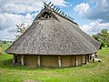
Replica of an Iron Age house in Darpvenne

Ludwig Windthorst Memorial
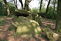
Megalithic chambered tomb "Darpvenner Steine I"

Megalithic chambered tomb "Darpvenner Steine II"

Megalithic chambered tomb "Darpvenner Steine III"

Megalithic chambered tomb "Driehauser Steine"

Megalithic chambered tomb "Dübberort I"

Megalithic chambered tomb "Dübberort II"


International relations[]
Ostercappeln is twinned with:
 Bolbec, France, since 1966
Sons and daughters of Ostercappeln[]

- Ludwig Windthorst (1812-1891), politician
- Michael Hohnstedt (born 1988), German footballer
- Timo Beermann (born 1990), German footballer
- Moritz Heyer (born 1995), German footballer
References[]
| show Towns and municipalities in Osnabrück (district) |
|---|
| show Authority control |
|---|
This Osnabrück district location article is a stub. You can help Wikipedia by . |
- Municipalities in Lower Saxony
- Osnabrück (district)
- Province of Hanover
- Weser-Ems region geography stubs