Oudehaske
This article may be expanded with text translated from the corresponding article in Western Frisian. (December 2008) Click [show] for important translation instructions.
|
Oudehaske
Aldehaske | |
|---|---|
Village | |
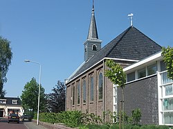 Oudehaske church | |
 Flag  Coat of arms | |
 Location in the former Skarsterlân municipality | |
 Oudehaske Location in the Netherlands | |
| Coordinates: Coordinates: 52°57′21″N 5°52′20″E / 52.95583°N 5.87222°E | |
| Country | |
| Province | |
| Municipality | |
| Population (2017) | |
| • Total | 1,980 |
| Time zone | UTC+1 (CET) |
| • Summer (DST) | UTC+2 (CEST) |
| Postal code | 8465 |
| Telephone area | 0513 |

Oudehaske (West Frisian: Aldehaske) is a village in De Fryske Marren in the province of Friesland, the Netherlands. It had a population of around 1980 in 2017.[1]
History[]
Before 2014, Oudehaske was part of the Skarsterlân municipality and before 1984 it was part of .
Oudehaske is known in traffic engineering circles for the radical innovation in street design pioneered there by Hans Monderman, removing signs and using subtle cues to indicate that the roadways are shared space between pedestrians and other vehicles.[1]
References[]
External links[]
![]() Media related to Oudehaske at Wikimedia Commons
Media related to Oudehaske at Wikimedia Commons
This Friesland location article is a stub. You can help Wikipedia by . |
Categories:
- De Fryske Marren
- Populated places in Friesland
- Friesland geography stubs