Pacetluky
Pacetluky | |
|---|---|
Municipality | |
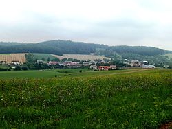 General view of the village | |
 Flag  Coat of arms | |
 Pacetluky | |
| Coordinates: 49°22′58″N 17°34′5″E / 49.38278°N 17.56806°ECoordinates: 49°22′58″N 17°34′5″E / 49.38278°N 17.56806°E | |
| Country | |
| Region | Zlín |
| District | Kroměříž |
| Area | |
| • Total | 2.55 km2 (0.98 sq mi) |
| Elevation | 277 m (909 ft) |
| Population (2006) | |
| • Total | 217 |
| • Density | 85/km2 (220/sq mi) |
| Postal code | 768 42 |
| Website | http://www.pacetluky.cz |

Pacetluky is a village and municipality (obec) in Kroměříž District in the Zlín Region of the Czech Republic.
The municipality covers an area of 2.55 square kilometres (0.98 sq mi), and has a population of 217 (as at 3 July 2006).
Pacetluky lies approximately 16 kilometres (10 mi) north-east of Kroměříž, 19 km (12 mi) north-west of Zlín, and 240 km (149 mi) east of Prague.
References[]
| Wikimedia Commons has media related to Pacetluky. |
| Authority control: National libraries |
|---|
This Zlín Region location article is a stub. You can help Wikipedia by . |
Categories:
- Villages in Kroměříž District
- Zlín Region geography stubs