Počenice-Tetětice
Počenice-Tetětice | |
|---|---|
Municipality | |
 | |
 Flag  Coat of arms | |
 Počenice-Tetětice | |
| Coordinates: 49°16′8″N 17°13′56″E / 49.26889°N 17.23222°ECoordinates: 49°16′8″N 17°13′56″E / 49.26889°N 17.23222°E | |
| Country | |
| Region | Zlín |
| District | Kroměříž |
| Area | |
| • Total | 8.53 km2 (3.29 sq mi) |
| Elevation | 268 m (879 ft) |
| Population (2006) | |
| • Total | 769 |
| • Density | 90/km2 (230/sq mi) |
| Postal code | 768 33 |
| Website | http://www.pocenice.cz |

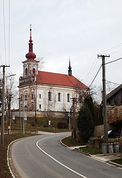
Počenice-Tetětice is a village and municipality (obec) in Kroměříž District in the Zlín Region of the Czech Republic.
The municipality covers an area of 8.53 square kilometres (3.29 sq mi), and has a population of 769 (as at 3 July 2006).
Počenice-Tetětice lies approximately 13 kilometres (8 mi) west of Kroměříž, 32 km (20 mi) west of Zlín, and 222 km (138 mi) south-east of Prague.
References[]
| Authority control: National libraries |
|---|
This Zlín Region location article is a stub. You can help Wikipedia by . |
Categories:
- Villages in Kroměříž District
- Zlín Region geography stubs