Pagsanjan Falls
| Pagsanjan Falls | |
|---|---|
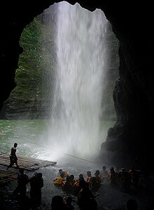 Inside the Devil's cave behind the waterfall | |
| Location | Cavinti, Laguna, Philippines |
| Coordinates | 14°15′45.32″N 121°29′59.86″E / 14.2625889°N 121.4999611°ECoordinates: 14°15′45.32″N 121°29′59.86″E / 14.2625889°N 121.4999611°E |
| Type | Plunge |
| Number of drops | 3 (one is hidden)[1] |
| Longest drop | 120 metres (390 ft) |
| Watercourse | Pagsanjan River |

Pagsanjan Falls, also known as Cavinti Falls (local name: Magdapio Falls) is one of the most famous waterfalls in the Philippines. Located in the province of Laguna, the falls is one of the major tourist attractions of the region. The three-drop waterfall is reached by a river trip on dugout canoe, known locally as Shooting the rapids, originating from the municipality of Pagsanjan.[2][3] The falls can also be reached from the top by a short hike from Cavinti.[1]
The boat ride has been an attraction since the Spanish Colonial Era with the oldest written account in 1894.[4] The town of Pagsanjan lies at the confluence of two rivers, the and the Bumbungan River (also known as the Pagsanjan River).[5]
Location[]
The main falls are actually located within the territorial jurisdiction of Cavinti, Laguna, approximately 3.2 Kilometers away from the boundaries of Cavinti and Pagsanjan, but the more popular access by canoes originates from the town of Pagsanjan. An ordinance was passed by the ruling body of the town of Cavinti was submitted to the Sangguniang Bayan (legislature of municipalities in the Philippines) on February 10, 2009 proposing the renaming of the falls to Cavinti Falls.[6]
National Park[]
The falls and gorge were declared as a National Park with Proc. 392 on March 29, 1939 and Proc. 1551 on March 31, 1976. The Pagsanjan Gorge National Park covers an area of 152.64 hectares (377.2 acres).[7][8]
Legend[]

According to history, the Pagsanjan Falls is rich in legendary lore. Long, long ago, recounts one legend, there were no falls. There were only the foliaged highlands, the twin rivers called Bumbungan and Balanac, and the alluvial delta where the town of Pagsanjan now nestles. On the eastern bank of the Bumbungan River lived two old brothers named Balubad and Magdapio. For many years, the two brothers enjoyed a rustic life of peace and happiness. But one day calamity struck. A terrible drought brought ruin and death; no rains came for successive months. The soil became dry as tinder. The blooming flowers and food plants withered and died. The birds, deer, wild hogs, monkeys, and other animals disappeared. The rivers, creeks, and mineral springs dried up. Not a single drop of life-giving rain fell from heaven.

Balubad and Magdapio suffered immensely. Day and night, they prayed for rain, but the gods did not heed their prayers. The older and weaker of the two brothers, Balubad, died of thirst. Magdapio, with a sorrowing heart, buried him on the slope of the mountain overlooking the river delta. This mountain is now called Balubad.
Left alone in a waterless world, Magdapio agonizingly trekked to the upper region of the arid riverbed. He reached the high rocky cliffs, after an arduous journey. But to his utter disappointment, he found no water.
"Ye gods!" he sobbed bitterly, "Where is the water?" In despair, he angrily hurled down his big cane among the rocks.
Suddenly, a spring bubbled on the spot where the cane fell. Rapidly it grew bigger. The fresh waters roared down the canyon walls, soon becoming a booming waterfall. Amazed at the miracle, Magdapio fell on his knees and thanked the gods. He drank the cool water until he felt new energy surging in his blood. Thus emerged the falls of Pagsanjan.[9]
Access to the falls[]
Pagsanjan[]
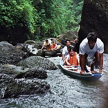
The most popular way of reaching the falls is through the Shooting the rapids boat ride, which originates from any of the resorts along Bumbungan and Balanac Rivers. Two skilled and licensed boatmen takes one to three passengers on wooden or fiberglass, long, narrow canoes to the falls, which could take more than an hour of paddling upstream depending on traffic and water level. The journey takes passengers through the narrow and verdant Pagsanjan Gorge lined with huge boulders, rocks and small waterfalls. The ride upstream ends in a natural pool below the falls where an optional raft ride takes visitors through a curtain of cascading water to the Devil's cave behind the falls. The return trip called Shooting the rapids is a thrill ride through fourteen rapids as the skilled boatmen maneuvers the boat through the narrow rocks as it head downstream.[10]
Cavinti[]
It is also possible to hike the falls from the town of Cavinti, Laguna. The municipal government of Cavinti established the Pueblo El Salvador Nature's Park and Picnic Grove, in Brgy. Tibatib on February 24, 2007 to capitalize in the popularity of Pagsanjan Falls, which is within the boundaries of the town.[11] A few small falls are located upriver by hiking from the park. The topmost stage of Pagsanjan falls, known as Nakulo Falls, can only be viewed from the view decks of the park. Only the top of the middle falls is visible from the park, the hidden second drop can only be viewed from the raft ride from below. To reach the main falls, one has to go down a steep steel ladder, which in one section goes vertically straight down. The raft to the falls and the 'shooting the rapid' boat ride are also available from the park management.[12]
See also[]
- List of waterfalls in the Philippines
- Pagsanjan Falls stamp error
References[]
- ^ Jump up to: a b mountains-and-beyond (2013-03). "Pagsanjan Falls via the Verticals of Cavinti". Mountains & Beyond. Retrieved on 2013-05-27.
- ^ Peters, Jens (2005). "Philippines Travel Guide, 2nd edition", p.255-256. Jens Peters Publications, Germany.
- ^ De Villa, Jill Gale (1988). "Philippine Vacations and Explorations", p.59. Devcon I.P. Inc., Manila.
- ^ Zaide, Gregorio F. (1975). "First Written Account of a trip to Pagsanjan Falls" Archived 2012-02-04 at the Wayback Machine. Pagsanjan.org. Retrieved on 2012-04-08.
- ^ "Pagsanjan Falls map". Flickr. Retrieved on 2012-04-08.
- ^ Lubugin, Frederick R. (2010-02-11). "Advocacy Campaign to rename Pagsanjan Falls to Cavinti Falls" Archived 2011-09-11 at the Wayback Machine. Cavinti Official Website. Retrieved on 2011-02-16.
- ^ "Establishing and Managing Protected Areas – List of Initial Components" Archived 2012-03-20 at the Wayback Machine. Protected Areas and Wildlife Bureaus. Retrieved on 2011-02-18.
- ^ Administration. "240 Protected Areas in the Philippines (2012)"[permanent dead link]. Protected Areas and Wildlife Bureau. Retrieved on 2012-06-11.
- ^ Zaide, Gregorio F. (1975). "Pagsanjan, in History and Legend, Chapter 3" Archived 2012-02-04 at the Wayback Machine. Pagsanjan.org. Retrieved on 2012-04-08.
- ^ "Shooting the rapids" Archived 2012-06-11 at the Wayback Machine. Pagsanjan.org. Retrieved on 2012-04-08.
- ^ (2007-12-13). "Magdapio Falls". Pinoy Mountaineer. Retrieved on 2013-05-27.
- ^ Besprend4Life (2012-03-24). "Pagsanjan Falls via vertical trek at Cavinti Laguna". Our WANDERful Journey. Retrieved on 2013-05-27.
External links[]
| Wikimedia Commons has media related to Pagsanjan Falls. |
| show Tourism in Calabarzon |
|---|
- Waterfalls of the Philippines
- Landforms of Laguna (province)
- Tourist attractions in Laguna (province)