Palmeira dos Índios
Palmeira dos Índios | |
|---|---|
Municipality | |
 | |
 Flag  Coat of arms | |
 Location of Palmeira dos Índios in the State of Alagoas | |
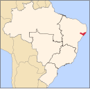
 Palmeira dos Índios Location in Brazil | |
| Coordinates: 9°24′25″S 36°37′40″W / 9.40694°S 36.62778°WCoordinates: 9°24′25″S 36°37′40″W / 9.40694°S 36.62778°W | |
| Country | |
| State | Alagoas |
| Mesoregion | |
| Microregion | |
| Founded | 1835 |
| Government | |
| • Mayor | Julio Cézar |
| Area | |
| • Total | 460.610 km2 (177.843 sq mi) |
| Elevation | 290 m (950 ft) |
| Population (2020.[1]) | |
| • Total | 73,337 |
| • Density | 160/km2 (410/sq mi) |
| Demonym(s) | Palmeirenses |
| Time zone | UTC−3 (BRT) |
| Website | Official website |
Palmeira dos Índios is a municipality located in the western of the Brazilian state of Alagoas. As of 2010, it has a population of around 70,000.
The city is situated in the interior of Alagoas. The Brazilian writer Graciliano Ramos was its mayor in 1927. It is the seat of the Roman Catholic Diocese of Palmeira dos Índios.
Languages[]
Xukuru-Kariri was spoken in Palmeira dos Índios.[2]
Climate[]
| hideClimate data for Palmeira dos Índios (1981–2010, extremes 1961–present) | |||||||||||||
|---|---|---|---|---|---|---|---|---|---|---|---|---|---|
| Month | Jan | Feb | Mar | Apr | May | Jun | Jul | Aug | Sep | Oct | Nov | Dec | Year |
| Record high °C (°F) | 38.9 (102.0) |
37.9 (100.2) |
37.4 (99.3) |
36.9 (98.4) |
36.4 (97.5) |
33.0 (91.4) |
30.8 (87.4) |
32.8 (91.0) |
35.3 (95.5) |
38.8 (101.8) |
37.8 (100.0) |
38.7 (101.7) |
38.9 (102.0) |
| Average high °C (°F) | 33.2 (91.8) |
33.2 (91.8) |
32.9 (91.2) |
31.1 (88.0) |
29.2 (84.6) |
27.0 (80.6) |
26.5 (79.7) |
26.8 (80.2) |
28.7 (83.7) |
31.3 (88.3) |
32.9 (91.2) |
33.4 (92.1) |
30.5 (86.9) |
| Daily mean °C (°F) | 26.4 (79.5) |
26.5 (79.7) |
26.6 (79.9) |
25.6 (78.1) |
24.3 (75.7) |
22.9 (73.2) |
22.1 (71.8) |
22.1 (71.8) |
23.0 (73.4) |
24.7 (76.5) |
25.9 (78.6) |
26.4 (79.5) |
24.7 (76.5) |
| Average low °C (°F) | 21.3 (70.3) |
21.5 (70.7) |
21.8 (71.2) |
21.2 (70.2) |
20.4 (68.7) |
19.6 (67.3) |
18.7 (65.7) |
18.5 (65.3) |
18.8 (65.8) |
19.9 (67.8) |
20.8 (69.4) |
21.3 (70.3) |
20.3 (68.5) |
| Record low °C (°F) | 15.1 (59.2) |
15.0 (59.0) |
15.6 (60.1) |
15.4 (59.7) |
14.7 (58.5) |
12.4 (54.3) |
14.8 (58.6) |
14.3 (57.7) |
10.8 (51.4) |
16.2 (61.2) |
14.6 (58.3) |
15.7 (60.3) |
10.8 (51.4) |
| Average precipitation mm (inches) | 38.5 (1.52) |
42.9 (1.69) |
68.2 (2.69) |
99.0 (3.90) |
131.0 (5.16) |
167.7 (6.60) |
134.2 (5.28) |
86.6 (3.41) |
41.8 (1.65) |
19.0 (0.75) |
15.9 (0.63) |
33.4 (1.31) |
878.2 (34.57) |
| Average precipitation days (≥ 1.0 mm) | 4 | 4 | 6 | 10 | 14 | 18 | 19 | 14 | 7 | 3 | 2 | 3 | 104 |
| Average relative humidity (%) | 66.9 | 67.3 | 69.6 | 76.3 | 80.8 | 84.9 | 84.7 | 82.8 | 77.1 | 70.8 | 66.3 | 65.8 | 74.4 |
| Mean monthly sunshine hours | 253.1 | 221.2 | 230.7 | 205.7 | 186.4 | 147.0 | 161.1 | 177.8 | 223.4 | 269.0 | 282.9 | 279.3 | 2,637.6 |
| Source 1: Instituto Nacional de Meteorologia[3] | |||||||||||||
| Source 2: Meteo Climat (record highs and lows)[4] | |||||||||||||
See also[]
References[]
- ^ IBGE 2020
- ^ Meader, Robert E. (1978). Indios do Nordeste: Levantamento sobre os remanescentes tribais do nordeste brasileiro (in Portuguese). Brasilia: SIL International.
- ^ "Normais Climatológicas Do Brasil 1981–2010" (in Portuguese). Instituto Nacional de Meteorologia. Retrieved 21 October 2018.
- ^ "Station Palmeira dos Indios" (in French). Meteo Climat. Retrieved 21 October 2018.
![]() Media related to Palmeira dos Índios at Wikimedia Commons
Media related to Palmeira dos Índios at Wikimedia Commons
Categories:
- Municipalities in Alagoas
- Alagoas geography stubs


