Piaçabuçu
Piaçabuçu | |
|---|---|
Municipality | |
| The Municipality of Piaçabuçu | |
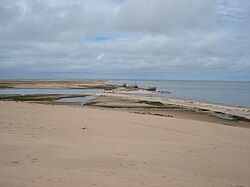 Base level of Rio São Francisco. | |
 Flag  Seal | |
| Nickname(s): PBU | |
| Coordinates: 10°24′21″S 36°26′02″W / 10.40583°S 36.43389°WCoordinates: 10°24′21″S 36°26′02″W / 10.40583°S 36.43389°W | |
| Country | |
| Region | Northeast |
| State | |
| Founded | May 31, 1832 |
| Government | |
| • Mayor | Dalmo Moreira Santana Júnior (PSB) |
| Area | |
| • Total | 242.9 km2 (93.8 sq mi) |
| Elevation | 5 m (16 ft) |
| Population (2020) | |
| • Total | 17,848 |
| • Density | 82.0/km2 (212/sq mi) |
| [1] | |
| Time zone | UTC−3 (BRT) |
| HDI (2000) | 0.613 – medium[2] |
Piaçabuçu is a municipality located in the Brazilian state of Alagoas. It is the southernmost municipality in Alagoas, and lies near both São Francisco River and the Atlantic Ocean. Its population was 17,848 (2020) and its area is 240 km².[3]
References[]
Capital: Maceió | ||
| Arapiraca | 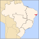 | |
| Palmeira dos Índios | ||
| Traipu | ||
| Litoral Norte Alagoano | ||
| Maceió | ||
| Mata Alagoana | ||
| Penedo | ||
| São Miguel dos Campos | ||
| Serrana dos Quilombos | ||
| Alagoana do Sertão do São Francisco | ||
| Batalha | ||
| Santana do Ipanema | ||
| Serrana do Sertão Alagoano | ||
This Alagoas, Brazil location article is a stub. You can help Wikipedia by . |
Categories:
- Populated places established in 1832
- Populated coastal places in Alagoas
- Municipalities in Alagoas
- 1832 establishments in Brazil
- Alagoas geography stubs