Palmyra, Wisconsin
Palmyra, Wisconsin | |
|---|---|
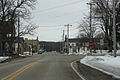
 Looking east at downtown Palmyra | |
 Location of Palmyra in Jefferson County, Wisconsin. | |
| Coordinates: 42°52′46″N 88°35′54″W / 42.87944°N 88.59833°WCoordinates: 42°52′46″N 88°35′54″W / 42.87944°N 88.59833°W | |
| Country | |
| State | |
| County | Jefferson |
| Government | |
| • Type | Village Board (President - Trustees) |
| • President | Kathy Weiss |
| Area | |
| • Total | 2.21 sq mi (5.71 km2) |
| • Land | 2.15 sq mi (5.58 km2) |
| • Water | 0.05 sq mi (0.13 km2) |
| Elevation | 850 ft (259 m) |
| Population | |
| • Total | 1,781 |
| • Estimate (2019)[5] | 1,757 |
| • Density | 815.31/sq mi (314.86/km2) |
| Time zone | UTC-6 (Central (CST)) |
| • Summer (DST) | UTC-5 (CDT) |
| Area code(s) | 262 |
| FIPS code | 55-61050[4] |
| GNIS feature ID | 1571003[3] |
| Website | www |

Palmyra is a village in Jefferson County, Wisconsin, United States, along the Scuppernong River. It was named after the desert oasis city of Palmyra, Syria, due to its dry, sandy soil.[6] The population was 1,781 at the 2010 census.[7] The village is adjacent to the Town of Palmyra.
History[]
The Town of Palmyra was established in 1846. In 1876, part of the Town of Palmyra was incorporated as the village of Palmyra.[8][9]
Palmyra was known for its mineral springs. The was established in 1870, situated on what is known today as Lower Spring Lake. The sanitarium was a substantially built four-story brick structure containing spacious halls, wide verandas, and modern health and wellness accessories. The building contained facilities for the administration of various forms of electro-shock massage.[6] The rooms were spacious and luxuriously furnished, providing a variety of salt, shower, shampoo, natural mineral, Turkish, and Russian style baths. There was a large gymnasium, theater, music hall, billiard parlors, bowling alleys, archery and tennis courts. The surrounding forty-acre forest of native oaks was referred to as the Sanitarium Grove - today part of the Southern Kettle Moraine State Forest - which contained winding pedestrian paths and resting nooks. The sanitarium was one and half miles from a large spring known by name as the Aurelian Spring, the Great Geyser Spring, or the Big Blue Spring. It was 50 feet across, 38 feet deep, with a flow of clear crystal-blue water that was believed to have therapeutic remedial value.[6][10] A dam and spillway was later built downstream of the Great Geyer Spring, forming what is today known as Blue Spring Lake. In 1924, the sanitarium became the Druggist's National Home, a home for aged and infirm druggists, but a few years later, interest in the therapeutic mineral treatments declined and the facility was closed. In the late 1950s, the building was raised and the land leveled.[11]
Geography[]
Palmyra is located at 42°52′37″N 88°35′13″W / 42.87694°N 88.58694°W (42.87721, -88.587117).[12]
According to the United States Census Bureau, the village has a total area of 1.25 square miles (3.24 km2), of which 1.20 square miles (3.11 km2) is land and 0.05 square miles (0.13 km2) is water.[13]
Demographics[]
As of 2000 the median income for a household in the village was $45,521, and the median income for a family was $50,192. Males had a median income of $37,150 versus $24,950 for females. The per capita income for the village was $19,849. About 3.4% of families and 5.4% of the population were below the poverty line, including 6.0% of those under age 18 and 4.7% of those age 65 or over.
| Historical population | |||
|---|---|---|---|
| Census | Pop. | %± | |
| 1870 | 703 | — | |
| 1880 | 598 | −14.9% | |
| 1890 | 567 | −5.2% | |
| 1900 | 716 | 26.3% | |
| 1910 | 649 | −9.4% | |
| 1920 | 685 | 5.5% | |
| 1930 | 642 | −6.3% | |
| 1940 | 711 | 10.7% | |
| 1950 | 862 | 21.2% | |
| 1960 | 1,000 | 16.0% | |
| 1970 | 1,341 | 34.1% | |
| 1980 | 1,515 | 13.0% | |
| 1990 | 1,540 | 1.7% | |
| 2000 | 1,766 | 14.7% | |
| 2010 | 1,781 | 0.8% | |
| 2019 (est.) | 1,757 | [5] | −1.3% |
| U.S. Decennial Census[14] | |||
2010 census[]
As of the census[2] of 2010, there were 1,781 people, 704 households, and 469 families residing in the village. The population density was 1,484.2 inhabitants per square mile (573.1/km2). There were 769 housing units at an average density of 640.8 per square mile (247.4/km2). The racial makeup of the village was 94.7% White, 0.6% African American, 0.5% Native American, 0.2% Asian, 3.2% from other races, and 0.8% from two or more races. Hispanic or Latino of any race were 10.3% of the population.
There were 704 households, of which 35.1% had children under the age of 18 living with them, 51.0% were married couples living together, 10.4% had a female householder with no husband present, 5.3% had a male householder with no wife present, and 33.4% were non-families. 26.3% of all households were made up of individuals, and 10.9% had someone living alone who was 65 years of age or older. The average household size was 2.53 and the average family size was 3.04.
The median age in the village was 37.2 years. 25.4% of residents were under the age of 18; 8.7% were between the ages of 18 and 24; 26.9% were from 25 to 44; 26% were from 45 to 64; and 12.9% were 65 years of age or older. The gender makeup of the village was 49.9% male and 50.1% female.
Notable people[]
- Hiram J. Ball, farmer and Wisconsin state legislator[15]
- Justin Beaver, college football player for the University of Wisconsin-Whitewater
- Adoniram J. Holmes, congressman from Iowa
- Knute Nelson, U.S. senator from Minnesota
- Iva Bigelow Weaver, soprano and music educator based in Milwaukee
- Frederick L. Wieseman, U.S. Marine Lieutenant general
- Susan Hawk, Survivor, Season One, Borneo [16]
Images[]
Looking south on Wisconsin Highway 59

Looking west at downtown Palmyra

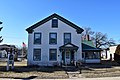
Former police station
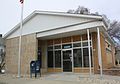
Post office

Sign on WIS 59

Welcome sign
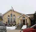
Powers Memorial Library in Palmyra

Lions Park


References[]
- ^ "2019 U.S. Gazetteer Files". United States Census Bureau. Retrieved August 7, 2020.
- ^ Jump up to: a b "U.S. Census website". United States Census Bureau. Retrieved 2012-11-18.
- ^ Jump up to: a b "US Board on Geographic Names". United States Geological Survey. 2007-10-25. Retrieved 2008-01-31.
- ^ "U.S. Census website". United States Census Bureau. Retrieved 2008-01-31.
- ^ Jump up to: a b "Population and Housing Unit Estimates". United States Census Bureau. May 24, 2020. Retrieved May 27, 2020.
- ^ Jump up to: a b c Crook, James King (1899). The Mineral Waters of the United States and Their Therapeutic Uses: With an Account of the Various Mineral Spring Localities, Their Advantages as Health Resorts, Means of Access, Etc., to which is Added an Appendix on Potable Waters. Lea Brothers & Company. p. 539.
Palmyra Springs Sanitarium and Mineral Springs.
- ^ "Profile of General Population and Housing Characteristics: 2010 Demographic Profile Data (DP-1): Palmyra village, Wisconsin". United States Census Bureau. Retrieved October 5, 2012.
- ^ The Town of Palmyra
- ^ The Village of Palmyra
- ^ "Palmyra Historical Society 1990 Newsletter" (PDF).
- ^ "Palmyra Springs Sanatorium - Asylum Projects". www.asylumprojects.org. Retrieved 2018-09-23.
- ^ "US Gazetteer files: 2010, 2000, and 1990". United States Census Bureau. 2011-02-12. Retrieved 2011-04-23.
- ^ "US Gazetteer files 2010". United States Census Bureau. Archived from the original on 2012-01-24. Retrieved 2012-11-18.
- ^ "Census of Population and Housing". Census.gov. Retrieved June 4, 2015.
- ^ 'Wisconsin Blue Book 1878,' Biographical Sketch of Hiram J. Ball, pg. 472-473
- ^ "Susan - Survivor Cast Member".
External links[]
| Wikimedia Commons has media related to Palmyra, Wisconsin. |
- Village of Palmyra official website
- Palmyra Area Chamber of Commerce
- Sanborn fire insurance maps: 1892 1898 1904 1919
| show Municipalities and communities of Jefferson County, Wisconsin, United States |
|---|

| show Authority control |
|---|
- Villages in Jefferson County, Wisconsin
- Villages in Wisconsin