Pantelleria
Pantelleria | |
|---|---|
| Comune di Pantelleria | |
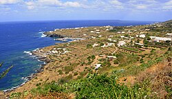 Panorama of Pantelleria | |
 Coat of arms | |
show Location of Pantelleria | |
 Pantelleria Location of Pantelleria in Sicily | |
| Coordinates: 36°47′15″N 11°59′33″E / 36.78750°N 11.99250°ECoordinates: 36°47′15″N 11°59′33″E / 36.78750°N 11.99250°E | |
| Country | Italy |
| Region | Sicily |
| Province | Trapani (TP) |
| Government | |
| • Mayor | Vincenzo Vittorio Campo |
| Area | |
| • Total | 83 km2 (32 sq mi) |
| Elevation | 836 m (2,743 ft) |
| Population (31 December 2017)[2] | |
| • Total | 7,759 |
| • Density | 93/km2 (240/sq mi) |
| Demonym(s) | Panteschi |
| Time zone | UTC+1 (CET) |
| • Summer (DST) | UTC+2 (CEST) |
| Postal code | 91017 |
| Dialing code | 0923 |
| Patron saint | St. Fortunatus |
| Website | Official website |


Pantelleria (Italian pronunciation: [pantelleˈriːa];[3]), the ancient Cossyra or Cossura, is an Italian island and comune in the Strait of Sicily in the Mediterranean Sea, 100 km (62 mi) southwest of Sicily and 60 km (37 mi) east of the Tunisian coast. On clear days Tunisia is visible from the island. Administratively Pantelleria's comune belongs to the Sicilian province of Trapani.
Description[]
With an area of 83 km2 (32 sq mi), Pantelleria is the largest volcanic satellite island of Sicily. The last eruption occurred below sea level in 1891, and today phenomena related to volcanic activity can be observed, such as hot springs and fumaroles. The highest peak, the Montagna Grande, reaches 836 m (2,743 ft) above sea level. The islanders speak Pantesco, a dialect of Sicilian influenced by Arabic.
Names[]

The Carthaginians knew the island as YRNM (Punic: