Papakōwhai
Papakōwhai | |
|---|---|
Suburb of Porirua City Council | |
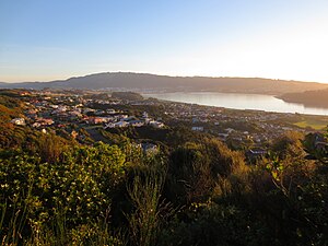 A view from the north-east: Porirua Harbour to the right, Porirua city centre and Rangituhi/Colonial Knob ridge in the background | |
 | |
| Country | New Zealand |
| City | Porirua City Council |
| Electoral ward | Northern Ward/Pukerua ki te Raki[1] |
| Area | |
| • Land | 143 ha (353 acres) |
| Population (June 2020)[2] | |
| • Total | 2,340 |
| Postcode(s) | 5024 |
| (Porirua Harbour) | Paremata[3] | |
|
|
Ascot Park | |
| Aotea |

Papakōwhai is a suburb of Porirua City. It lies approximately 22 kilometres (14 mi) north of Wellington in New Zealand.
The name "Papakōwhai" (Māori pronunciation: [papaˈkɔfai]) in the Māori language means "yellow earth". As well as being the name of the suburb it is the name of the main road connecting the suburb to the south. Most of the other streets in Papakōwhai take their names from Scottish rivers.[4][5][6]
The first European known to have settled in the area was William Bowler in the early 19th century.
As of 2016 Papakōwhai includes the Royal New Zealand Police College and Aotea Lagoon public park.
Demographics[]
Papakōwhai statistical area covers 1.43 km2 (0.55 sq mi).[7] It had an estimated population of 2,340 as of June 2020, with a population density of 1,636.36 people per km2.
| Year | Pop. | ±% p.a. |
|---|---|---|
| 2006 | 2,304 | — |
| 2013 | 2,280 | −0.15% |
| 2018 | 2,268 | −0.11% |
| Source: [8] | ||
Papakōwhai had a population of 2,268 at the 2018 New Zealand census, a decrease of 12 people (-0.5%) since the 2013 census, and a decrease of 36 people (-1.6%) since the 2006 census. There were 759 households. There were 1,086 males and 1,185 females, giving a sex ratio of 0.92 males per female. The median age was 42.9 years (compared with 37.4 years nationally), with 411 people (18.1%) aged under 15 years, 393 (17.3%) aged 15 to 29, 1,077 (47.5%) aged 30 to 64, and 390 (17.2%) aged 65 or older.
Ethnicities were 83.6% European/Pākehā, 13.6% Māori, 6.9% Pacific peoples, 8.7% Asian, and 1.5% other ethnicities (totals add to more than 100% since people could identify with multiple ethnicities).
The proportion of people born overseas was 21.6%, compared with 27.1% nationally.
Although some people objected to giving their religion, 49.2% had no religion, 39.2% were Christian, 1.7% were Hindu, 1.2% were Muslim, 0.4% were Buddhist and 2.0% had other religions.
Of those at least 15 years old, 531 (28.6%) people had a bachelor or higher degree, and 210 (11.3%) people had no formal qualifications. The median income was $43,400, compared with $31,800 nationally. The employment status of those at least 15 was that 1,026 (55.3%) people were employed full-time, 282 (15.2%) were part-time, and 57 (3.1%) were unemployed.[8]
Education[]
Papakowhai School is a co-educational state primary school for Year 1 to 8 students,[9][10] with a roll of 521 as of March 2021.[11]
References[]
- ^ Porirua City Council, Porirua City Boundary, Suburban Areas and Wards Map
- ^ "Population estimate tables - NZ.Stat". Statistics New Zealand. Retrieved 22 October 2019.
- ^ Porirua City Council, Porirua City Boundary and Suburban Areas Map
- ^ Porirua City Council. "Porirua City Boundary and Suburban Areas Map". Porirua City Council. Archived from the original on 29 May 2013. Retrieved 14 May 2013.
- ^ Statistics New Zealand (2006). "QuickStats About Papakowhai". Statistics New Zealand. Retrieved 14 May 2013.
- ^ Porirua City Council. "Porirua City Boundary, Suburban Areas and Wards Map". Porirua City Council.
- ^ "ArcGIS Web Application". statsnz.maps.arcgis.com. Retrieved 30 May 2021.
- ^ Jump up to: a b "Statistical area 1 dataset for 2018 Census". Statistics New Zealand. March 2020. Papakōwhai (240000). 2018 Census place summary: Papakōwhai
- ^ "Papakowhai School Official School Website". papakowhai.school.nz.
- ^ "Papakowhai School Education Review Office Report". ero.govt.nz. Education Review Office.
- ^ "Papakowhai School Ministry of Education School Profile". educationcounts.govt.nz. Ministry of Education.
External links[]

- Suburbs of Porirua