Pukerua Bay
hideThis article has multiple issues. Please help or discuss these issues on the talk page. (Learn how and when to remove these template messages)
|
Pukerua Bay | |
|---|---|
Suburb of Porirua | |
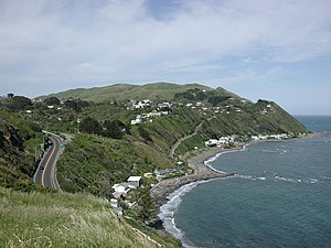 Pukerua Bay, looking west. | |
 | |
| Country | New Zealand |
| City | Porirua |
| Electoral ward | Northern Ward/Pukerua ki te Raki |
| Area | |
| • Land | 817 ha (2,019 acres) |
| Population (June 2020)[1] | |
| • Total | 2,030 |
| Train station(s) | Pukerua Bay Railway Station (Muri Railway Station closed in 2011) |
| Tasman Sea | Kapiti Island | Paekākāriki |
| Cook Strait |
|
Paekākāriki Hill |
| Plimmerton |
Pukerua Bay is a small seaside community at the southern end of the Kapiti Coast, New Zealand. In local government terms it is the northernmost suburb of Porirua City. It is 12 km north of the Porirua City Centre on State Highway 1 (SH1), and 30 km north of central Wellington. In Māori, the words puke rua literally mean two hills but it is not clear to which hills the name refers.[2]
Geography[]

The majority of Pukerua Bay is situated in a saddle between hills, about 60-90m above sea level, offering sea views (and views of Kapiti Island and occasionally Mounts Taranaki and Ruapehu to the north) from many houses. The Kaikoura range on the South Island including Mt Tapuaenuku can be seen from some places at the southern end of the township. The coast around Pukerua Bay is fairly steep, with only a few houses nestled in a row behind the two sandy beach areas. The surrounding hills are mainly farm land used for sheep and cattle grazing, providing a rural backdrop to the east and west. The area to the south, along SH1, turns into Taupo Swamp towards Plimmerton.
Pukerua Bay's main residential areas are along Rawhiti Road, west of SH1, the central clifftop, Sea Vista Drive east of SH1 and the beach frontage extending east (Brendan Beach) and west of Beach Road. There is a pedestrian bridge over SH1 near Wairaka Road's Kindergarten and pre-school and the school's back entrance (the main entrance is on Rawhiti Road).
There are two walks between Pukerua Bay and Plimmerton (5 km south), one around the rocky coast, and one inland (part of a longer cycleway) parallel to the railway. The inland route is pre-European – it was traditionally known as te taua tapu (the sacred war-party). The cycleway is known as Te Ara Harakeke (the flax road).[3] The coastal route goes past Marble Arch (Te Ana Puta) to Wairaka Rock on an uninhabited part of Pukerua Bay, the only, mainland home of Whitaker's Skink (Cyclodina whitakeri), an icon of the bay. According to legend, the rock is the petrified wife of culture hero Haunui-a-Nanaia, who pursued her from Māhia Peninsula, naming places on the way including Manawatu, Ohau and Turakina.
The waters around Pukerua Bay, from a point north halfway to Paekakariki to Wairaka Point south of Pukerua Bay, are currently protected by a rāhui.[citation needed]
History[]
The earliest people known to have lived in the area around Pukerua Bay were the Ngati Iri Māori tribe and later the Muaupoko, who built Waimapihi Pā near today's seaward end of Rawhiti Road. Pukerua Bay was on the main road for Māori travellers going north or south. About 1822, it was invaded from Kapiti Island by Te Rauparaha and his Ngati Toa people. According to oral tradition, the Muaupoko people fled up the gorge of the Waimapihi stream (on the Ohariu Fault line), abandoning their treasures on the way.
The land blocks originally surveyed (Wairaka in the west, Waimapihi and Pukerua in the east) were sold to settlers from Europe for farming in the late 19th century. Charles Gray was the first resident to subdivide and sell residential sections in Pukerua Bay, in the early 20th century.
Pukerua Bay's development history is curious because the railway went through it (1886) for years before there was good road access (1940), so it grew at first on the waterfront as a weekend destination. The original railway station was named "Pukerua" until it was changed briefly to Waimapihi in the 1920s and then to "Pukerua Bay" to avoid confusion with "Pukerau" in the South Island.
By the end of the 1920s, Pukerua Bay numbered 100 houses, a small school on land donated by Charles Gray, and a few small stores. Electricity was put through from Plimmerton to Pukerua Bay in 1927 and in 1928 the track between Plimmerton and Pukerua Bay was formed into a narrow road. The beach remained the main attraction for weekend visitors from Wellington (by steam train) as there was still no highway and no bridge at Paremata.
Most of the clifftop development dates from after World War II and Pukerua Bay has its own branch of the Returned Services Association. Pukerua Bay experienced significant growth in the 1950s and 1960s, being connected to Wellington via the (by then double-tracked) railway line and accessible from north and south via SH1. In 1973, Pukerua Bay joined Porirua City Council to get the issues of water and sewerage connection addressed.
Growth continued in the 1970s with the Sea Vista Drive subdivision and soon the fact that SH1, with increasing traffic, was going through the middle of Pukerua Bay became an issue. In 1989, an over-bridge over SH1 was opened, after continued lobbying by local residents, which included continually walking across the pedestrian crossing to hold up traffic.
Demographics[]
Pukerua Bay statistical area covers 8.17 km2 (3.15 sq mi).[4] It had an estimated population of 2,030 as of June 2020, with a population density of 248.47 people per km2.
| Year | Pop. | ±% p.a. |
|---|---|---|
| 2006 | 1,725 | — |
| 2013 | 1,896 | +1.36% |
| 2018 | 1,962 | +0.69% |
| Source: [5] | ||
Pukerua Bay had a population of 1,962 at the 2018 New Zealand census, an increase of 66 people (3.5%) since the 2013 census, and an increase of 237 people (13.7%) since the 2006 census. There were 705 households. There were 963 males and 999 females, giving a sex ratio of 0.96 males per female. The median age was 40.6 years (compared with 37.4 years nationally), with 426 people (21.7%) aged under 15 years, 303 (15.4%) aged 15 to 29, 996 (50.8%) aged 30 to 64, and 234 (11.9%) aged 65 or older.
Ethnicities were 91.9% European/Pākehā, 14.1% Māori, 3.7% Pacific peoples, 2.3% Asian, and 2.4% other ethnicities (totals add to more than 100% since people could identify with multiple ethnicities).
The proportion of people born overseas was 22.9%, compared with 27.1% nationally.
Although some people objected to giving their religion, 60.1% had no religion, 29.4% were Christian, 0.5% were Buddhist and 3.2% had other religions.
Of those at least 15 years old, 537 (35.0%) people had a bachelor or higher degree, and 138 (9.0%) people had no formal qualifications. The median income was $44,800, compared with $31,800 nationally. The employment status of those at least 15 was that 891 (58.0%) people were employed full-time, 255 (16.6%) were part-time, and 48 (3.1%) were unemployed.[5]
Features[]

Pukerua Bay has a branch of Porirua Library, a Returned Servicemen's Association, tennis club, scout hall, sports field, and several nature reserves and trails. Retail facilities include a convenience store, hairdresser and second-hand bookstore. There is one railway station, Pukerua Bay Railway Station, on the North Island Main Trunk railway, with suburban services provided by Metlink. The train journey to Wellington takes about 35 minutes, to Paraparaumu 20 minutes. A second station, Muri Railway Station, 1.2 km by road north of Pukerua Bay station, was closed on 30 April 2011.[6]
Pukerua Bay's skatepark was rebuilt in 2009 in a collaborative venture between the Porirua City Council, the Residents Association, and PKBSK8 Inc. Funding was also provided by the Caversham Foundation and the Mana Community Grants Foundation. The park is adjacent to the Pukerua Bay railway station, and replaces an old asphalt bowl which the City Council claims was the only purpose-built skatepark in the Southern Hemisphere when it opened in 1976.
A popular 10-kilometre walkway, the Escarpment Track, constructed as part of the national Te Araroa Trail, links Pukerua Bay with Paekakariki. The walk features views to Kapiti Island.
Education[]
Pukerua Bay School is a co-educational state primary school for Year 1 to 8 students,[7][8] with a roll of 191 as of March 2021.[9]
Pukerua Bay has a kindergarten and a pre-school.
Notable residents[]
Former residents include poets Louis Johnston, Sam Hunt, James K. Baxter, Denis Glover, Meg Campbell, Alistair Campbell, film editor John Gilbert, and actress Davina Whitehouse. Pukerua Bay is also the birthplace and childhood home of film director Peter Jackson, whose first feature film, Bad Taste, was filmed there. He later went on the direct the successful Lord of the Rings films and Hobbit Trilogy.[10]
Prominent current residents are author Gay Hay, actor Christopher Winchester, former CEO of Meridian Energy Dr Keith Turner, artist Pauline Morse and composer Jenny McLeod.
Notes[]
- ^ "Population estimate tables - NZ.Stat". Statistics New Zealand. Retrieved 22 October 2019.
- ^ "1000 Māori place names". New Zealand Ministry for Culture and Heritage. 6 August 2019.
- ^ "Ara Harakeke:Te Araroa - New Zealand's Trail - Wellington". www.teararoa.org.nz. Retrieved 21 December 2019.
- ^ "ArcGIS Web Application". statsnz.maps.arcgis.com. Retrieved 23 May 2021.
- ^ Jump up to: a b "Statistical area 1 dataset for 2018 Census". Statistics New Zealand. March 2020. Pukerua Bay (238800). 2018 Census place summary: Pukerua Bay
- ^ "Pukerua Bay skate park rebuild". Porirua City Council. Archived from the original on 9 February 2013. Retrieved 10 March 2009.
- ^ "Pukerua Bay School Official School Website". pukeruabay.school.nz.
- ^ "Pukerua Bay School Education Review Office Report". ero.govt.nz. Education Review Office.
- ^ "Pukerua Bay School Ministry of Education School Profile". educationcounts.govt.nz. Ministry of Education.
- ^ "Suburb spotlight: Pukerua Bay". Stuff.
External links[]
| Wikimedia Commons has media related to Pukerua Bay. |

- Populated places in the Wellington Region
- Suburbs of Porirua