Pauline, Kansas
Pauline, Kansas | |
|---|---|
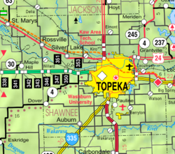
 Pauline (2005) | |
 | |
 Pauline | |
| Coordinates: 38°57′48″N 95°41′26″W / 38.96333°N 95.69056°WCoordinates: 38°57′48″N 95°41′26″W / 38.96333°N 95.69056°W[1] | |
| Country | United States |
| State | Kansas |
| County | Shawnee |
| Elevation | 1,027 ft (313 m) |
| Time zone | UTC-6 (CST) |
| • Summer (DST) | UTC-5 (CDT) |
| Area code | 785 |
| FIPS code | 20-54750 [1] |
| GNIS ID | 479073 [1] |


Pauline is an unincorporated community in Shawnee County, Kansas, United States.[1] Located south of Topeka, it lies next to Forbes Field on southwest Topeka Boulevard. It is occasionally seen as part of the South City Industry Park for Topeka with its many large businesses.
History[]
The first post office in Pauline was established in 1872.[2]
There are about 30 houses along with about 20 mobile homes in the mobile home park. Businesses there include three restaurants, two gas stations, an auction house, a bar, a laundromat, and a grocery store. Pauline also has a Super 8 Motel and a modern campground with hook-ups.
See also[]
- Old Prairie Town at Ward-Meade Historic Site
- Topeka metropolitan area
References[]
- ^ a b c d e Geographic Names Information System (GNIS) details for Pauline, Kansas; United States Geological Survey (USGS); October 13, 1978.
- ^ "Kansas Post Offices, 1828-1961". Kansas Historical Society. Archived from the original on October 9, 2013. Retrieved 27 June 2014.
Further reading[]
External links[]
Municipalities and communities of Shawnee County, Kansas, United States | ||
|---|---|---|
| Cities |  | |
| Unincorporated communities | ||
| Ghost town | ||
| Townships | ||
| Footnotes | †This populated place is designated a Census-Designated Place (CDP) by the United States Census Bureau. ‡This populated place also has portions in an adjacent county or counties. | |
| ||
Categories:
- Unincorporated communities in Kansas
- Unincorporated communities in Shawnee County, Kansas
- Topeka metropolitan area, Kansas
- Kansas geography stubs