Wakarusa, Kansas
Wakarusa, Kansas | |
|---|---|
 | |
 Wakarusa | |
| Coordinates: 38°53′09″N 95°41′45″W / 38.88583°N 95.69583°WCoordinates: 38°53′09″N 95°41′45″W / 38.88583°N 95.69583°W[1] | |
| Country | United States |
| State | Kansas |
| County | Shawnee |
| Area | |
| • Total | 4.999 sq mi (12.95 km2) |
| • Land | 4.965 sq mi (12.86 km2) |
| • Water | 0.034 sq mi (0.09 km2) |
| Elevation | 951 ft (290 m) |
| Population | |
| • Total | 260 |
| • Density | 52/sq mi (20/km2) |
| Time zone | UTC-6 (CST) |
| • Summer (DST) | UTC-5 (CDT) |
| ZIP code | 66546 |
| Area code | 785 |
| FIPS code | 20-74425 [1] |
| GNIS ID | 479077 [1] |


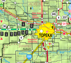
Wakarusa is an unincorporated community in Shawnee County, Kansas, United States.[1] Wakarusa is 11 miles (18 km) south of downtown Topeka. Wakarusa has a post office with ZIP code 66546.[4] As of the 2010 census, its population was 260.[3] Wakarusa is also the name of an unincorporated community in adjacent Douglas County, Kansas, 6.6 mi (10.6 km) southwest of downtown Lawrence and the name of the township that includes Lawrence, Kansas.
History[]
Wakarusa was founded in 1858.[5]
Demographics[]
For statistical purposes, the United States Census Bureau has defined Wakarusa as a census-designated place (CDP).
Education[]
The community is served by Auburn–Washburn USD 437 public school district.
References[]
- ^ a b c d e Geographic Names Information System (GNIS) details for Wakarusa, Kansas; United States Geological Survey (USGS); October 13, 1978.
- ^ "US Gazetteer files: 2010, 2000, and 1990". United States Census Bureau. 2011-02-12. Retrieved 2011-04-23.
- ^ a b "U.S. Census website". United States Census Bureau. Retrieved 2011-05-14.
- ^ ZIP Code Lookup
- ^ Blackmar, Frank Wilson (1912). Kansas: A Cyclopedia of State History, Volume 2. Standard Publishing Company. pp. 854.
Further reading[]
- Living in the Depot: The Two-Story Railroad Station; H. Roger Grant; University of Iowa Press; 130 pages; 1993; ISBN 978-0877455882. Contains historic images of Kansas stations at Alta Vista, Bucklin, Comiskey, Haddam, Hoyt, and Wakarusa.
External links[]
Municipalities and communities of Shawnee County, Kansas, United States | ||
|---|---|---|
| Cities |  | |
| Unincorporated communities | ||
| Ghost town | ||
| Townships | ||
| Footnotes | †This populated place is designated a Census-Designated Place (CDP) by the United States Census Bureau. ‡This populated place also has portions in an adjacent county or counties. | |
| ||
Categories:
- Census-designated places in Shawnee County, Kansas
- Census-designated places in Kansas