Pemberton, New Jersey
Pemberton, New Jersey | |
|---|---|
| Borough of Pemberton | |
 Center of the borough | |
 Pemberton Borough highlighted in Burlington County. Inset map: Burlington County highlighted in the State of New Jersey. | |
 Census Bureau map of Pemberton, New Jersey | |
 Pemberton Location in Burlington County | |
| Coordinates: 39°58′20″N 74°41′12″W / 39.97219°N 74.686558°WCoordinates: 39°58′20″N 74°41′12″W / 39.97219°N 74.686558°W[1][2] | |
| Country | |
| State | |
| County | |
| Incorporated | December 15, 1826 |
| Government | |
| • Type | Borough |
| • Body | Borough Council |
| • Mayor | Harold Griffin (R, term ends December 31, 2023)[3] |
| • Administrator / Municipal clerk | Donna J. Mull[4] |
| Area | |
| • Total | 0.61 sq mi (1.57 km2) |
| • Land | 0.59 sq mi (1.53 km2) |
| • Water | 0.02 sq mi (0.04 km2) 2.79% |
| Area rank | 540th of 565 in state 39th of 40 in county[1] |
| Elevation | 36 ft (11 m) |
| Population | |
| • Total | 1,409 |
| • Estimate (2019)[10] | 1,324 |
| • Rank | 518th of 566 in state 37th of 40 in county[11] |
| • Density | 2,408.7/sq mi (930.0/km2) |
| • Density rank | 255th of 566 in state 13th of 40 in county[11] |
| Time zone | UTC−05:00 (Eastern (EST)) |
| �� Summer (DST) | UTC−04:00 (Eastern (EDT)) |
| ZIP Code | |
| Area code(s) | 609 exchanges: 726, 894[14] |
| FIPS code | 3400557480[1][15][16] |
| GNIS feature ID | 0885346[1][17] |
| Website | www |


Pemberton is a borough in Burlington County, New Jersey, United States. As of the 2010 United States Census, the borough's population was 1,409.[7][8][9] reflecting an increase of 199 (+16.4%) from the 1,210 counted in the 2000 Census, which had in turn declined by 157 (-11.5%) from the 1,367 counted in the 1990 Census.[18]
Pemberton was incorporated as a borough by an act of the New Jersey Legislature on December 15, 1826, within portions of New Hanover Township and Northampton Township (now known as Mount Holly Township). Pemberton became an independent borough c. 1894.[19] The borough is named for James Pemberton, a property owner in the area.[20]
It is a dry community, where alcohol cannot be sold, as affirmed by a referendum in 1980.[21][22]
Geography[]
According to the United States Census Bureau, the borough had a total area of 0.61 square miles (1.57 km2), including 0.59 square miles (1.53 km2) of land and 0.02 square miles (0.04 km2) of water (2.79%).[1][2]
Pemberton is an independent municipality within the boundaries of and completely surrounded by Pemberton Township,[23][24][25] making it one of 21 pairs of "doughnut towns" in the state, where one municipality entirely surrounds another.[26]
Demographics[]
| Historical population | |||
|---|---|---|---|
| Census | Pop. | %± | |
| 1870 | 797 | — | |
| 1880 | 799 | 0.3% | |
| 1890 | 834 | 4.4% | |
| 1900 | 771 | −7.6% | |
| 1910 | 797 | 3.4% | |
| 1920 | 800 | 0.4% | |
| 1930 | 783 | −2.1% | |
| 1940 | 906 | 15.7% | |
| 1950 | 1,194 | 31.8% | |
| 1960 | 1,250 | 4.7% | |
| 1970 | 1,344 | 7.5% | |
| 1980 | 1,198 | −10.9% | |
| 1990 | 1,367 | 14.1% | |
| 2000 | 1,210 | −11.5% | |
| 2010 | 1,409 | 16.4% | |
| 2019 (est.) | 1,324 | [10][27] | −6.0% |
| Population sources: 1870-2000[28] 1870-1920[29] 1870[30][31] 1880-1890[32] 1890-1910[33] 1910-1930[34] 1930-1990[35] 2000[36][37] 2010[7][8][9] | |||
Census 2010[]
The 2010 United States census counted 1,409 people, 581 households, and 404 families in the borough. The population density was 2,408.7 per square mile (930.0/km2). There were 642 housing units at an average density of 1,097.5 per square mile (423.7/km2). The racial makeup was 74.38% (1,048) White, 15.26% (215) Black or African American, 0.21% (3) Native American, 3.26% (46) Asian, 0.00% (0) Pacific Islander, 3.12% (44) from other races, and 3.76% (53) from two or more races. Hispanic or Latino of any race were 12.70% (179) of the population.[7]
Of the 581 households, 25.1% had children under the age of 18; 51.3% were married couples living together; 13.1% had a female householder with no husband present and 30.5% were non-families. Of all households, 24.1% were made up of individuals and 6.9% had someone living alone who was 65 years of age or older. The average household size was 2.42 and the average family size was 2.79.[7]
19.0% of the population were under the age of 18, 8.9% from 18 to 24, 25.2% from 25 to 44, 33.6% from 45 to 64, and 13.3% who were 65 years of age or older. The median age was 43.1 years. For every 100 females, the population had 90.7 males. For every 100 females ages 18 and older there were 90.5 males.[7]
The Census Bureau's 2006-2010 American Community Survey showed that (in 2010 inflation-adjusted dollars) median household income was $65,568 (with a margin of error of +/- $9,899) and the median family income was $74,773 (+/- $17,679). Males had a median income of $44,750 (+/- $5,830) versus $46,406 (+/- $8,202) for females. The per capita income for the borough was $36,399 (+/- $6,078). About 2.8% of families and 6.0% of the population were below the poverty line, including 12.5% of those under age 18 and 1.8% of those age 65 or over.[38]
Census 2000[]
As of the 2000 United States Census[15] there were 1,210 people, 470 households, and 316 families residing in the borough. The population density was 2,034.5 people per square mile (791.8/km2). There were 513 housing units at an average density of 862.6 per square mile (335.7/km2). The racial makeup of the borough was 78.43% White, 12.73% African American, 0.66% Native American, 2.40% Asian, 2.73% from other races, and 3.06% from two or more races. Hispanic or Latino of any race were 8.60% of the population.[36][37]
There were 470 households, out of which 35.7% had children under the age of 18 living with them, 44.7% were married couples living together, 15.1% had a female householder with no husband present, and 32.6% were non-families. 26.4% of all households were made up of individuals, and 6.0% had someone living alone who was 65 years of age or older. The average household size was 2.56 and the average family size was 3.06.[36][37]
In the borough the population was spread out, with 26.8% under the age of 18, 9.5% from 18 to 24, 34.7% from 25 to 44, 20.1% from 45 to 64, and 8.9% who were 65 years of age or older. The median age was 34 years. For every 100 females, there were 103.0 males. For every 100 females age 18 and over, there were 95.6 males.[36][37]
The median income for a household in the borough was $44,063, and the median income for a family was $48,500. Males had a median income of $34,911 versus $25,474 for females. The per capita income for the borough was $18,909. About 7.2% of families and 7.8% of the population were below the poverty line, including 9.4% of those under age 18 and 1.0% of those age 65 or over.[36][37]
Government[]
Local government[]
Pemberton Borough is governed under the Borough form of New Jersey municipal government, which is used in 218 municipalities (of the 565) statewide, making it the most common form of government in New Jersey.[39] The governing body is comprised of a Mayor and a Borough Council, with all positions elected at-large on a partisan basis as part of the November general election. A Mayor is elected directly by the voters to a four-year term of office. The Borough Council is comprised of six members elected to serve three-year terms on a staggered basis, with two seats coming up for election each year in a three-year cycle.[5] The Borough form of government used by Pemberton is a "weak mayor / strong council" government in which council members act as the legislative body with the mayor presiding at meetings and voting only in the event of a tie. The mayor can veto ordinances subject to an override by a two-thirds majority vote of the council. The mayor makes committee and liaison assignments for council members, and most appointments are made by the mayor with the advice and consent of the council.[40][41]
As of 2020, the Mayor of Pemberton Borough is Republican Harold Griffin, whose term of office ends December 31, 2023. Members of the Borough Council are Council President Bonnie Haines (R, 2022), Robert Brock (R, 2022), Steven Fenster (D, 2021), Terry Jerome (R, 2020), Tim Quinlan (R, 2020) and Cliff Rutherford (D, 2021).[42][43][44][45][46]
The borough council appointed Harold Griffin in January 2014 to fill the vacant seat of William Kochersperger, who had resigned from his seat as mayor that month.[47]
Federal, state and county representation[]
Pemberton Borough is located in the 3rd Congressional District[48] and is part of New Jersey's 8th state legislative district.[8][49][50]
For the 117th United States Congress, New Jersey's 3rd Congressional District is represented by Andy Kim (D, Bordentown).[51] New Jersey is represented in the United States Senate by Democrats Cory Booker (Newark, term ends 2027)[52] and Bob Menendez (Harrison, term ends 2025).[53][54]
For the 2018–2019 session (Senate, General Assembly), the 8th Legislative District of the New Jersey Legislature is represented in the State Senate by Dawn Marie Addiego (D, Evesham Township) and in the General Assembly by Joe Howarth (R, Evesham Township) and Ryan Peters (R, Hainesport Township).[55][56]
Burlington County is governed by a board of chosen freeholders, whose five members are elected at-large in partisan elections to three-year terms of office on a staggered basis, with either one or two seats coming up for election each year; at an annual reorganization meeting, the board selects a director and deputy director from among its members.[57] As of 2018, Burlington County Board of Chosen Freeholders are Director Kate Gibbs (R, Lumberton Township, term as freeholder and as director ends December 31, 2018),[58] Deputy Director Linda Hughes (R, Evesham Township, term as freeholder and as deputy director ends 2018)[59] Tom Pullion (D, Edgewater Park, 2020),[60] Balvir Singh (D, Burlington Township, 2020),[61] and Latham Tiver (R, Southampton Township, 2019).[62][57][63][64] Burlington County's Constitutional Officers are County Clerk Tim Tyler (R, Fieldsboro, 2018),[65][66] Sheriff Jean E. Stanfield (R, Westampton, 2019)[67][68] and Surrogate Mary Ann O'Brien (R, Medford, 2021).[69][70][64]
Politics[]
As of March 23, 2011, there were a total of 883 registered voters in Pemberton, of which 250 (28.3% vs. 33.3% countywide) were registered as Democrats, 266 (30.1% vs. 23.9%) were registered as Republicans and 367 (41.6% vs. 42.8%) were registered as Unaffiliated. There were no voters registered to other parties.[71] Among the borough's 2010 Census population, 62.7% (vs. 61.7% in Burlington County) were registered to vote, including 77.4% of those ages 18 and over (vs. 80.3% countywide).[71][72]
In the 2012 presidential election, Democrat Barack Obama received 346 votes (52.9% vs. 58.1% countywide), ahead of Republican Mitt Romney with 294 votes (45.0% vs. 40.2%) and other candidates with 4 votes (0.6% vs. 1.0%), among the 654 ballots cast by the borough's 901 registered voters, for a turnout of 72.6% (vs. 74.5% in Burlington County).[73][74] In the 2008 presidential election, Democrat Barack Obama received 383 votes (55.4% vs. 58.4% countywide), ahead of Republican John McCain with 295 votes (42.7% vs. 39.9%) and other candidates with 9 votes (1.3% vs. 1.0%), among the 691 ballots cast by the borough's 882 registered voters, for a turnout of 78.3% (vs. 80.0% in Burlington County).[75] In the 2004 presidential election, Republican George W. Bush received 259 votes (56.9% vs. 46.0% countywide), ahead of Democrat John Kerry with 193 votes (42.4% vs. 52.9%) and other candidates with 3 votes (0.7% vs. 0.8%), among the 455 ballots cast by the borough's 591 registered voters, for a turnout of 77.0% (vs. 78.8% in the whole county).[76]
In the 2013 gubernatorial election, Republican Chris Christie received 320 votes (69.1% vs. 61.4% countywide), ahead of Democrat Barbara Buono with 129 votes (27.9% vs. 35.8%) and other candidates with 5 votes (1.1% vs. 1.2%), among the 463 ballots cast by the borough's 902 registered voters, yielding a 51.3% turnout (vs. 44.5% in the county).[77][78] In the 2009 gubernatorial election, Republican Chris Christie received 229 votes (48.4% vs. 47.7% countywide), ahead of Democrat Jon Corzine with 185 votes (39.1% vs. 44.5%), Independent Chris Daggett with 38 votes (8.0% vs. 4.8%) and other candidates with 5 votes (1.1% vs. 1.2%), among the 473 ballots cast by the borough's 897 registered voters, yielding a 52.7% turnout (vs. 44.9% in the county).[79]
Historic district[]
Pemberton Historic District | |
U.S. National Register of Historic Places | |
U.S. Historic district | |
 Houses on Hanover Street | |
| Location | Portions of Budd Avenue; Early Alley; Jarvis, Hanover, Hough, Egbert, Davis, Mary, Antis, Elizabeth, Early, Pemberton, Jane, Reeves, Reynolds, and St. John streets |
|---|---|
| Area | 94 acres (38 ha) |
| Architectural style | Classical Revival, Late Victorian, Federal |
| NRHP reference No. | 88000688[80] |
| NJRHP No. | 858[81] |
| Significant dates | |
| Added to NRHP | March 22, 1989 |
| Designated NJRHP | October 7, 1987 |
The Pemberton Historic District is a 94-acre (38 ha) historic district encompassing the borough. It was added to the National Register of Historic Places on March 22, 1989, for its significance in historic archaeology, architecture, industry, religion and exploration/settlement. The district has 180 contributing buildings, including the individually listed Morris Mansion and Mill.[82]
The First Baptist Church was organized in 1752.[83] The current church on Hanover Street was built in 1861 with Greek Revival style.[82] The Methodist Church was founded in 1774, the third in the state. The current church was built in 1895.[82]
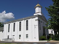
First Baptist Church

United Methodist Church
Education[]
The Pemberton Borough School District is no longer operational.[84] Starting with the 2007–08 school year, all public school students from Pemberton Borough attend the schools of the Pemberton Township School District, with Pemberton Borough a part of the combined school district.[85][86] The district is one of 31 former Abbott districts statewide,[87] which are now referred to as "SDA Districts" based on the requirement for the state to cover all costs for school building and renovation projects in these districts under the supervision of the New Jersey Schools Development Authority.[88][89] The school district serves Pemberton Borough and Pemberton Township (including the communities of Browns Mills, Country Lake Estates, Pemberton Heights and Presidential Lakes Estates and the Pemberton Township portion of Fort Dix).[90][86] As of the 2018–19 school year, the district, comprised of 11 schools, had an enrollment of 4,880 students and 434.0 classroom teachers (on an FTE basis), for a student–teacher ratio of 11.2:1.[91]
Schools in the district (with 2018–19 enrollment data from the National Center for Education Statistics[92]) are Pemberton Early Childhood Education Center[93] (with 465 students; in PreK), Samuel T. Busansky Elementary School[94] (333; 3-5), Isaiah Haines Elementary School[95] (291; K-2), Alexander Denbo Elementary School[96] (309; 3-5), Howard L. Emmons Elementary School[97] (288; K-2), Fort Dix Elementary School[98] (451; PreK-5), Harker-Wylie Elementary School[99] (284; K-2), Joseph S. Stackhouse Elementary School[100] (283; 3-5), Marcus Newcomb Middle School[101] (373; 6), Helen A. Fort Middle School[102] (664; 7-8) and Pemberton Township High School[103] (989; 9-12).[104][105]
Students from Pemberton, and from all of Burlington County, are eligible to attend the Burlington County Institute of Technology, a countywide public school district that serves the vocational and technical education needs of students at the high school and post-secondary level at its campuses in Medford and Westampton Township.[106]
Transportation[]

Roads and highways[]
As of May 2010, the borough had a total of 8.81 miles (14.18 km) of roadways, of which 4.99 miles (8.03 km) were maintained by the municipality and 3.82 miles (6.15 km) by Burlington County.[107]
No Interstate, U.S. or state highways directly serve Pemberton. The most significant roadway passing through the borough is County Route 530.
Public transportation[]
NJ Transit provides bus service in the township on the 317 route between Asbury Park and Philadelphia.[108][109] BurLink bus service is offered on the B1 route between Beverly and Pemberton).[110]
Notable people[]
People who were born in, residents of, or otherwise closely associated with Pemberton include:
- Jeff Celentano (born 1960), actor, screenwriter and director.[111]
- George Franklin Fort (1808–1872), 16th Governor of New Jersey.[112]
- John Franklin Fort (1852–1920), 33rd Governor of New Jersey, from 1908–1911.[113]
- Bushrod W. Lott (1826-1886), politician in the Minnesota Territory who served as United States Consul in Tehuantepec, Mexico, from 1862 to 1865, appointed by President Abraham Lincoln.[114]
- Rex Marshall (1919-1983), actor, television announcer and radio personality.[115]
- Isaac Witkin (1936-2006), sculptor.[116]
References[]
- ^ Jump up to: a b c d e f 2019 Census Gazetteer Files: New Jersey Places, United States Census Bureau. Accessed July 1, 2020.
- ^ Jump up to: a b US Gazetteer files: 2010, 2000, and 1990, United States Census Bureau. Accessed September 4, 2014.
- ^ 2020 New Jersey Mayors Directory, New Jersey Department of Community Affairs. Accessed February 1, 2020. As of date accessed, the source incorrectly lists David Patriarca, mayor of Pemberton Township.
- ^ Municipal Clerk, Borough of Pemberton. Accessed April 1, 2020.
- ^ Jump up to: a b 2012 New Jersey Legislative District Data Book, Rutgers University Edward J. Bloustein School of Planning and Public Policy, March 2013, p. 43.
- ^ U.S. Geological Survey Geographic Names Information System: Borough of Pemberton, Geographic Names Information System. Accessed March 8, 2013.
- ^ Jump up to: a b c d e f DP-1 - Profile of General Population and Housing Characteristics: 2010 for Pemberton borough, Burlington County, New Jersey, United States Census Bureau. Accessed August 30, 2012.
- ^ Jump up to: a b c d Municipalities Sorted by 2011-2020 Legislative District, New Jersey Department of State. Accessed February 1, 2020.
- ^ Jump up to: a b c Profile of General Demographic Characteristics: 2010 for Pemberton borough, New Jersey Department of Labor and Workforce Development. Accessed August 30, 2012.
- ^ Jump up to: a b Annual Estimates of the Resident Population for Minor Civil Divisions in New Jersey: April 1, 2010 to July 1, 2019, United States Census Bureau. Accessed May 21, 2020.
- ^ Jump up to: a b GCT-PH1 Population, Housing Units, Area, and Density: 2010 - State -- County Subdivision from the 2010 Census Summary File 1 for New Jersey, United States Census Bureau. Accessed August 7, 2013.
- ^ Look Up a ZIP Code for Pemberton, NJ, United States Postal Service. Accessed August 30, 2012.
- ^ Zip Codes, State of New Jersey. Accessed August 29, 2013.
- ^ Area Code Lookup - NPA NXX for Pemberton, NJ, Area-Codes.com. Accessed August 29, 2013.
- ^ Jump up to: a b U.S. Census website, United States Census Bureau. Accessed September 4, 2014.
- ^ Geographic codes for New Jersey, Missouri Census Data Center. Accessed September 1, 2019.
- ^ US Board on Geographic Names, United States Geological Survey. Accessed September 4, 2014.
- ^ Table 7. Population for the Counties and Municipalities in New Jersey: 1990, 2000 and 2010 Archived August 7, 2017, at the Wayback Machine, New Jersey Department of Labor and Workforce Development, February 2011. Accessed August 30, 2012.
- ^ Snyder, John P. The Story of New Jersey's Civil Boundaries: 1606-1968, Bureau of Geology and Topography; Trenton, New Jersey; 1969. p. 98. Accessed August 30, 2012.
- ^ Hutchinson, Viola L. The Origin of New Jersey Place Names, New Jersey Public Library Commission, May 1945. Accessed September 16, 2015.
- ^ New Jersey Division of Alcoholic Beverage Control. New Jersey ABC list of dry towns (May 1, 2013)
- ^ Giordano, Rita. "More towns catching liquor-license buzz; Moorestown considers ending its dry spell", The Philadelphia Inquirer, June 24, 2007. Accessed February 16, 2014.
- ^ Areas touching Pemberton, MapIt. Accessed April 1, 2020.
- ^ Municipalities within Burlington County, NJ, Delaware Valley Regional Planning Commission. Accessed April 1, 2020.
- ^ New Jersey Municipal Boundaries, New Jersey Department of Transportation. Accessed November 15, 2019.
- ^ DeMarco, Megan. "Voters to decide whether to merge two Princetons into one", The Star-Ledger, November 3, 2011. Accessed January 8, 2017. "There are 22 sets of 'doughnut towns' in New Jersey, those where one town wraps around the other town". Note that following voter approval of the Princeton merger, 21 pairs of "doughnut towns" remain.
- ^ Census Estimates for New Jersey April 1, 2010 to July 1, 2019, United States Census Bureau. Accessed May 21, 2020.
- ^ Barnett, Bob. Population Data for Burlington County Municipalities, 1800 - 2000, WestJersey.org, January 6, 2011. Accessed August 30, 2012.
- ^ Compendium of censuses 1726-1905: together with the tabulated returns of 1905, New Jersey Department of State, 1906. Accessed August 7, 2013.
- ^ Raum, John O. The History of New Jersey: From Its Earliest Settlement to the Present Time, Volume 1, p. 265, J. E. Potter and company, 1877. Accessed August 7, 2013. "The thriving village of Pemberton is in this township and contained a population in 1870 of 797; the celebrated Brown's Mills are also here."
- ^ Staff. A compendium of the ninth census, 1870, p. 259. United States Census Bureau, 1872. Accessed August 7, 2013.
- ^ Porter, Robert Percival. Preliminary Results as Contained in the Eleventh Census Bulletins: Volume III - 51 to 75, p. 97. United States Census Bureau, 1890. Accessed August 30, 2012.
- ^ Thirteenth Census of the United States, 1910: Population by Counties and Minor Civil Divisions, 1910, 1900, 1890, United States Census Bureau, p. 335. Accessed August 30, 2012.
- ^ Fifteenth Census of the United States : 1930 - Population Volume I, United States Census Bureau, p. 714. Accessed August 30, 2012.
- ^ Table 6. New Jersey Resident Population by Municipality: 1930 - 1990, New Jersey Department of Labor and Workforce Development. Accessed August 9, 2016.
- ^ Jump up to: a b c d e Census 2000 Profiles of Demographic / Social / Economic / Housing Characteristics for Pemberton borough, New Jersey Archived 2015-02-01 at the Wayback Machine, United States Census Bureau. Accessed August 30, 2012.
- ^ Jump up to: a b c d e DP-1: Profile of General Demographic Characteristics: 2000 - Census 2000 Summary File 1 (SF 1) 100-Percent Data for Pemberton borough, Burlington County, New Jersey Archived 2020-02-12 at archive.today, United States Census Bureau. Accessed August 30, 2012.
- ^ DP03: Selected Economic Characteristics from the 2006-2010 American Community Survey 5-Year Estimates for Pemberton borough, Burlington County, New Jersey Archived 2020-02-12 at archive.today, United States Census Bureau. Accessed June 21, 2012.
- ^ Inventory of Municipal Forms of Government in New Jersey, Rutgers University Center for Government Studies, July 1, 2011. Accessed November 18, 2019.
- ^ Cerra, Michael F. "Forms of Government: Everything You've Always Wanted to Know, But Were Afraid to Ask" Archived 2014-09-24 at the Wayback Machine, New Jersey State League of Municipalities. Accessed November 30, 2014.
- ^ "Forms of Municipal Government in New Jersey", p. 6. Rutgers University Center for Government Studies. Accessed June 3, 2015.
- ^ 2020 Mayor and Council, Borough of Pemberton. Accessed April 1, 2020. As of date accessed, Griffin is listed with an incorrect term-end year of 2022.
- ^ 2019 Municipal User Friendly Budget, Borough of Pemberton. Accessed October 23, 2019.
- ^ November 5, 2019 General Election Summary Report Official Results, Burlington County, New Jersey, updated November 16, 2019. Accessed January 1, 2020.
- ^ November 6, 2018 General Election Summary Report Official Results, Burlington County, New Jersey, updated November 17, 2018. Accessed January 1, 2019.
- ^ November 7, 2017 General Election Summary Report Official Results, Burlington County, New Jersey, updated November 16, 2017. Accessed January 1, 2018.
- ^ Hart, Steven. "New mayor appointed by Pemberton Borough Council", Burlington County Times, January 29, 2014. Accessed December 28, 2014. "Harold Griffin, a retired high school guidance counselor and former borough tax collector, is now the town's mayor.Griffin, 80, was appointed Monday by a unanimous vote of the Borough Council. He succeeds William Kochersperger, who resigned earlier this month over health concerns."
- ^ Plan Components Report, New Jersey Redistricting Commission, December 23, 2011. Accessed February 1, 2020.
- ^ 2019 New Jersey Citizen's Guide to Government, New Jersey League of Women Voters. Accessed October 30, 2019.
- ^ Districts by Number for 2011-2020, New Jersey Legislature. Accessed January 6, 2013.
- ^ Directory of Representatives: New Jersey, United States House of Representatives. Accessed January 3, 2019.
- ^ [1], United States Senate. Accessed April 30, 2021. "He now owns a home and lives in Newark's Central Ward community."
- ^ Biography of Bob Menendez, United States Senate, January 26, 2015. "Menendez, who started his political career in Union City, moved in September from Paramus to one of Harrison's new apartment buildings near the town's PATH station.."
- ^ [2]. United States Senate. Accessed April 30, 2021. "Booker, Cory A. - (D - NJ) Class II; Menendez, Robert - (D - NJ) Class I"
- ^ Legislative Roster 2018-2019 Session, New Jersey Legislature. Accessed January 22, 2018.
- ^ District 8 Legislators, New Jersey Legislature. Accessed January 22, 2018.
- ^ Jump up to: a b Board of Chosen Freeholders, Burlington County, New Jersey. Accessed June 6, 2018.
- ^ Kate Gibbs, Burlington County, New Jersey. Accessed June 6, 2018.
- ^ Linda Hughes, Burlington County, New Jersey. Accessed June 6, 2018.
- ^ Tom Pullion, Burlington County, New Jersey. Accessed June 6, 2018.
- ^ Balvir Singh, Burlington County, New Jersey. Accessed June 6, 2018.
- ^ Latham Tiver, Burlington County, New Jersey. Accessed June 6, 2018.
- ^ 2018 County Data Sheet, Burlington County, New Jersey. Accessed June 6, 2018.
- ^ Jump up to: a b A Guide to Burlington County: 2015, Burlington County, New Jersey. Accessed October 22, 2017.
- ^ County Clerk, Burlington County. Accessed July 19, 2017.
- ^ Members List: Clerks, Constitutional Officers Association of New Jersey. Accessed October 22, 2017.
- ^ Sheriff's Department, Burlington County. Accessed July 19, 2017.
- ^ Members List: Sheriffs, Constitutional Officers Association of New Jersey. Accessed October 22, 2017.
- ^ Surrogate, Burlington County. Accessed July 19, 2017.
- ^ Members List: Surrogates, Constitutional Officers Association of New Jersey. Accessed October 22, 2017.
- ^ Jump up to: a b Voter Registration Summary - Burlington, New Jersey Department of State Division of Elections, March 23, 2011. Accessed December 28, 2014.
- ^ GCT-P7: Selected Age Groups: 2010 - State -- County Subdivision; 2010 Census Summary File 1 for New Jersey Archived 2020-02-12 at archive.today, United States Census Bureau. Accessed December 28, 2014.
- ^ Presidential November 6, 2012 General Election Results - Burlington County Archived December 26, 2014, at the Wayback Machine, New Jersey Department of State Division of Elections, March 15, 2013. Accessed December 28, 2014.
- ^ Number of Registered Voters and Ballots Cast November 6, 2012 General Election Results - Burlington County Archived December 26, 2014, at the Wayback Machine, New Jersey Department of State Division of Elections, March 15, 2013. Accessed December 28, 2014.
- ^ 2008 Presidential General Election Results: Burlington County, New Jersey Department of State Division of Elections, December 23, 2008. Accessed December 28, 2014.
- ^ 2004 Presidential Election: Burlington County, New Jersey Department of State Division of Elections, December 13, 2004. Accessed December 28, 2014.
- ^ 2013 Governor: Burlington County, New Jersey Department of State Division of Elections, January 29, 2014. Accessed December 28, 2014.
- ^ Number of Registered Voters and Ballots Cast November 5, 2013 General Election Results : Burlington County, New Jersey Department of State Division of Elections, January 29, 2014. Accessed December 28, 2014.
- ^ 2009 Governor: Burlington County Archived 2016-01-13 at the Wayback Machine, New Jersey Department of State Division of Elections, December 31, 2009. Accessed December 28, 2014.
- ^ "National Register Information System – (#88000688)". National Register of Historic Places. National Park Service. November 2, 2013.
- ^ "New Jersey and National Registers of Historic Places - Burlington County" (PDF). New Jersey Department of Environmental Protection - Historic Preservation Office. March 23, 2021. p. 14.
- ^ Jump up to: a b c McDermott, Vincent J. (December 1984). "National Register of Historic Places Inventory/Nomination: Pemberton Historic District". National Park Service. With accompanying 19 photos
- ^ Greenagel, Frank L. "First Baptist Church of Pemberton". The New Jersey Churchscape. Rutgers University Press. ISBN 9-780-8135-2990-5.
- ^ Levinsky, David. "Pemberton Borough moving forward with school demolition", Burlington County Times, February 5, 2020. Accessed April 1, 2020. "The school opened in 1960 but has been boarded up and empty since 2007 when the kindergarten-through-sixth grade elementary school was closed in favor of sending all students from the borough to schools in neighboring Pemberton Township. Originally the borough paid the township a lump sum tuition based on the number of students who attended, but the non-operating school district was merged into the Pemberton Township School District in 2008."
- ^ Pemberton Township Board of Education District Policy 0110 - Identification, Pemberton Township School District. Accessed May 13, 2020. "Purpose: The Board of Education exists for the purpose of providing a thorough and efficient system of free public education in grades Pre-Kindergarten through twelve in the Pemberton Township School District. Composition: The Pemberton Township School District is comprised of all the area within the municipal boundaries of Pemberton Township and Pemberton Borough."
- ^ Jump up to: a b District Overview, Pemberton Township School District. Accessed May 13, 2020. "Pemberton Township Schools serves approximately 5,000 students from Pemberton Township, Pemberton Borough and Joint Base McGuire-Dix-Lakehurst. With a dedicated early childhood education center serving 3 and 4 year-old pre-kindergarten students, seven elementary schools (grades kindergarten through 5th), two middle schools (one for grade 6, another for grades 7 and 8), and high school (grades 9-12), Pemberton Township Schools provide a quality, comprehensive education for all students."
- ^ Abbott School Districts, New Jersey Department of Education. Accessed March 1, 2020.
- ^ What We Do, New Jersey Schools Development Authority. Accessed March 1, 2020.
- ^ SDA Districts, New Jersey Schools Development Authority. Accessed March 1, 2020.
- ^ Pemberton Township Schools 2016 Report Card Narrative, New Jersey Department of Education. Accessed October 8, 2017. "Our student population of over 5000 students come from Pemberton Township, Pemberton Borough and Joint Base McGuire-Dix-Lakehurst."
- ^ District information for Pemberton Township School District, National Center for Education Statistics. Accessed April 1, 2020.
- ^ School Data for the Pemberton Township School District, National Center for Education Statistics. Accessed April 1, 2020.
- ^ Pemberton Early Childhood Education Center, Pemberton Township School District. Accessed May 13, 2020.
- ^ Samuel T. Busansky Elementary School, Pemberton Township School District. Accessed May 13, 2020.
- ^ Isaiah Haines Elementary School, Pemberton Township School District. Accessed May 13, 2020.
- ^ Alexander Denbo Elementary School, Pemberton Township School District. Accessed May 13, 2020.
- ^ Howard L. Emmons Elementary School, Pemberton Township School District. Accessed May 13, 2020.
- ^ Fort Dix Elementary School, Pemberton Township School District. Accessed May 13, 2020.
- ^ Harker-Wylie Elementary School, Pemberton Township School District. Accessed May 13, 2020.
- ^ Joseph S. Stackhouse Elementary School, Pemberton Township School District. Accessed May 13, 2020.
- ^ Marcus Newcomb Middle School, Pemberton Township School District. Accessed May 13, 2020.
- ^ Helen A. Fort Middle School, Pemberton Township School District. Accessed May 13, 2020.
- ^ Pemberton Township High School, Pemberton Township School District. Accessed May 13, 2020.
- ^ School Directory, Pemberton Township School District. Accessed May 13, 2020.
- ^ New Jersey School Directory for Burlington County, New Jersey Department of Education. Accessed December 29, 2016.
- ^ Why Choose BCIT?, Burlington County Institute of Technology. Accessed November 29, 2013.
- ^ Burlington County Mileage by Municipality and Jurisdiction, New Jersey Department of Transportation, May 2010. Accessed November 29, 2013.
- ^ Burlington County Bus/Rail Connections, NJ Transit, backed up by the Internet Archive as of January 28, 2010. Accessed November 29, 2013.
- ^ South Jersey Transit Guide Archived 2018-09-29 at the Wayback Machine, Cross County Connection, as of April 1, 2010. Accessed November 29, 2013.
- ^ BurLink Schedules Archived 2013-10-04 at the Wayback Machine, Cross County Connection. Accessed November 23, 2013.
- ^ Hayes, Alexandra. "Coming Soon to a Theater Near You" Archived 2008-06-14 at the Wayback Machine, copy of article from South Jersey Magazine, May 2007. Accessed December 4, 2007. "And, actor-turned-director Jeff Celentano (Moscow Heat, Under the Hula Sun) grew up in Pemberton. He's currently shooting Order of Redemption in New Jersey, starring Tom Berenger and Busta Rhymes."
- ^ Gov. George Franklin Fort, National Governors Association. Accessed August 25, 2013. "George F. Fort, the twenty-first governor of New Jersey, was born in Pemberton, New Jersey in May 1809."
- ^ Gov. John Franklin Fort, National Governors Association. Accessed August 16, 2020.
- ^ Lott, Bushrod Washington "B.W." , Minnesota Legislative Reference Library. Accessed September 16, 2015.
- ^ Staff. "Rex Marshall, 64, Announcer On Radio and TV Since 1937", The New York Times, March 11, 1983. Accessed September 16, 2015. "He was born in Pemberton, N.J., and grew up in Utica, N.Y."
- ^ Johnson, Ken. "Isaac Witkin, 69, Innovator In Abstract Metal Sculpture", The New York Times, April 29, 2006. Accessed September 16, 2015. "Isaac Witkin, a sculptor whose bold, colorful abstractions helped to shake up the art scenes in London and New York in the 1960s, died on Sunday at his home in Pemberton, N.J."
External links[]
| Wikimedia Commons has media related to Pemberton, New Jersey. |
- Borough of Pemberton
- Pemberton Township School District
- Pemberton Township School District's 2015–16 School Report Card from the New Jersey Department of Education
- School Data for the Pemberton Township School District, National Center for Education Statistics
- Pemberton Township Police
| show Municipalities and communities of Burlington County, New Jersey, United States |
|---|

| show National Register of Historic Places in Burlington County, New Jersey |
|---|
| show Authority control |
|---|
- Pemberton, New Jersey
- 1826 establishments in New Jersey
- Borough form of New Jersey government
- Boroughs in Burlington County, New Jersey
- Populated places established in 1826