Penha de França
Penha de França | |
|---|---|
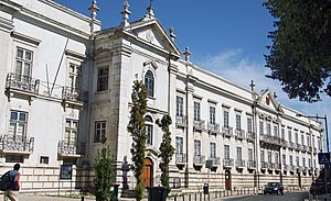
     Clockwise: Palace of the Marquises of Nisa; Madre de Deus Park; Alto de São João Cemetery; Penha de França Church; National Museum of the Azulejo. | |
 Coat of arms | |
 | |
| Coordinates: 38°43′44″N 9°07′52″W / 38.729°N 9.131°WCoordinates: 38°43′44″N 9°07′52″W / 38.729°N 9.131°W | |
| Country | |
| Region | Lisboa |
| Metropolitan area | Lisbon |
| District | Lisbon |
| Municipality | Lisbon |
| Area | |
| • Total | 2.71 km2 (1.05 sq mi) |
| Population (2011) | |
| • Total | 27,967 |
| • Density | 10,000/km2 (27,000/sq mi) |
| Time zone | UTC±00:00 (WET) |
| • Summer (DST) | UTC+01:00 (WEST) |
| Website | http://www.jf-penhafranca.pt/ |
Penha de França (Portuguese pronunciation: [ˈpɐɲɐ ðɨ ˈfɾɐ̃sɐ]) is a freguesia (civil parish) and typical quarter of Lisbon, the capital of Portugal. Located in the historic center of Lisbon, Penha de França is east of São Vicente, south of Arroios and Areeiro, and west of Beato. The population in 2011 was 27,967,[1]
History[]
The Madre de Deus Convent was founded in 1509 by Queen Leonor of Viseu. It has housed the National Museum of the Azulejo since 1965.
The freguesia of Penha de França was created on April 13, 1918.
In 1959 its area was reduced in order to create the parishes of Alto do Pina and São João.
With the 2012 Administrative Reform, the latter merged with Penha de França and the new and larger parish kept its name.[2]
Landmarks[]
- National Museum of the Azulejo
- Madre de Deus Convent
- Palace of the Marquises of Nisa
- Alto de São João Cemetery
References[]
- ^ Instituto Nacional de Estatística (INE), Census 2011 results according to the 2013 administrative division of Portugal
- ^ Diário de Notícias newspaper. "List of new parishes" (pdf) (in Portuguese). Retrieved 27 October 2013.
Categories:
- Parishes of Lisbon
- Lisbon geography stubs

