Phnom Sruoch District
Phnom Sruoch
ស្រុកភ្នំស្រួច | |
|---|---|
District (srok) | |
 Phnom Sruoch Location in Cambodia | |
| Coordinates: 11°24′N 104°24′E / 11.400°N 104.400°E | |
| Country | |
| Province | Kampong Speu |
| Communes | 12 |
| Villages | 149 |
| Population (1998)[1] | |
| • Total | 74,651 |
| Time zone | +7 |
| Geocode | 0506 |

Phnom Sruoch District (Khmer: ស្រុកភ្នំស្រួច) is a district located in Kampong Speu Province in central Cambodia.
Ecology[]
The largest surface of Kirirom National Park is part of Phnom Sruoch District, Kampong Speu, while another section is in neighboring Koh Kong Province.[2]
The Kirirom National Park is located in the eastern part of the Cardamom Mountains, about 112 km from Phnom Penh. The road from Phnom Penh to Kampong Som runs along the southern boundary of the park.
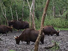
Among the animals in the park, the following deserve mention: Asian elephant, deer, gaur, banteng, leopard, spotted linsang, pileated gibbon and tiger.
Administration[]
Phnom Sruoch District is subdivided into 12 communes (khum)[3]
| Geocode | Name | |
|---|---|---|
| 050601 | ||
| 050602 | ||
| 050603 | ||
| 050604 | ||
| 050605 | ||
| 050606 | ||
| 050607 | ||
| 050608 | ||
| 050609 | ||
| 050610 | ||
| 050611 | ||
| 050613 |
References[]
- ^ General Population Census of Cambodia, 1998: Village Gazetteer. National Institute of Statistics. February 2000. pp. 106–109.
- ^ Kirirom National Park, Cambodia Archived 2009-11-17 at the Wayback Machine
- ^ National Institute of Statistics Archived 2008-07-14 at the Wayback Machine

| show |
|---|
| Authority control |
|
|---|
Coordinates: 11°24′N 104°24′E / 11.400°N 104.400°E
This Cambodian location article is a stub. You can help Wikipedia by . |
- Districts of Kampong Speu Province
- Cambodia geography stubs