Phrom Khiri District
Phrom Khiri
พรหมคีรี | |
|---|---|
 District location in Nakhon Si Thammarat Province | |
| Coordinates: 8°31′18″N 99°49′30″E / 8.52167°N 99.82500°ECoordinates: 8°31′18″N 99°49′30″E / 8.52167°N 99.82500°E | |
| Country | Thailand |
| Province | Nakhon Si Thammarat |
| Seat | Phrommalok |
| Area | |
| • Total | 321.50 km2 (124.13 sq mi) |
| Population (2012) | |
| • Total | 36,906 |
| • Density | 114.79/km2 (297.3/sq mi) |
| Time zone | UTC+7 (ICT) |
| Postal code | 80320 |
| Geocode | 8002 |

Phrom Khiri (Thai: พรหมคีรี, pronounced [pʰrōm kʰīː.rīː]) is a district (amphoe) of Nakhon Si Thammarat Province, southern Thailand.
History[]
On 26 August 1974 the minor district (king amphoe) Phrom Khiri was formed with the three tambons Phrom Lok, Ban Ko, and In Khiri split from Mueang Nakhon Si Thammarat District.[1] On 13 July 1981 it was upgraded to a full district.[2]
Geography[]
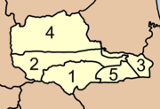
Neighboring districts are (from the north clockwise): Nopphitam, Tha Sala, Mueang Nakhon Si Thammarat, Lan Saka, and Phipun.
Administration[]
The district is divided into five sub-districts (tambons), which are further subdivided into 39 villages (mubans). There are two townships (thesaban tambons): Phrom Lok covers parts of tambons Phrom Lok and Ban Ko, and Thon Hong part of the same-named tambon. Each tambon has its non-municipal areas administered by a tambon administrative organization (TAO).
|
|
References[]
- ^ ประกาศกระทรวงมหาดไทย เรื่อง แบ่งท้องที่อำเภอเมืองนครศรีธรรมราช จังหวัดนครศรีธรรมราช ตั้งเป็นกิ่งอำเภอพรหมคีรี (PDF). Royal Gazette (in Thai). 91 (144 ก): 3285. August 27, 1974.
- ^ พระราชกฤษฎีกาตั้งอำเภอหนองใหญ่ อำเภอบ่อไร่ อำเภอพรหมคีรี อำเภอนาบอน อำเภอบางสะพานน้อย อำเภอนาดี อำเภอกงหรา อำเภอวังทรายพูน อำเภอธารโต อำเภอคำตากล้า อำเภอศรีนคร อำเภอด่านช้าง อำเภอพรเจริญ อำเภอวังสามหมอ และอำเภอลานสัก พ.ศ. ๒๕๒๔ (PDF). Royal Gazette (in Thai). 98 (115 ก Special): 7–10. July 13, 1981.
External links[]
This Nakhon Si Thammarat Province location article is a stub. You can help Wikipedia by . |
- Amphoe of Nakhon Si Thammarat Province
- Southern Thailand geography stubs