Pinamar
Pinamar | |
|---|---|
City | |
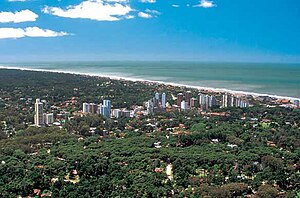 Aerial view of the city | |
 Pinamar Location in Argentina | |
| Coordinates: 37°06′S 56°51′W / 37.100°S 56.850°WCoordinates: 37°06′S 56°51′W / 37.100°S 56.850°W | |
| Country | |
| Province | |
| Partido | Pinamar |
| Founded | February 14, 1943 |
| Elevation | 17 m (56 ft) |
| Population (2020) | |
| • Total | 45.000 |
| CPA Base | B 7167 |
| Area code(s) | +54 2254 |
| Website | Official website |

Pinamar is an Argentine coastal resort city located on the coast of the Atlantic Ocean in Buenos Aires Province. It has about 45,000 inhabitants (2020).
Located less than 400 km (249 mi) south of Buenos Aires, it is one of several small seaside communities that line the coast. Since Pinamar's main attraction is the ocean, it is a fairly quiet town during the winter months. Tourism fuels the economy during the summer. Several other coastal towns are right beside Pinamar. If you move south, you will have the towns of Ostende, Valeria del Mar, and finally Cariló.
Two facts set Pinamar apart from most of the other Argentine beach cities: it is a planned city with a very strict building code, and it has been artificially turned from wild sand dunes into a forest (mostly of pine trees, which explains the "pina" in the town's name).
City planning, as defined by founding architect and maintained by elected authorities ever since, translates into a city mostly made up of residential houses with open gardens.
Pine planting was originally started in Cariló—a town nearby Villa Gesell and copied in Pinamar, although the city plan for Villa Gesell was not as carefully laid out or kept through the years.
Climate[]
| hideClimate data for Pinamar | |||||||||||||
|---|---|---|---|---|---|---|---|---|---|---|---|---|---|
| Month | Jan | Feb | Mar | Apr | May | Jun | Jul | Aug | Sep | Oct | Nov | Dec | Year |
| Average high °C (°F) | 25.8 (78.4) |
25.0 (77.0) |
23.6 (74.5) |
20.4 (68.7) |
17.0 (62.6) |
13.6 (56.5) |
13.3 (55.9) |
14.3 (57.7) |
16.1 (61.0) |
18.8 (65.8) |
21.7 (71.1) |
25.0 (77.0) |
19.6 (67.3) |
| Daily mean °C (°F) | 20.4 (68.7) |
20.1 (68.2) |
18.9 (66.0) |
15.3 (59.5) |
12.4 (54.3) |
9.1 (48.4) |
8.6 (47.5) |
9.3 (48.7) |
11.4 (52.5) |
13.8 (56.8) |
16.1 (61.0) |
19.4 (66.9) |
14.6 (58.3) |
| Average low °C (°F) | 15.8 (60.4) |
15.5 (59.9) |
14.6 (58.3) |
10.6 (51.1) |
8.5 (47.3) |
5.3 (41.5) |
4.8 (40.6) |
4.9 (40.8) |
6.9 (44.4) |
9.3 (48.7) |
11.1 (52.0) |
14.4 (57.9) |
10.1 (50.2) |
| Average precipitation mm (inches) | 136 (5.4) |
54 (2.1) |
86 (3.4) |
69 (2.7) |
90 (3.5) |
46 (1.8) |
57 (2.2) |
50 (2.0) |
54 (2.1) |
62 (2.4) |
72 (2.8) |
119 (4.7) |
895 (35.2) |
| Average precipitation days | 10 | 8 | 9 | 9 | 10 | 9 | 9 | 9 | 8 | 10 | 10 | 10 | 111 |
| Average relative humidity (%) | 70 | 72 | 74 | 76 | 79 | 79 | 81 | 76 | 77 | 73 | 69 | 70 | 75 |
| Source: Servicio Meteorológico Nacional[1] | |||||||||||||
Beach Resorts[]
There are several resorts placed in front of the sea where tourists can rent a tent or a beach umbrella. Some of them are: Bacota, Barbados, Cocodrilo, Cabo Blanco, CR, El Atlántico, El Dorado, El Más Allá, El Pájaro, El Signo, Gruta Azul, La Posta del Mar, La Rada, Las Brujas, Los Delfines, Mama Concerts, Marbella, Mirasoles, Neptunia, Paradise Beach Club, Perico, Pinamar Golf by Hemingway, Playas del Sur, Posta Norte, Posta Sur, Salvador Gaviota, San Javier, Soleil, Sport Beach, Terraza del Alba, Terrazas al Mar and UFO Point.[2][3]
Interesting facts[]
On July 2, 2019 the world's first webcam observation of the total solar eclipse below the horizon took place from this city,[4] which was at the extension of the 2019 total solar eclipse.
Sister cities[]
 Myrtle Beach, United States[5]
See also[]
References[]
- ^ "Datos Estadísticos (Período 1971–1980)" (in Spanish). Servicio Meteorológico Nacional. Retrieved October 26, 2015.
- ^ "Google". Google. Retrieved 7 January 2021.
- ^ "Balnearios y Paradores en Pinamar". Pinamar Web. Retrieved 7 February 2021.
- ^ "Solar eclipse below the horizon 2019 – the World's first webcam observation – MkrGeo". 17 February 2020.
- ^ "Interactive City Directory". Sister Cities International. Archived from the original on 20 August 2014. Retrieved 11 March 2014.
External links[]
| Wikimedia Commons has media related to Pinamar, Buenos Aires. |
- (in Spanish) Official Website
- (in Spanish) Municipal information: Municipal Affairs Federal Institute (IFAM), Municipal Affairs Secretariat, Ministry of Interior, Argentina. (in Spanish)
- (in Spanish) Revista 365: Pinamar Lifestyle Magazine
- (in Spanish) Tourist Guide to Pinamar Argentina
- (in Spanish) Information on Cariló in Pinamar
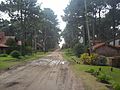
Nautilus Street
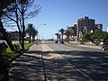
Bunge Boulevard

View of the beach from the pier


| show |
|---|
| show Provinces of Argentina |
|---|
| Authority control |
|---|
This article about a place in Buenos Aires Province, Argentina is a stub. You can help Wikipedia by . |
- Populated places in Buenos Aires Province
- Populated coastal places in Argentina
- Seaside resorts in Argentina
- Populated places established in 1943
- Buenos Aires Province geography stubs