Pocerina

Borders of the Pocerina Region in the Kingdom of Serbia
Note: This page is currently being edited. Please be patient.
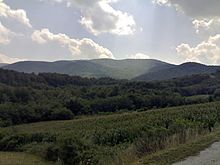
Pocerina is an area in the western part of Serbia, occupying lowland and lowland terrain on the northern side of the Cer mountain. It extends to Macva and Posavina. Potcerina was named after Mount Cer, the northernmost island mountain on the southern edge of the Pannonian Basin. Pocerina is located north of the mountain Cer. The area of Pocerina is 315 km². Two rivers flow through Potcerina: Dumača and Dobrava. Pits and sinkholes (Cerova jaruga on the border of the villages of Slatina and Bojića) appear in the limestone parts of Pocerina.
See also[]
References[]
|  | |
(*) indicates location within Kosovo | ||
Coordinates: 44°36′01″N 19°37′36″E / 44.6003°N 19.6267°E

This Serbia location article is a stub. You can help Wikipedia by . |
Categories:
- Geographical regions of Serbia
- Mačva District
- Kolubara District
- Geography of Šumadija and Western Serbia
- Serbia geography stubs