Sandžak
This article or section contains close paraphrasing of one or more non-free copyrighted sources. (May 2020) |
Sandžak
Sandžak / Санџак | |
|---|---|
Geographical region | |
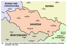
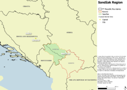 Map of Sandžak region | |
| Countries | Serbia and Montenegro |
| Largest city | Novi Pazar |
| Area | |
| • Total | 8,686 km2 (3,354 sq mi) |
| Population | |
| • Estimate (2011) | 390,737 |
| • Density | 45.33/km2 (117.4/sq mi) |
Sandžak (/ˈsændʒæk/; Serbo-Croatian: Sandžak / Санџак, pronounced [sǎndʒak]; Albanian: Sanxhaku), also known as Sanjak, is a historical[1][2][3] geo-political region in Serbia and Montenegro.[4] The name Sandžak derives from the Sanjak of Novi Pazar, a former Ottoman administrative district founded in 1865. Serbs usually refer to the region by its medieval name of Raška.
Between 1878 and 1909 the region was placed under Austro-Hungarian occupation, following which it was ceded back to the Ottoman Empire. In 1912 the region was divided between the kingdoms of Montenegro and Serbia. The most populous city in the region is Novi Pazar in Serbia.
Etymology
Sandžak is the transcription of Turkish sancak (sanjak, "province");[5] the Sanjak of Novi Pazar, known in Serbo-Croatian as Novopazarski sandžak. In Serbian, the region is known by its pre-Ottoman name, Raška.
Geography
Sandžak stretches from the southeastern border of Bosnia and Herzegovina[6] to the borders with Kosovo[7][8][9] and Albania[9] at an area of around 8,500 square kilometers. Six municipalities of Sandžak are in Serbia (Novi Pazar, Sjenica, Tutin, Prijepolje, Nova Varoš, and Priboj[10]), and five in Montenegro (Pljevlja, Bijelo Polje, Berane, Rožaje, and Plav[11]). Sometimes the Montenegrin municipality of Andrijevica is also regarded as part of Sandžak.
The most populated municipality in the region is Novi Pazar (100,410),[12] while other large municipalities are: Pljevlja (31,060),[13] and Priboj (27,133).[12] In Serbia, the municipalities of Novi Pazar and Tutin are part of the Raška District,[14] while the municipalities of Sjenica, Prijepolje, Nova Varoš, and Priboj, are part of the Zlatibor District.[14]
History
The Serbian Despotate was conquered by the Ottoman Empire in 1455. During the Ottoman era, many inhabitants converted to Islam. The conversions were caused by number of factors, mainly economic as Muslims paid lower taxes.[15] The Muslims were also privileged compared to Christians, who were unable to work in the administration or testify in court against Muslims.[16] The second factor that contributed to the Islamisation were migrations. A large demographic shift occurred after the Great Turkish War. The Turks drove the mostly Slavic-speaking Christian Orthodox population northwards, while Muslims were driven to the Ottoman territory. The land abandoned by the Serbs was settled by populations from neighbouring areas who either were or became Muslim in Sandžak. Large migrations occurred throughout the 18th and 19th century. The third factor of Islamisation was the geographical location of Sandžak, which allowed it to become a trade centre, facilitating conversions amongst merchants.[17] The tribal migrations to Sandžak had contributed a large role to its history and identity along with culture.[18][19]

The second half of the 19th century was very important in terms of shaping the current ethnic and political situation in Sandžak. Austria-Hungary supported Sandžak's separation from the Ottoman Empire, or at least its autonomy within it. The reason was to prevent Serbia and Montenegro from unifying, and allow Austria-Hungary's further expansion to the Balkans. Per these plans, Sandžak was seen as part of Bosnia and Herzegovina, while its Muslim population played a significant role giving Austrian-Hungarians a pretext of protecting the Muslim minority from the Christian Orthodox Serbs.[20]
Administratively, it was part of the Sanjak of Bosnia until 1790, when it become a separated Sanjak of Novi Pazar.[citation needed] However, in 1867, it become a part of the Bosnia Vilayet that consisted of seven sanjaks, including the Sanjak of Novi Pazar. This led to Sandžak Muslims identifying themselves with other Slavic Muslims in Bosnia.[21]
A mixture of Slavic and Albanian speakers made up the Muslim population of Sandžak at the end of the nineteenth century. Albanian speakers gradually migrated or were relocated to Kosovo and Macedonia, leaving a primarily Slavic-speaking population in the rest of the region (except in a southeastern corner of Sandžak that ended up as a part of Kosovo).[22]
In October 1912, Sandžak was captured by Serbian and Montenegrin troops in the First Balkan War, and its territory was divided between Serbia and Montenegro.[23] Many Slavic Muslims and Albanian inhabitants of Sandžak emigrated to Turkey as muhajirs. There are numerous colonies of Sandžak Bosniaks in Turkey, in and around Edirne, Istanbul, Adapazarı, Bursa, and Samsun, among other places. During World War I, Sandžak was occupied by Austria-Hungary between 1915 and 1918, as it had been previously between 1878 and 1908. Following World War I, it was included in the newly formed Kingdom of Serbs, Croats and Slovenes. It was a link between the Muslims in the West in Bosnia and Herzegovina and those in the East in Kosovo and Macedonia. Sandžak was the only region in Serbia populated by the Slavic Muslims.[20] The Sandžak Muslims suffered from the loss of their economic status since the decline of the Ottoman Empire, and during the agrarian reform carried out in the Kingdom of Yugoslavia. This led to the Muslim emigrations to the Ottoman Empire.[24]
During the Serbian army's second occupation of Rožaje, which took place in 1918-1918, seven hundred Albanian citizens were slaughtered in Rožaje (Sandžak). This was also done in order to quell uprisings in the Plav and Gusinje districts, which resulted in a large influx of Albanians migrating to Albania.[25][26]

The new communist regime in the Socialist Federal Republic of Yugoslavia found Sandžak with the Slavic Muslim minority of 43% and the Serb majority of 56%, along with smaller Albanian and Catholic minorities. During the World War II, until its abolition, Sandžak had an equal status to other federal units.[27] The Muslims, who had generally anti-Partisan attitude, wanted unification of Sandžak with Bosnia and Herzegovina, or at least to be taken as a whole either by Serbia or Montenegro. However, Sandžak was later divided between Serbia and Montenegro, the outcome the Muslims wanted the least.[28]
During the Second World War, Chetnik forces based in Montenegro conducted a series of ethnic cleansing operations against Muslims in the Bihor region of modern-day Serbia. The notables of the region then published a memorandum and declared themselves to be Albanians. The memorandum was sent to Prime Minister Ekrem Libohova whom they asked to intervene so the region could be united to the Albanian kingdom.[29]
The Anti-Fascist Council of People's Liberation of Sandžak (AVNOS) had been founded on 20 November 1943 in Pljevlja.[30] In January 1944, the Land Assembly of Montenegro and the Bay of Kotor cited Sandžak as part of a future Montenegrin federal unit. However, in March, the Communist Party opposed this, insisting that Sandžak's representatives at AVNOJ should decide on the matter.[31] In February 1945, the Presidency of the AVNOJ made a decision to oppose the Sandžak's autonomy. The AVNOJ explained that the Sandžak did not have a national basis for an autonomy and opposed crumbling of the Serbian and Montenegrin totality.[32] On 29 March 1945 in Novi Pazar, the AVNOS accepted the decision of the AVNOJ and divided itself between Serbia and Montenegro.[33] Sandžak was divided based on the 1912 demarcation line.[32]
Economically, Sandžak remained undeveloped. It had a small amount of crude and low-revenue industry. Freight was transported by trucks over poor roads. Schools for business students, which remained poor in general education, were opened for working-class youth. The Sandžak had no faculty, not even a department or any school of higher education.[24]
Sandžak saw a process of industrialisation, during which factories were opened in several cities, including Novi Pazar, Prijepolje, Priboj, Ivangrad, while the coal mines were opened in the Prijepolje area. The urbanisation caused a major social and economic shift. Many people left villages for towns. The national composition of the urban centres was changed to the disadvantage of the Muslims, as most of those who inhabited the cities were Serbs. The Muslims continued to lose their economic status, continuing the trend inherited from the time of the collapse of the Ottoman Empire and the agrarian reform in the Kingdom of Yugoslavia.[24] The emigration of the Muslims to Turkey also continued, caused by the general underdevelopment of the region, disagreement with the communist authorities and the mistrust with the Serbs and Montenegrins, but also due to the nationalisation and expropriation of property. Serbs from Sandžak also moved to the wealthier regions of the central Serbia or to Belgrade or Vojvodina, while the Muslims moved to Bosnia and Herzegovina as well.[34]
With the democratic changes in Serbia in 2000, the ethnic Bosniaks were enabled to start participating in the political life in Serbia and Montenegro, including Rasim Ljajić, an ethnic Bosniak, who was a minister in the Government of Serbia and Montenegro, and Rifat Rastoder, who is the Deputy President of the Parliament of Montenegro. Census data shows a general emigration of all nationalities from this underdeveloped region.[citation needed]
Demographics
Sandžak is a very ethnically diverse region. Most Bosniaks declared themselves ethnic Muslims in 1991 census. By the 2002-2003 census, however, most of them declared themselves Bosniaks. There is still a significant minority that identify as Muslims (by ethnicity). There are still some Albanian villages (Boroštica, Doliće and Ugao) in the Pešter region.[35] There were a larger presence of Albanians in Sandžak in the past, however due to various factors such as migration, assimilation, along with mixing, many identify as Bosniaks instead.[18][36][37]
The Slavic dialect of Gusinje and Plav (sometimes considered part of Sandžak) shows very high structural influence from Albanian. Its uniqueness in terms of language contact between Albanian and Slavic is explained by the fact that most Slavic-speakers in today's Plav and Gusinje are of Albanian origin.[38]
The total population of the municipalities of Sandžak in Serbia and Montenegro is around 385,666. A plurality of people in Sandžak identify as Bosniaks. They form 49.05% (189,186) of the region's population. Serbs form 33.5% (129,198), Montenegrins 6.90% (26,604), ethnic Muslims 6.19% (23,893), and Albanians 1.05% (4,062). About 12,724 (3.3%) people belong to smaller communities or have chosen to not declare an ethnic identity.
| Municipality | Ethnicity (2011 census) | Total | |||||||||||
|---|---|---|---|---|---|---|---|---|---|---|---|---|---|
| Bosniaks | % | Serbs | % | Montenegrins | % | Muslims | % | Albanians | % | others | % | ||
| Novi Pazar (Serbia) | 77,443 | 77.13 | 16,234 | 16.17 | 44 | 0.04 | 4,102 | 4.08 | 202 | 0.20 | 2,385 | 2.38 | 100,410 |
| Bijelo Polje (Montenegro) | 12,592 | 27.34 | 16,562 | 35.96 | 8,808 | 19.13 | 5,985 | 13.00 | 57 | 0.12 | 2,047 | 4.45 | 46,051 |
| Prijepolje (Montenegro) | 12,792 | 34.52 | 19,496 | 52.61 | 16 | 0.04 | 3,543 | 9.56 | 18 | 0.05 | 1,194 | 3.22 | 37,059 |
| Berane (Montenegro) | 6,021 | 17.72 | 14,592 | 42.95 | 8,838 | 26.02 | 1,957 | 5.76 | 70 | 0.21 | 2,492 | 7.34 | 33,970 |
| Tutin (Serbia) | 28,041 | 90.00 | 1,090 | 3.50 | 16 | 0.05 | 1,092 | 3.51 | 29 | 0.09 | 887 | 2.85 | 31,155 |
| Pljevlja (Montenegro) | 2,128 | 6.91 | 17,569 | 57.07 | 7,494 | 24.34 | 1,739 | 5.65 | 17 | 0.06 | 1,839 | 5.97 | 30,786 |
| Priboj (Serbia) | 3,811 | 14.05 | 20,582 | 75.86 | 119 | 0.44 | 1,944 | 7.16 | 3 | 0.01 | 674 | 2.48 | 27,133 |
| Sjenica (Serbia) | 19,498 | 73.88 | 5,264 | 19.94 | 15 | 0.06 | 1,234 | 4.68 | 29 | 0.11 | 352 | 1.33 | 26,392 |
| Rožaje (Montenegro) | 19,269 | 83.91 | 822 | 3.58 | 401 | 1.75 | 1,044 | 4.55 | 1,158 | 5.04 | 270 | 1.17 | 22,964 |
| Nova Varoš (Serbia) | 788 | 4.73 | 14,899 | 89.55 | 31 | 0.19 | 526 | 3.16 | 3 | 0.02 | 391 | 2.35 | 16,638 |
| Plav (Montenegro) | 6,803 | 51.90 | 2,098 | 16.00 | 822 | 6.27 | 727 | 5.55 | 2,475 | 18.88 | 183 | 1.40 | 13,108 |
| Sandžak | 189,186 | 49.05 | 129,198 | 33.50 | 26,604 | 6.90 | 23,893 | 6.19 | 4,061 | 1.05 | 12,724 | 3.30 | 385,666 |

Ethnic map of Sandžak (including Plav and Andrijevica) according to the 2002 census in Serbia and 2003 census in Montenegro. Note: map shows the ethnic majority populations within the municipalities

Ethnic map of Sandžak (excluding Plav and Andrijevica) according to the 2002 census in Serbia and 2003 census in Montenegro. Note: map shows the ethnic majority populations within the settlements


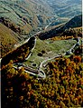
Gallery

Church of the Holy Apostles Peter and Paul, Ras near Novi Pazar, 8-9th century
Stari Ras fortress near Novi Pazar, 8th century

Đurđevi Stupovi monastery, near Novi Pazar, 12th century

White Angel, fresco from Mileševa monastery near Prijepolje, c. 1235

Sopoćani monastery, 13th century

Husein-pasha's mosque, Pljevlja

A wall built during the Ottoman period in Novi Pazar

Nova Varoš in 1930's

Kučanska Mosque, Rožaje from 1830.
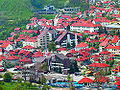
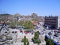
Nova Varoš Centre in 2004


See also
References
Notes
- ^ Stjepanović, Dejan (2012). "Regions and Territorial Autonomy in Southeastern Europe". In Gagnon, Alain-G.; Keating, Michael (eds.). Political autonomy and divided societies: Imagining democratic alternatives in complex settings. Palgrave Macmillan. p. 194. ISBN 9780230364257.
- ^ Roth, Clémentine (2018). Why Narratives of History Matter: Serbian and Croatian Political Discourses on European Integration. Nomos Verlag. p. 268. ISBN 9783845291000.
- ^ Duda, Jacek (2011). "Islamic community in Serbia - the Sandžak case". In Górak-Sosnowska, Katarzyna (ed.). Muslims in Poland and Eastern Europe: Widening the European Discourse on Islam. University of Warsaw: Faculty of Oriental Studies. p. 327. ISBN 9788390322957.
- ^ Karen Dawisha; Bruce Parrott (13 June 1997). Politics, Power and the Struggle for Democracy in South-East Europe. Cambridge University Press. pp. 175–. ISBN 978-0-521-59733-3.
- ^ "Dictionary.com - Sanjak entry".
- ^ "Position of the Municipality of Priboj".
- ^ "Geographic position of Municipality of Tutin".
- ^ "Geographic position of Municipality of Rožaje".
- ^ Jump up to: a b "Profile of Municipality of Plav" (PDF).
- ^ "Territorial organisation of Republic of Serbia".
- ^ "Territorial organization of Montenegro" (PDF).
- ^ Jump up to: a b "2011 Census of Population, Households and Dwellings in the Republic of Serbia" (PDF).
- ^ "2011 Census of Population, Households and Dwellings in Montenegro" (PDF).
- ^ Jump up to: a b "Government of Republic of Serbia - Administrative Okrugs (Regions)".
- ^ Górak-Sosnowska 2011, p. 328.
- ^ Todorović 2012, p. 13.
- ^ Górak-Sosnowska 2011, p. 328–329.
- ^ Jump up to: a b Memoirs of the American Folklore Society. University of Texas Press. 1954.
- ^ Elsie, Robert (2015-04-24). The Tribes of Albania: History, Society and Culture. Bloomsbury Publishing. ISBN 978-0-85772-586-8.
- ^ Jump up to: a b Górak-Sosnowska 2011, p. 329.
- ^ Todorović 2012, p. 11.
- ^ Dragostinova, Theodora; Hashamova, Yana (2016-08-20). Beyond Mosque, Church, and State: Alternative Narratives of the Nation in the Balkans. Central European University Press. ISBN 978-963-386-135-6.
- ^ "The Austrian Occupation of Novibazar, 1878–1909". Mount HolyOak. Retrieved 24 March 2012.
- ^ Jump up to: a b c Hadžišehović, Butler & Risaluddin 2003, p. 132.
- ^ Mulaj, Klejda (2008-02-22). Politics of Ethnic Cleansing: Nation-State Building and Provision of In/Security in Twentieth-Century Balkans. Lexington Books. p. 33. ISBN 978-0-7391-4667-5.
- ^ Banac, Ivo (2015-06-09). The National Question in Yugoslavia: Origins, History, Politics. Cornell University Press. pp. 298 snippet view. ISBN 978-1-5017-0194-8.
- ^ Banac 1988, p. 100.
- ^ Banac 1988, p. 100–101.
- ^ Džogović, Fehim (2020). "NEKOLIKO DOKUMENATA IZ DRŽAVNOG ARHIVA ALBANIJE U TIRANI O ČETNIČKOM GENOCIDU NAD MUSLIMANIMA BIHORA JANUARA 1943". ALMANAH - Časopis za proučavanje, prezentaciju I zaštitu kulturno-istorijske baštine Bošnjaka/Muslimana (in Bosnian) (85–86): 329–341. ISSN 0354-5342.
- ^ Jelić & Strugar 1985, p. 82, 134.
- ^ Banac 1988, p. 101.
- ^ Jump up to: a b Banac 1988, p. 102.
- ^ Jelić & Strugar 1985, p. 144.
- ^ Hadžišehović, Butler & Risaluddin 2003, p. 133.
- ^ Andrea Pieroni, Maria Elena Giusti, & Cassandra L. Quave (2011). "Cross-cultural ethnobiology in the Western Balkans: medical ethnobotany and ethnozoology among Albanians and Serbs in the Pešter Plateau, Sandžak, South-Western Serbia." Human Ecology. 39. (3): 335. "The current population of the Albanian villages is partly "bosniakicised", since in the last two generations a number of Albanian males began to intermarry with (Muslim) Bosniak women of Pešter. This is one of the reasons why locals in Ugao were declared to be "Bosniaks" in the last census of 2002, or, in Boroštica, to be simply "Muslims", and in both cases abandoning the previous ethnic label of "Albanians", which these villages used in the census conducted during "Yugoslavian" times. A number of our informants confirmed that the self-attribution "Albanian" was purposely abandoned in order to avoid problems following the Yugoslav Wars and associated violent incursions of Serbian para-military forces in the area. The oldest generation of the villagers however are still fluent in a dialect of Ghegh Albanian, which appears to have been neglected by European linguists thus far. Additionally, the presence of an Albanian minority in this area has never been brought to the attention of international stakeholders by either the former Yugoslav or the current Serbian authorities."
- ^ Banac, Ivo (2015-06-09). The National Question in Yugoslavia: Origins, History, Politics. Cornell University Press. ISBN 978-1-5017-0194-8.
- ^ Malcolm, Noel (1998). Kosovo : a short history. Internet Archive. London : Macmillan. ISBN 978-0-333-66612-8.
- ^ Matthew C., Curtis (2012). Slavic-Albanian Language Contact, Convergence, and Coexistence. The Ohio State University. p. 140.
Sources
- Bartl, Peter (1968). Die albanischen Muslime zur Zeit der nationalen Unabhängigkeitsbewegung (1878-1912). Otto Harrassowitz Verlag.
- Banac, Ivo (1988). With Stalin Against Tito: Cominformist Splits in Yugoslav Communism. Ithaca, NY: Cornell University Press. ISBN 0801421861.
- Górak-Sosnowska, Katarzyna (2011). Muslims in Poland and Eastern Europe: Widening the European Discourse on Islam. Warszaw: Faculty of Oriental Studies, University of Warszaw. ISBN 978-8390322957.
- Hadžišehović, Munevera; Butler, Thomas J.; Risaluddin, Saba (2003). A Muslim Woman in Tito's Yugoslavia. College Station, TX: Texas A&M University Press. ISBN 1585443042.
- Jelić, Ivan; Strugar, Novak (1985). War and revolution in Yugoslavia, 1941-1945. Belgrade: Socialist Thought and Practice.
- John D. Treadway (1983). The Falcon and the Eagle: Montenegro and Austria-Hungary, 1908-1914. Purdue University Press. ISBN 978-1-55753-146-9.
External links
| Wikimedia Commons has media related to Sandžak. |
- News from Sandžak sandzaknews.net
- Novi Pazar
- Info about Sandžak
- Bosniak National Council in Serbia
- Community of the Sandžak diaspora
- Centre for Bosniak Study & Bošnjačka riječ magazine

Coordinates: 43°09′47″N 19°46′30″E / 43.16306°N 19.77500°E

| show Authority control |
|---|
- Sandžak
- Historical regions in Serbia
- Historical regions in Montenegro
- Geography of Šumadija and Western Serbia
- Divided regions
- Bosnian-speaking countries and territories
- Montenegro–Serbia border
- Bosnia and Herzegovina–Serbia border
- Bosnia and Herzegovina–Montenegro border
- Kosovo–Montenegro border
- Kosovo–Serbia border
- Albanian communities in Serbia