Crmnica
Crmnica (Serbian and Montenegrin: Црмница, pronounced [tsr̩mnitsa]) is a historical region in southern Montenegro, one of the communes of the municipality of Bar. It is one of the four sub-regions of Old Montenegro.
Geography & Demographics[]
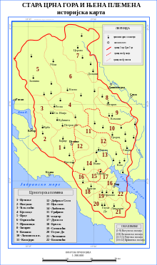
Crmnica is located in south-western Montenegro, between the historical area of the Paštrovići tribe and Shestani/Krajina to the south. Crmnica is the most fertile region of Montenegro and it is well known for a local variety of viticulture, the Vranac. In the 19th century, the region consisted of the following villages: Boljevići, , Brijege, , , , Gluhi Do, Godinje, , , , , , , Orahovo, , Podgor, , Seoca, , , , , Virpazar and . Many of them today are depopulated or completely uninhabited because of the mass emigration wave that began in the 1990s. Virpazar, the central settlement of the region, has 277 inhabitants as of 2011.[1]
The population adheres to Orthodoxy; roughly, the majority of the population declares as Montenegrins, the rest as Serbs.
History and Origin[]
Crmnica first appears in the 13th century under two different names, Crmnica and Kučevo, which is the slavicized variant of an Albanian toponym that meant "red place" (kuq). Both names refer to the fact that the region was known for its quarry of red stone. In the Middle Ages, the area shows a strong symbiosis of Slavic and Albanian populations.[2] The southern part of the area became part of the same administrative unit with Shestani when the Ottomans took over after 1479. In that period, the Slavic anthroponymy of Crmnica was frequently followed by the Albanian suffix -za. This phenomenon doesn't appear in such widespread form in any other area of Montenegro except for Mrkojevići to the south of Crmnica. It has been interpreted as the result of gradual, centuries-long adoption of Slavic culture by an Albanian-speaking population.[3]
The Ottoman census of 1582–83 registered the Vilayet of the Black Mountain (vilayet-i Kara Dağ), part of the Sanjak of Scutari, as having the following nahiyah, with number of villages: Grbavci with 13 villages, with 11, Malonšići with 7, Pješivci with 14, Cetinje with 16, with 31, Crmnica with 11, Paštrovići with 36 and Grbalj with 9 villages; a total of 148 villages.[4] One of the first detailed accounts of the villages of Crmnica was that of Venetian diplomat Mariano Bolizza who traveled in the area in 1614.[5]
References[]
- ^ "Census 2011 data - Montenegro". Monstat. Statistical Office of Montenegro. Retrieved 15 February 2020.
- ^ Milan Šufflay (2000). Izabrani politički spisi. Matica hrvatska. p. 218. Retrieved 20 March 2020.
- ^ Pulaha, Selami (1972). "Elementi shqiptar sipas onomastikës së krahinave të sanxhakut të Shkodrës [The Albanian element in view of the anthroponymy of the sanjak of Shkodra]". Studime Historike: 84–5. Retrieved 18 March 2020.
- ^ Vasić, Milan (1991), "Etnički odnosi u jugoslovensko-albanskom graničnom području prema popisnom defteru sandžaka Skadar iz 1582/83. godine", Stanovništvo slovenskog porijekla u Albaniji : zbornik radova sa međunarodnog naučnog skupa održanog u Cetinju 21, 22. i 23. juna 1990 (in Serbo-Croatian), OCLC 29549273
- ^ Bolizza, Mariano. "Report and Description of the Sanjak of Shkodra". Retrieved 28 January 2020.
Coordinates: 42°15′N 19°06′E / 42.250°N 19.100°E

| Authority control |
|
|---|
- Bar, Montenegro
- Historical regions in Montenegro
- Regions of Montenegro