Pohénégamook
This article may be expanded with text translated from the corresponding article in French. (December 2018) Click [show] for important translation instructions.
|
Pohénégamook | |
|---|---|
City | |
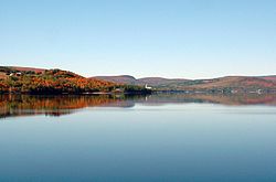 Pohenegamook Lake | |
 Location within Témiscouata RCM | |
 Pohénégamook Location in eastern Quebec | |
| Coordinates: 47°28′N 69°13′W / 47.467°N 69.217°WCoordinates: 47°28′N 69°13′W / 47.467°N 69.217°W[1] | |
| Country | |
| Province | |
| Region | Bas-Saint-Laurent |
| RCM | Témiscouata |
| Constituted | November 3, 1973 |
| Government | |
| �� Mayor | Louise Labonté |
| • Federal riding | Rimouski-Neigette— Témiscouata—Les Basques |
| • Prov. riding | Rivière-du-Loup-Témiscouata |
| Area | |
| • Total | 349.40 km2 (134.90 sq mi) |
| • Land | 340.33 km2 (131.40 sq mi) |
| Population | |
| • Total | 2,770 |
| • Density | 8.1/km2 (21/sq mi) |
| • Pop 2006-2011 | |
| • Dwellings | 1,383 |
| Time zone | UTC−5 (EST) |
| • Summer (DST) | UTC−4 (EDT) |
| Postal code(s) | G0L 1J0 |
| Area code(s) | 418 and 581 |
| Highways | |
| Website | www |

Pohénégamook, Quebec (pop. 2940) is a Canadian town on the Canada–United States border in Quebec's Témiscouata Regional County Municipality.
The town shares the border with Estcourt Station, Maine, the northernmost point in New England.
As of 2006, Pohénégamook had 2940 people, down 5.1% from the last census in 2001.
The town is named after Lake Pohenegamook and is located on the lake's southern and western shores.
Pohénégamook was amalgamated with the formerly-independent communities of Saint-Pierre d'Estcourt, Saint-Éleuthère, Village-Blier and Saint-David-de-Sully on October 23, 1973.
See also[]
- Lake Pohenegamook, a waterbody
- Boucanée River, a stream
- List of cities in Quebec
References[]
- ^ Reference number 50039 of the Commission de toponymie du Québec (in French)
- ^ a b Geographic code 13095 in the official Répertoire des municipalités (in French)
- ^ a b "(Code 2413095) Census Profile". 2011 census. Statistics Canada. 2012.
External links[]
 Media related to Pohénégamook at Wikimedia Commons
- http://www.pohenegamook.net (Pohenegamook official website)
Places adjacent to Pohénégamook | |
|---|---|
| Cities & Towns | |
|---|---|
| Municipalities | |
| Parishes |
|
| |
This Bas-Saint-Laurent location article is a stub. You can help Wikipedia by . |
Categories:
- Cities and towns in Quebec
- Incorporated places in Bas-Saint-Laurent
- Bas-Saint-Laurent geography stubs