Poinsett Colony, South Dakota
Poinsett Colony, South Dakota | |
|---|---|
 Poinsett Colony | |
| Coordinates: 44°38′32″N 96°53′57″W / 44.64222°N 96.89917°WCoordinates: 44°38′32″N 96°53′57″W / 44.64222°N 96.89917°W | |
| Country | United States |
| State | South Dakota |
| County | Hamlin |
| Area | |
| • Total | 0.25 sq mi (0.66 km2) |
| • Land | 0.25 sq mi (0.66 km2) |
| • Water | 0.0 sq mi (0.0 km2) |
| Elevation | 1,802 ft (549 m) |
| Time zone | UTC-6 (Central (CST)) |
| • Summer (DST) | UTC-5 (CDT) |
| ZIP Code | 57223 (Castlewood) |
| Area code(s) | 605 |
| FIPS code | 46-51220 |
| GNIS feature ID | 2813026[2] |


Poinsett Colony is a Hutterite colony[3] and census-designated place (CDP) in Hamlin County, South Dakota, United States. It was first listed as a CDP prior to the 2020 census.[2]
It is in the southeastern part of the county, 5 miles (8 km) north of Estelline and 12 miles (19 km) southeast of Castlewood.
References[]
- ^ "2020 U.S. Gazetteer Files – South Dakota". United States Census Bureau. Retrieved September 15, 2021.
- ^ a b "Poinsett Colony Census Designated Place". Geographic Names Information System. United States Geological Survey.
- ^ Friesen, Bert (May 2021). "Poinsett Hutterite Colony (Estelline, South Dakota, USA)". Global Anabaptist Mennonite Encyclopedia Online. Retrieved September 15, 2021.
Municipalities and communities of Hamlin County, South Dakota, United States | ||
|---|---|---|
| Cities | 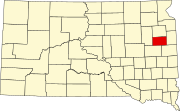 | |
| Towns | ||
| CDP |
| |
| Other communities | ||
| Footnotes | ‡This populated place also has portions in an adjacent county or counties | |
| ||
This South Dakota state location article is a stub. You can help Wikipedia by . |
Categories:
- Census-designated places in Hamlin County, South Dakota
- Census-designated places in South Dakota
- Hutterite communities
- South Dakota geography stubs