Castlewood, South Dakota
Castlewood, South Dakota | |
|---|---|
| Motto(s): "A Small Town With A Big Heart" | |
 Location in Hamlin County and the state of South Dakota | |
| Coordinates: 44°43′24″N 97°1′46″W / 44.72333°N 97.02944°WCoordinates: 44°43′24″N 97°1′46″W / 44.72333°N 97.02944°W | |
| Country | United States |
| State | South Dakota |
| County | Hamlin |
| Area | |
| • Total | 1.15 sq mi (2.98 km2) |
| • Land | 1.15 sq mi (2.98 km2) |
| • Water | 0.00 sq mi (0.00 km2) |
| Elevation | 1,686 ft (514 m) |
| Population | |
| • Total | 627 |
| • Estimate (2019)[3] | 641 |
| • Density | 557.39/sq mi (215.15/km2) |
| Time zone | UTC-6 (Central (CST)) |
| • Summer (DST) | UTC-5 (CDT) |
| ZIP code | 57223 |
| Area code(s) | 605 |
| FIPS code | 46-10500[4] |
| GNIS feature ID | 1265146[5] |
| Website | www |

Castlewood is a city in Hamlin County, South Dakota, United States. It is part of the Watertown, South Dakota Micropolitan Statistical Area. The population was 627 at the 2010 census.
History[]
Castlewood was platted in 1881 when the railroad was extended to that point.[6] The city was named Castlewood after a place mentioned in the 1857 novel The Virginians by William Makepeace Thackeray.[6] A post office has been in operation in Castlewood since 1882.[7]
Geography[]
Castlewood is located at 44°43′24″N 97°1′46″W / 44.72333°N 97.02944°W (44.723262, -97.029505),[8] along the Big Sioux River.[9]
According to the United States Census Bureau, the city has a total area of 1.15 square miles (2.98 km2), all land.[10]
Castlewood has been assigned the ZIP code 57223 and the FIPS place code 10500.
Demographics[]
| Historical population | |||
|---|---|---|---|
| Census | Pop. | %± | |
| 1900 | 430 | — | |
| 1910 | 594 | 38.1% | |
| 1920 | 582 | −2.0% | |
| 1930 | 500 | −14.1% | |
| 1940 | 493 | −1.4% | |
| 1950 | 498 | 1.0% | |
| 1960 | 500 | 0.4% | |
| 1970 | 523 | 4.6% | |
| 1980 | 557 | 6.5% | |
| 1990 | 549 | −1.4% | |
| 2000 | 666 | 21.3% | |
| 2010 | 627 | −5.9% | |
| 2019 (est.) | 641 | [3] | 2.2% |
| U.S. Decennial Census[11] | |||
2010 census[]
At the 2010 census there were 627 people in 260 households, including 158 families, in the city. The population density was 545.2 inhabitants per square mile (210.5/km2). There were 292 housing units at an average density of 253.9 per square mile (98.0/km2). The racial makeup of the city was 96.5% White, 0.5% African American, 0.5% Native American, 0.2% Asian, 1.4% from other races, and 1.0% from two or more races. Hispanic or Latino of any race were 1.8%.[2]
Of the 260 households 35.4% had children under the age of 18 living with them, 50.4% were married couples living together, 6.9% had a female householder with no husband present, 3.5% had a male householder with no wife present, and 39.2% were non-families. 33.5% of households were one person and 17.6% were one person aged 65 or older. The average household size was 2.41 and the average family size was 3.16.
The median age was 36.2 years. 28.2% of residents were under the age of 18; 7.4% were between the ages of 18 and 24; 26% were from 25 to 44; 24% were from 45 to 64; and 14.5% were 65 or older. The gender makeup of the city was 50.2% male and 49.8% female.
2000 census[]
At the 2000 census there were 666 people in 253 households, including 185 families, in the city. The population density was 585.9 people per square mile (225.6/km2). There were 265 housing units at an average density of 233.1 per square mile (89.8/km2). The racial makeup of the city was 98.95% White, 0.45% Native American, and 0.60% from two or more races. Hispanic or Latino of any race were 0.30%.[4] 38.1% were of German, 18.4% Norwegian, 9.9% Dutch, 6.8% American, 6.4% Irish and 5.6% English ancestry according to Census 2000.
Of the 253 households 40.3% had children under the age of 18 living with them, 60.5% were married couples living together, 7.9% had a female householder with no husband present, and 26.5% were non-families. 24.1% of households were one person and 14.2% were one person aged 65 or older. The average household size was 2.57 and the average family size was 3.06.
The age distribution was 28.5% under the age of 18, 8.1% from 18 to 24, 26.6% from 25 to 44, 20.6% from 45 to 64, and 16.2% 65 or older. The median age was 35 years. For every 100 females, there were 94.7 males. For every 100 females age 18 and over, there were 91.9 males.
The median income was $36,607 and the median income for a family was $41,806. Males had a median income of $29,688 versus $20,750 for females. The per capita income for the city was $17,682. About 7.7% of families and 7.1% of the population were below the poverty line, including 12.0% of those under age 18 and 6.7% of those age 65 or over.

Notable people[]
- Shane Mack – youngest person to be elected mayor in South Dakota, aged 18[12]
- Kristi Noem – Governor of South Dakota (2019–present) and U.S. Representative (2011–2019)
- Marvin Heemeyer – went on a bulldozer rampage/suicide in Colorado
See also[]
References[]
- ^ "2019 U.S. Gazetteer Files". United States Census Bureau. Retrieved July 30, 2020.
- ^ a b "U.S. Census website". United States Census Bureau. Retrieved 2012-06-21.
- ^ a b "Population and Housing Unit Estimates". United States Census Bureau. May 24, 2020. Retrieved May 27, 2020.
- ^ a b "U.S. Census website". United States Census Bureau. Retrieved 2008-01-31.
- ^ "US Board on Geographic Names". United States Geological Survey. 2007-10-25. Retrieved 2008-01-31.
- ^ a b Chicago and North Western Railway Company (1908). A History of the Origin of the Place Names Connected with the Chicago & North Western and Chicago, St. Paul, Minneapolis & Omaha Railways. p. 53.
- ^ "Hamlin County". Jim Forte Postal History. Retrieved 28 February 2015.
- ^ "US Gazetteer files: 2010, 2000, and 1990". United States Census Bureau. 2011-02-12. Retrieved 2011-04-23.
- ^ DeLorme (2001). South Dakota Atlas & Gazetteer. Yarmouth, Maine: DeLorme. ISBN 0-89933-330-3
- ^ "US Gazetteer files 2010". United States Census Bureau. Archived from the original on 2012-07-14. Retrieved 2012-06-21.
- ^ United States Census Bureau. "Census of Population and Housing". Retrieved June 13, 2016.
- ^ "High School Senior Running For Mayor Of S.D. Town". Yankton Press & Dakotan. Sioux Falls. April 6, 2002. Retrieved September 25, 2020.
External links[]
| Wikimedia Commons has media related to Castlewood, South Dakota. |
Municipalities and communities of Hamlin County, South Dakota, United States | ||
|---|---|---|
| Cities | 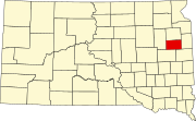 | |
| Towns | ||
| CDP |
| |
| Other communities | ||
| Footnotes | ‡This populated place also has portions in an adjacent county or counties | |
| ||
- Cities in South Dakota
- Cities in Hamlin County, South Dakota
- Watertown, South Dakota micropolitan area
- 1882 establishments in Dakota Territory
- Populated places established in 1882