Polerady (Most District)
This article includes a list of references, related reading or external links, but its sources remain unclear because it lacks inline citations. (April 2021) |
Polerady | |
|---|---|
Municipality | |
 Municipal office | |
 Flag  Coat of arms | |
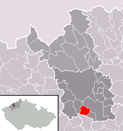 Location in Most District | |
 Polerady Location in the Czech Republic | |
| Coordinates: 50°26′30″N 13°39′35″E / 50.44167°N 13.65972°ECoordinates: 50°26′30″N 13°39′35″E / 50.44167°N 13.65972°E | |
| Country | |
| Region | Ústí nad Labem |
| District | Most |
| Area | |
| • Total | 7.07 km2 (2.73 sq mi) |
| Elevation | 218 m (715 ft) |
| Population (2007) | |
| • Total | 207 |
| • Density | 29/km2 (76/sq mi) |
| Postal code | 434 01 |
| Website | http://www.polerady.cz/ |

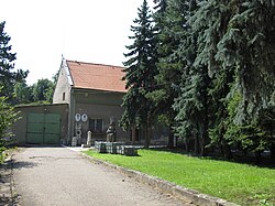
Polerady (German: Polehrad) is a village and municipality (obec) in Most District in the Ústí nad Labem Region of the Czech Republic.
The municipality covers an area of 7.07 square kilometres (2.73 sq mi), and has a population of 207 (as at 31 December 2007).
Polerady lies approximately 8 kilometres (5 mi) south of Most, 37 km (23 mi) south-west of Ústí nad Labem, and 67 km (42 mi) north-west of Prague.
References[]
External links[]
| Wikimedia Commons has media related to Polerady (Most District). |
| Authority control: National libraries |
|---|
This Ústí nad Labem Region location article is a stub. You can help Wikipedia by . |
Categories:
- Villages in Most District
- Ústí nad Labem Region geography stubs