Horní Jiřetín
Horní Jiřetín | |
|---|---|
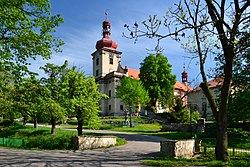 Church of the Assumption of the Virgin Mary | |
 Flag  Coat of arms | |
 Horní Jiřetín Location in the Czech Republic | |
| Coordinates: 50°34′30″N 13°32′43″E / 50.57500°N 13.54528°ECoordinates: 50°34′30″N 13°32′43″E / 50.57500°N 13.54528°E | |
| Country | |
| Region | Ústí nad Labem |
| District | Most |
| First mentioned | 1263 |
| Government | |
| • Mayor | Vladimír Buřt |
| Area | |
| • Total | 39.86 km2 (15.39 sq mi) |
| Elevation | 280 m (920 ft) |
| Population (2021-01-01)[1] | |
| • Total | 2,242 |
| • Density | 56/km2 (150/sq mi) |
| Time zone | UTC+1 (CET) |
| • Summer (DST) | UTC+2 (CEST) |
| Postal code | 435 43 |
| Website | www |

Horní Jiřetín (Czech pronunciation: [ˈɦorɲiː jɪr̝ɛciːn]; German: Obergeorgenthal) is a town in Most District in the Ústí nad Labem Region of the Czech Republic. It has about 2,200 inhabitants.
Administrative parts[]
Horní Jiřetín consists of Černice, Dolní Jiřetín, Horní Jiřetín, Jezeří and Mariánské Údolí.
Geography[]

Horní Jiřetín is located approximately 8 kilometres (5 mi) away from Most, 40 kilometres (25 mi) from Ústí nad Labem and 90 kilometres (56 mi) from Prague.
Horní Jiřetín lies in the foothills of the Ore Mountains. The highest peak of the municipal area is Homolka with 844 metres (2,769 ft) above sea level.
History[]
The first written mention of Horní Jiřetín is from 1263 under the name Jorenthal. In 1409, Jiřetín was divided into Horní ("Upper") and Dolní ("Lower") Jiřetín. During the 17th century, Horní Jiřetín was affected by the Thirty Years' War and by the great plague epidemic in 1680. From the 17th century, Horní Jiřetín, divided by the Jiřetínský stream, was mainly governed by the Lobkowicz and Waldstein families.[2]
Until the end of the World War II, the village was part of the German-speaking Sudetenland. In 1945, most of the population was expelled and replaced by Czechs.
Economy[]

In the past, the inhabitants of Jiřetín subsisted mainly on fishing in Lake Komořany, ore mining and various forms of agriculture, mainly arboriculture. Lignite has been continuously mined in Horní Jiřetín since the middle of the 19th century.[2] Today, a significant part of the municipal territory is occupied by a lignite surface mine, Lom ČSA. In 2015, the Ministry of Industry proposed breaking the mining limits imposed on the mine. This would lead to the demolition of 170 houses in Horní Jiřetín.[3] However, the proposal specifically for this mine was not accepted.[4]
In 1828, a cotton plant was built in Mariánské Údolí. It is still in operation today as the Triola company and it manufactures underwear and swimwear.[2]
Sights[]

The most important architectural monument is the Jezeří Castle incorporated into the slopes of the Ore Mountains. It was originally a Gothic castle from the 14th century, later rebuilt into the Renaissance and then into the Baroque style. Most of its English-style park was destroyed by coal mining.[2]
In Horní Jiřetín there is the valuable early-Baroque Church of the Assumption of the Virgin Mary. It was built in 1694–1700 by the plans of Jean Baptiste Mathey.[2]
Notable people[]
- Franz Joseph Glæser (1798–1861), Czech-Danish composer
- Vladimír Sommer (1921–1997), composer
- Walter Womacka (1925–2010), German artist
- Vladimír Buřt (born 1964), ecologist
Twin towns – sister cities[]
Horní Jiřetín is twinned with:[5]
 Battenberg, Germany
References[]
- ^ "Population of Municipalities – 1 January 2021". Czech Statistical Office. 2021-04-30.
- ^ Jump up to: a b c d e "O městě" (in Czech). Město Horní Jiřetín. Retrieved 2021-07-09.
- ^ "Mládek navrhne částečné prolomení limitů, podporu v koalici nemá" (in Czech). ČT24. 2015-01-29. Retrieved 2021-07-09.
- ^ "Vláda rozhodla o prolomení limitů na lomu Bílina. Těžba se zastaví 500 metrů od domů" (in Czech). Aktuálně.cz. 2015-10-19. Retrieved 2021-07-09.
- ^ "Partnerstädte" (in German). Battenberg (Eder). Retrieved 2020-06-17.
External links[]
| Wikimedia Commons has media related to Horní Jiřetín. |
| Authority control: National libraries |
|---|
- Cities and towns in the Czech Republic
- Populated places in Most District
- Towns in the Ore Mountains