Préjano
Préjano | |
|---|---|
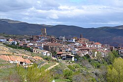 Préjano, general view | |
 Préjano Location of Préjano within La Rioja | |
| Coordinates: 42°11′10″N 2°10′48″W / 42.18611°N 2.18000°WCoordinates: 42°11′10″N 2°10′48″W / 42.18611°N 2.18000°W | |
| Country | |
| Autonomous community | |
| Comarca | Arnedo |
| Government | |
| • Mayor | Eduardo Ruiz Cubillo (PSOE) |
| Area | |
| • Total | 42.40 km2 (16.37 sq mi) |
| Elevation | 710 m (2,330 ft) |
| Population (2018)[1] | |
| • Total | 217 |
| • Density | 5.1/km2 (13/sq mi) |
| Demonym(s) | Spanish: prejanero, prejanera |
| Time zone | UTC+1 (CET) |
| • Summer (DST) | UTC+2 (CEST) |
| Postal code | 26589 |

Préjano is a village and municipality of la Rioja Baja, in the autonomous community of La Rioja, Spain. It is located on the left bank of the , tributary of the Cidacos. It is a former mining village, nowadays its inhabitants are supported by agriculture or work in industry of the nearby Arnedo, capital of the comarca.
Demography[]
As of January 2010 the population of the municipality was 237 inhabitants, 128 men and 109 women.[2]
Places of interest[]
- , 15th-century tower with a pentagonal base reinforced by inclined walls.
- , from the 16th century[3]
- Parish church of Saint Esteban
- Trujal, the most ancient olive oil press of La Rioja, still in use by the local cooperative.
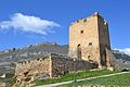
Castle of Préjano after its restoration

Trujal (olive press)


References[]
- ^ Municipal Register of Spain 2018. National Statistics Institute.
- ^ INE: Población por municipios y sexo.
- ^ San Miguel de Prejano, Patrimonio de la Rioja, 4 May 1997
Categories:
- Municipalities in La Rioja (Spain)