Precipitation shaft
| Part of a series on |
| Weather |
|---|
 |
|
|
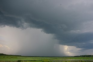
A precipitation shaft is a weather phenomenon, visible from the ground at large distances from the storm system, as a dark vertical shaft of heavy rain, hail, or snow, generally localized over a relatively small area.
This is different from a virga, which is a shaft of precipitation that evaporates before reaching the ground.
Formation[]
A precipitation shaft is mostly found underneath convective clouds, like cumulonimbus cloud or cumulus congestus cloud during a downpour storm, as these have well defined vertical drafts (updrafts and downdrafts). However, an advancing nimbostratus cloud could have a diffuse precipitation leading edge.[citation needed]
Developing rain shafts often have a fuzzy, bulbous appearance as they descend. If a source of dry air is present at higher altitude and the air into which the rain is falling is sufficiently warm, then strong, and possibly damaging microbursts are possible.[1]
See also[]
References[]
| Wikimedia Commons has media related to Praecipitatio. |
- ^ "Rain Shaft has a fuzzy, bulbous appearance". Weather World 2010. Retrieved 22 April 2016.
This climatology/meteorology–related article is a stub. You can help Wikipedia by . |
- Precipitation
- Atmospheric science stubs