Priceville, Alabama
Priceville, Alabama | |
|---|---|
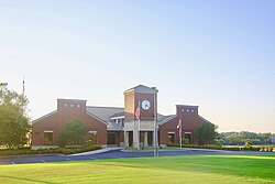 City Hall | |
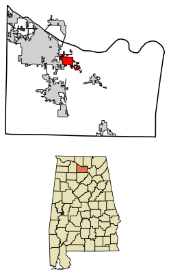 Location of Priceville in Morgan County, Alabama. | |
| Coordinates: 34°31′16″N 86°52′47″W / 34.52111°N 86.87972°W | |
| Country | United States |
| State | Alabama |
| County | Morgan |
| Area | |
| • Total | 5.86 sq mi (15.17 km2) |
| • Land | 5.83 sq mi (15.09 km2) |
| • Water | 0.03 sq mi (0.08 km2) |
| Elevation | 620 ft (189 m) |
| Population (2010) | |
| • Total | 2,658 |
| • Estimate (2019)[1] | 3,794 |
| • Density | 651.22/sq mi (251.45/km2) |
| Time zone | UTC-6 (Central (CST)) |
| • Summer (DST) | UTC-5 (CDT) |
| FIPS code | 01-62472 |
| GNIS feature ID | 0156935 |
| Website | townofpriceville |

Priceville is the third largest municipality in Morgan County, Alabama, United States and is included in the Decatur Metropolitan Area, as well as the Huntsville-Decatur Combined Statistical Area. The 2010 census counted a population of 2,658, up from 1,631.
Priceville was incorporated in 1975.[3]
History[]
Priceville was settled in the 1820s, and is named for the Price family, who played prominent roles in its early history. The community remained sparsely populated until the 1950s, when the construction of Interstate 65 brought rapid economic expansion.[4]
Geography[]
Priceville is located at 34°31′16″N 86°52′47″W / 34.52111°N 86.87972°W (34.521001, -86.879678).[5] The town lies southeast of Decatur along State Route 67. The Wheeler National Wildlife Refuge is situated between Priceville and Decatur. Interstate 65 passes through the western portion of Priceville, connecting the town with Cullman to the south and Athens to the north. The Tennessee River (Wheeler Lake) passes just north of Priceville.
According to the U.S. Census Bureau, the town has a total area of 5.2 square miles (13 km2), all land.
Demographics[]
| Historical population | |||
|---|---|---|---|
| Census | Pop. | %± | |
| 1980 | 966 | — | |
| 1990 | 1,323 | 37.0% | |
| 2000 | 1,631 | 23.3% | |
| 2010 | 2,658 | 63.0% | |
| 2019 (est.) | 3,794 | [1] | 42.7% |
| U.S. Decennial Census[6] 2013 Estimate[7] | |||
As of the census[8] of 2010, there were 2,658 people, 620 households, and 518 families residing in the town. The population density was 316.2 people per square mile (122.0/km2). There were 637 housing units at an average density of 123.5 per square mile (47.7/km2). The racial makeup of the town was 95.89% White, 2.27% Black or African American, 0.67% Native American, 0.18% Asian, 0.55% from other races, and 0.43% from two or more races. 1.23% of the population were Hispanic or Latino of any race.
There were 620 households, out of which 33.2% had children under the age of 18 living with them, 73.2% were married couples living together, 6.6% had a female householder with no husband present, and 16.3% were non-families. 13.5% of all households were made up of individuals, and 5.2% had someone living alone who was 65 years of age or older. The average household size was 2.63 and the average family size was 2.89.
In the town, the population was spread out, with 23.9% under the age of 18, 7.0% from 18 to 24, 29.7% from 25 to 44, 28.3% from 45 to 64, and 11.2% who were 65 years of age or older. The median age was 38 years. For every 100 females, there were 99.6 males. For every 100 females age 18 and over, there were 98.2 males.
The median income for a household in the town was $51,875, and the median income for a family was $55,885. Males had a median income of $37,679 versus $28,750 for females. The per capita income for the town was $22,056. About 2.2% of families and 5.6% of the population were below the poverty line, including 13.9% of those under age 18 and none of those age 65 or over.
References[]
- ^ Jump up to: a b "Population and Housing Unit Estimates". United States Census Bureau. May 24, 2020. Retrieved May 27, 2020.
- ^ "2019 U.S. Gazetteer Files". United States Census Bureau. Retrieved June 29, 2020.
- ^ http://www.decaturdaily.com/news/local/which-direction-will-priceville-voters-take-on-wet-dry-issue/article_7f08f7d7-eaf6-5c5f-b04b-ac6ef13a88b4.html
- ^ James P. Kaetz, "Priceville," Encyclopedia of Alabama, 2016.
- ^ "US Gazetteer files: 2010, 2000, and 1990". United States Census Bureau. 2011-02-12. Retrieved 2011-04-23.
- ^ "U.S. Decennial Census". Census.gov. Retrieved June 6, 2013.
- ^ "Annual Estimates of the Resident Population: April 1, 2010 to July 1, 2013". Retrieved June 3, 2014.
- ^ "U.S. Census website". United States Census Bureau. Retrieved 2008-01-31.
External links[]
| Wikimedia Commons has media related to Priceville, Alabama. |
Coordinates: 34°31′16″N 86°52′47″W / 34.521001°N 86.879678°W
| show Municipalities and communities of Morgan County, Alabama, United States |
|---|

| show Authority control |
|---|
- Towns in Morgan County, Alabama
- Towns in Alabama
- Decatur metropolitan area, Alabama
- Huntsville-Decatur-Albertville, AL Combined Statistical Area
- Alabama populated places on the Tennessee River
- 1975 establishments in Alabama