Puli Hisar District
Puli Hisar
پل حصار Pul-e Ḩişār | |
|---|---|
District | |
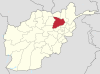
 Puli Hisar Location within Afghanistan[1] | |
| Coordinates: 35°31′56″N 69°25′41″E / 35.53222°N 69.42806°ECoordinates: 35°31′56″N 69°25′41″E / 35.53222°N 69.42806°E | |
| Country | |
| Province | Baghlan Province |
| Elevation | 3,392 m (11,129 ft) |
| Population (2012)[2] | |
| • Total | 26,800 |
Puli Hisar or Pul-e-Hesar is a district in Baghlan Province, Afghanistan.[1]
History[]
It was created in 2005 from part of Andarab District.
The district was captured by the Taliban in the 2021 offensive in which they seized control of Afghanistan. However, in August 2021, the district was one of three districts in Baghlan province that were occupied by anti-Taliban fighters (remnants of the Afghan National Army and civilian resistance fighters), marking the first wave of armed resistance to the Taliban since they seized control over the country. The other areas in which the Taliban were ousted were Dih Salah and Bano.[3]
On 23 August 2021, the Taliban once again captured all three districts that fell to the resistance forces a week ago, including Puli Hisar District.[4] However, CNN reported on 31 August 2021 that resistance fighters had once again entered Puli Hisar.[5]
Geography[]
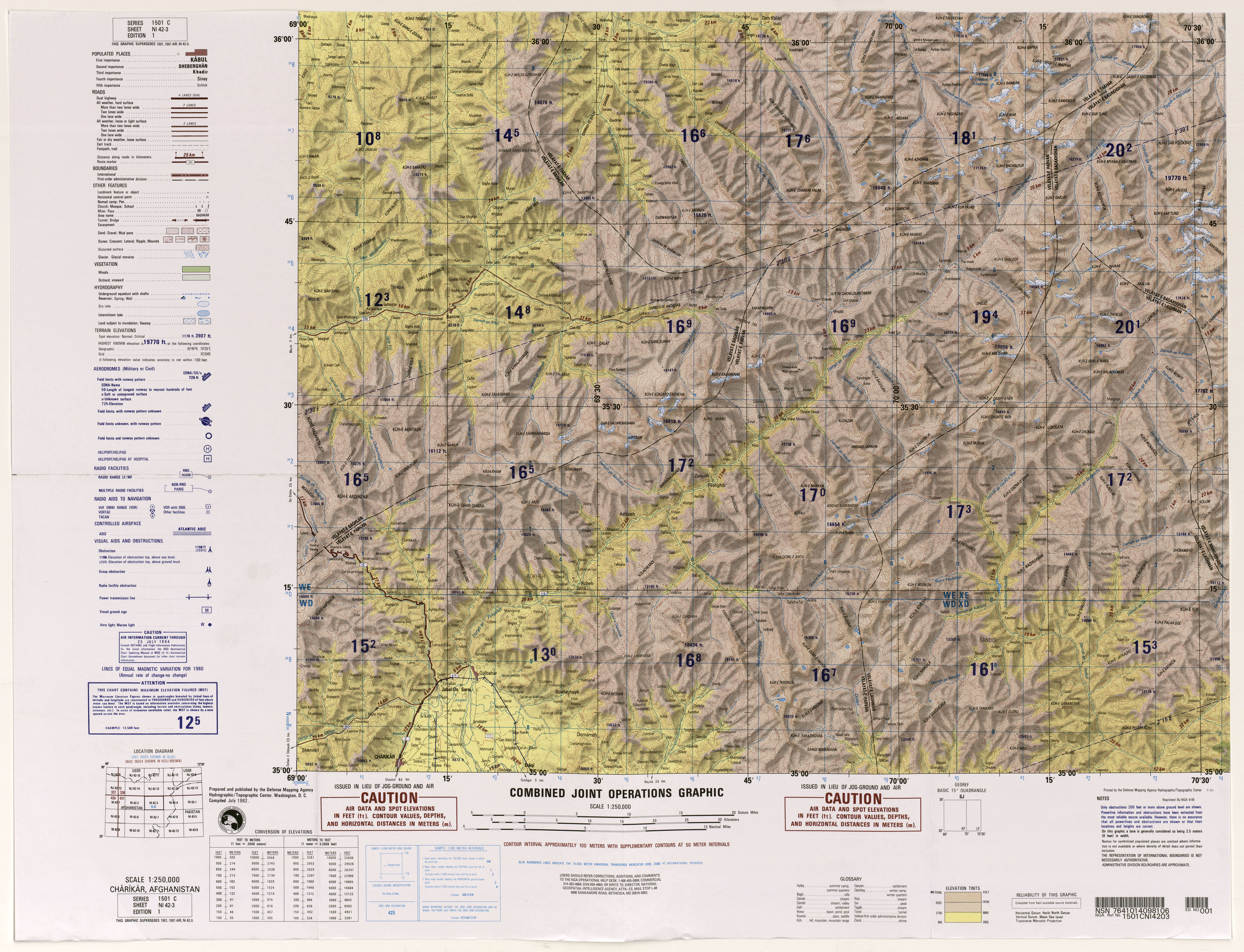
Puli Hisar District is bordered on the north by the districts of Dih Salah and Khost Wa Fereng, on the east by Panjshir Province, on the south by Panjshir and Parwan provinces, and on the west by Andarab District.[6]
There are no towns in the district, nor any large-sized villages.[7] Settlements include the small villages of Darae Su (Darah-ye Shū),[8] Ahangaran,[9] and Sar Ab.[10]
The area is mountaineous, lying within the Hindu Kush. Among its many mountains are Mount Larbach (Kōh-e Lārbāch) at 4,311 metres (14,144 ft),[11] Mount Sare Surkhi (Kōh-e Sar-e Surkhī) at about 4,306 metres (14,127 ft),[12] and on its southeastern border, Mount Shahak (Kuh-e Kokzaro Zaghicha) at 5,126 metres (16,818 ft)[13][14]
The main stream in the district is the Darwāza (Darah-ye Darwāzah), and most of the villages lie along its banks, or those of its tributaries.[15]
Climate[]
| Climate data for Puli Hisar | |||||||||||||
|---|---|---|---|---|---|---|---|---|---|---|---|---|---|
| Month | Jan | Feb | Mar | Apr | May | Jun | Jul | Aug | Sep | Oct | Nov | Dec | Year |
| Average high °F (°C) | 36 (2) |
37 (3) |
48 (9) |
59 (15) |
70 (21) |
77 (25) |
82 (28) |
81 (27) |
73 (23) |
63 (17) |
50 (10) |
41 (5) |
60 (15) |
| Average low °F (°C) | 21 (−6) |
23 (−5) |
36 (2) |
48 (9) |
57 (14) |
63 (17) |
68 (20) |
64 (18) |
59 (15) |
48 (9) |
36 (2) |
25 (−4) |
46 (8) |
| Average precipitation inches (mm) | 1.2 (31) |
3.1 (79) |
1.7 (42) |
2.4 (60) |
1.9 (47) |
0.6 (15) |
0.1 (2) |
0.1 (2) |
0.1 (3) |
0.3 (8) |
0.9 (23) |
0.6 (14) |
13 (326) |
| Source: https://www.besttimetovisit.co.in/afghanistan/pul-e-hisar-96005/january/ | |||||||||||||
Economy[]
Puli Hisar is one of Baghlan's main opium poppy cultivating districts.[16]
References[]
- ^ a b "District Names". National Democratic Institute. Archived from the original on 29 January 2016. Retrieved 17 July 2015.
- ^ "Settled Population of Baghlan province by Civil Division , Urban, Rural and Sex-2012-13" (PDF). Central Statistics Organization. Retrieved 17 July 2015.
- ^ Ezzatullah Mehrdad & Sudarsan Raghavan, Anti-Taliban fighters claim victories as first stirrings of armed resistance emerge, Washington Post (August 20, 2021).
- ^ James Mackenzie and Bernadette Baum, https://www.reuters.com/world/asia-pacific/taliban-say-they-have-retaken-three-northern-districts-seized-by-afghan-militias-2021-08-23/ Taliban near Panjshir after retaking three northern Afghan districts, Reuter (August 23, 2021).
- ^ "US completes withdrawal from Afghanistan". CNN. 31 August 2021. Retrieved 31 August 2021.
- ^ United Nations Population Fund (UNFPA) (2003). "Baghlan: A Socio-Economic and Demographic Profile" (PDF). University of California at Davis. p. vi. Archived (PDF) from the original on 16 February 2021.
- ^ United Nations Population Fund (UNFPA) 2003, p. 3
- ^ "Darah-ye Shū". GeoNames geographical database.
- ^ "Āhangarān". GeoNames geographical database.
- ^ "Sar Āb". GeoNames geographical database.
- ^ "Kōh-e Lārbāch". GeoNames geographical database.
- ^ "Sar-e Surkhī". GeoNames geographical database.
- ^ "Kuh-e Kokzaro Zaghicha, Afghanistan". Peakbagger.
- ^ "Shāhāk". GeoNames geographical database.
- ^ Chārīkār, Afghanistan, NI 42-03 (Map). 1:250,000. 1501 C. Hydrographic/Topographic Center, Defense Mapping Agency. July 1982.
- ^ Afghanistan Opium Survey 2018: Cultivation and Production (PDF). United Nations Office on Drugs and Crime (UNODC). p. 25. Archived (PDF) from the original on 21 November 2018.
Baghlan Province | ||
|---|---|---|
Capital: Puli Khumri | ||
| Districts |
|  |
| Landforms |
| |
This Baghlan Province, Afghanistan location article is a stub. You can help Wikipedia by . |
- Districts of Baghlan Province
- Baghlan Province geography stubs